


News
04 Nov. 2016 : International Workshop on Sea-Level Measurement Technologies at La Rochelle, France
04 November 2016
La Rochelle, FRANCE
– International workshop on Sea-Level Measurement Technologies (EuroGOOS Tide Gauge Task Team) - (04 November) - see flyer
The event will be held at the "Pole Communication Multimedia" amphitheater located at La Rochelle, in France.
Comitee for EuroGOOS TGTT workshop
Laurent TESTUT, LIENSs-SONEL, La Rochelle, France
Begoña PEREZ, División de Oceanografía Portuaria, Area de Medio Físico, Puertos del Estado, Spain
Vincent DONATO, SHOM, France
No registration fee, small contribution (30 €/pers.) to attend this meeting (for lunch and coffee)
10-12 March 2020 : Workshop on Sea Level Data Archaeology, Paris, France (Abstract deadline 1 Feb 2020)
Backgroung
Historical tide measurements are among the oldest direct observations which provide relevant information regarding the long-term evolution of mean sea-level. In many countries, systematic sea level observations have been carried out since the early to mid-1800s. Despite this rich historical legacy, documents with these records are hidden in archive centers. Most of these analog documents are not adequately inventoried. There can be considerable benefit in rescuing these data before they may be lost. As quoted by Ed Hawkins, working on weather data rescue : “The fastest way to collect new weather observations is by looking back in time !".
Recovery of historical sea level measurements can contribute to assessment of mean sea level trends on multi-decadal to secular timescales. In addition, they are also useful for many other scientific applications such as characterization of changes in storminess over time, estimation of river flow, study of the stability of tidal constituents, or evolution of tidal range in estuarine areas. Historical observations can be of use for coastal management via the identification and the reconstruction of past extreme events, allowing for improvement in estimation and prediction of extreme water levels.
Individual projects (single station efforts) and some concerted national campaigns have been carried out in recent years to rescue or inventory historical sea-level data. These efforts have responded to appeals by the Global Sea Level Observing System (GLOSS). At a joint meeting between the Tides, Water Level and Currents Working Group (TWCWG) of the IHO and the GLOSS Group of Experts from 11-13 April 2019, Busan (Republic of Korea), it was agreed to organize an international workshop on "Sea Level Data Archaeology". The main objective is to bring together experts concerned with sea level data rescue activities to explore the potential for a more sustained programmatic approach to cooperation at the international level.
The workshop is convened under the auspices of the Intergovernmental Oceanographic Commission of UNESCO and its Global Sea Level Observing System. The IHO TWCWG is a co-sponsor of the workshop.
Sessional topics will include :
- - Historical sea level data inventories and data at risk
- - Methodology for transfer of paper records to digital data
- - Auxiliary historical archives relative to sea level
- - Applications and knowledge products from recovered data
- - Cooperation perspectives
Structure of the workshop and submission of abstracts
The structure of the Workshop will consist of plenary sessions, panel discussions and a poster session. Abstracts for presentations (oral or poster) should be sent by no later than 1 February 2020.
Who should attend
Sea level scientists, engineers, hydrographers, experts in climate data rescue, historians, impacted users.
Conference Registration
Advanced registration is needed to attend the Workshop. There is no registration or attendance fee. Please register at workshop website (see below under “Further Information”).
Scientific committee
- - Yann Ferret, Service hydrographique et océanographique de la marine
- - Laurent Testut, University of La Rochelle
- - Thorkild Aarup, IOC
Further Information
More information about the program of the Workshop, accommodation options, and visa requirements will be made available at :
www.ioc-unesco.org
and from Thorkild Aarup, Technical Secretary of GLOSS
Read the complete PDF announcement :

10-14 July 2017: WCRP/IOC Conference on Regional Sea Level Changes and Coastal Impacts - New York, USA
ABSTRACT SUBMISSION DEADLINE EXTENSION
NEW DEADLINE: 28th February 2017
The WCRP/IOC Sea Level Conference, which will be held in New York, NY (USA) and hosted by The Earth Institute, Columbia University, on July 10-14, 2017, had a very good response from the scientific community during the abstract submission period. Many excellent contributions have been received from around the world, and from a diverse community. Due to technical issues during the last few days with the online submission system, the deadline for abstract submissions has been extended to February 28th, 2017. We encourage our colleagues from all nations to submit their abstracts and we are looking forward to seeing them at the conference.
To submit your abstract and for more details, visit the conference website: http://www.sealevel2017.org
The deadline for requests for travel support has also been extended to 28th February 2017. In case you want to apply for travel support, this can be done during the abstract submission process.
If you have any questions during this process, do not hesitate to contact us at sealevel2017@clivar.org
Eleven years after the 1st World Climate Research Program (WRCP) sea level conference held at the Intergovernmental Oceanographic Commission of UNESCO (Paris, 2006), and three years after the last Assessment Report of the Intergovernmental Panel on Climate Change (IPCC), the conference will provide a comprehensive summary of the state of worldwide climate-related large scale sea level research.
In detail the conference will:
I. Identify the key factors contributing to past, present and future regional sea level rise and variability.
II. Organize a systematic attack on the error budget of these factors.
III. Identify stakeholder needs for sea-level information for coastal planning and management purposes.
IV. Define the requirements for new and augmented research, technical development and observations consistent with the above.
The event will be held at the "Earth Institute Columbia University, Lerner Hall" at New York city in USA.
See more information at the Conference website.
Download the flyer
Committee
Scientific Chairs:
Robert Nicholls (R.J.Nicholls@soton.ac.uk)
Detlef Stammer (detlef.stammer@uni-hamburg.de)
Roderik van de Wal (R.S.W.vandeWal@uu.nl)
Local Organization:
Peter Schlosser (schlosser@ldeo.columbia.edu)
Deadlines:
December 5, 2016: Abstract submission open
February 15, 2017: Abstract submission close
March 15, 2017: Notification letter
March 15, 2017: Registration open
12-14 January 2021 : First EuroSea tide gauge network workshop
EuroGOOS has announced the date of the first of two workshops to be organised as part of the EuroSea programme. This workshop will focus on experiences, challenges and discussion around the operation of tide gauge networks.
La Rochelle University, hosting the SONEL tide gauge and GNSS data hub is involved in the organisation of the workshop and, together with colleagues from other sea level data centres, will be discussing how to improve data flow to and from data centres. There will also be sessions on :
– emerging technologies,
– the use of GNSS at tide gauges to measure land movement,
– how events such as meteo-tsunami influence extreme sea levels,
– and reports on how COVID-19 has affected the operation of sea level networks.
The meeting, because of the COVID-19 pandemic, will be fully virtual and will span three half day sessions, on 12-14 January 2021. Registration is free and available online.
More details and the official announcement by clicking on the banner below :
A second workshop focused on quality control of tide gauge data is planned for 2022.
13-15 march 2018 : Workshop on Sea-Level Measurements in Hostile Conditions
Workshop on Sea-Level Measurements in Hostile Conditions
13 - 15 March 2018, Moscow, Russian Federation
Sea level measurements often need to be carried out in what can be characterized as harsh or hostile environmental conditions. A significant part of the seas on the planet are covered with ice either on permanent or seasonal basis. Many of them, in addition, often experience storms and high waves.
The topic of sea level measurements in hostile conditions was first addressed by Global Sea Level Observing System (GLOSS) in 1988 at an IOC sponsored workshop in Bidston (UK). The Group of Experts of GLOSS has recommended to revisit the issues and to convene a new workshop which would review inter alia new measurement systems, instrument-protecting technologies, data transmission, GNSS and summarize the gained experience.
The objectives of the workshop will be :
• to exchange information and review techniques and technology for making sea level measurements in hostile regions and conditions ;
• to identify the advantages/disadvantages of available sea-level measuring technologies and new technologies required to extend existing capabilities ;
• to assess the potential to implement the sea-level network in hostile regions to meet the requirements of the Global Sea-Level Observing System.
Presentations and/or posters are invited on experiences of sea level measurements in hostile conditions of icy or/and stormy environment. Based on the contributions the workshop will aim to review and update the recommendations given in 1988.
The workshop will be held at the State Oceanographic Institute, Roshydromet, 6, Kropotkinskiy Lane, 119034, Moscow, Russian Federation.
Location
State Oceanographic Institute
6 Kropotkinsky Lane
Moscow
Russian Federation - 119034
Website : http://www.ioc-unesco.org/hostile-conditions-sea-level-workshop
Visas : Most participants will need visas to travel to Russia. Visa support for the workshop participants will be provided by local organizers. To this end the participants are requested to send the filled-out visa support forms and scans of the first page of their national passports (as described in the visa form) to Alexander Postnov (Alexander.postnov@mail.ru) not later than 1 February 2018.
Organisers & Staff :
Thorkild AARUP
Elena IASYREVA
Alexander POSTNOV
Oleg NIKITIN
View detailed participants list
Documents :
Workshop on Sea-Level Measurements in Hostile Conditions : Workshop Logistics
2–4 July 2018: Sea Level Futures Workshop, Liverpool (Abstract deadline 30 March)

Sea Level Futures Workshop, Liverpool 2–4 July 2018
Outline Plan for Sessions

This is a provisional list of sessions, some adjustment may be made nearer to the time. Every session will start with a keynote presentation followed by a series of oral and poster presentations. We welcome abstracts from all attendees.
- 1. Sea level observations: present and future
- - Role of PSMSL in sea level research
- - Present day tide gauge observing systems (GLOSS, EuroGOOS and GGOS)
- - Present and future of space observations (e.g. coastal altimetry, mass changes in the ocean, changes in the cryosphere)
- - Space geodesy for sea level
- 2. Modelling of regional sea level and its contributors
- - Challenges in modelling of sea level
- - Ocean heat content
- - Progress in modelling of the contribution from the cryosphere
- - Vertical land movement
- 3. Understanding of regional sea level rise and variability (multiple data synthesis, novel methods, synthesis of observations and models)
- - Drivers of regional sea level rise and variability
- - Novel methods and multiple data synthesis for sea level reconstructions (including paleo data)
- - Use of advance techniques for attribution of regional sea level variability
- 4. Coastal sea level rise and variability
- - Extreme sea levels in coastal area (observations and modelling)
- - Sea level variability at the coast: the role of waves
- - Advance in coastal sea level projections
- - Impact of sea level rise in coastal areas
Abstract submissions
To submit an abstract please click here submissions will close 30 March 2018
Conference Registration
– Registration covers attending the main meeting including refreshments and lunch, icebreaker reception and conference dinner.
– To register please click here
– Early bird registration £100.00 per delegate opens 1 February 2018 and closes 20 March 2018
– Standard Registration will open 21 March and close 30 April 2018 priced at £120.00 per delegate.
– Delegates notified of acceptance of posters/talks after 20 April 2018
2018 Dec 10-14: AGU Session G015 dedicated to GNSS at tide gauges
The next AGU fall meeting will take place on 2018 Dec 10-14, at Washington D.C. Part of this meeting, the session G015 is dedicated to the use of GNSS technology for coastal water level observations:
"Integration of GNSS into Water Level Observation Networks: Priorities, Technologies, and Benefits"
Tide and water level station records are some of the longest and most meticulously-kept earth observation records, but these data were historically only tied to local staffs or nearby bench marks on land. Integration of GNSS at these stations not only provides efficiencies in operational station maintenance cycles, but also adds value to these long-term water level records by connecting them to national and global reference frames and enabling the quantification of relative sea level trend components. Despite the recognized value of fusing these oceanographic and geodetic tools, only a subset of global water level stations fully leverage GNSS. This session invites the community to share new research that demonstrates the value of GNSS-linked or GNSS-enabled water level stations, exchange knowledge about best practices for instrumentation, and showcase innovative technologies or methodologies that will advance reliable, effective, and informed use of GNSS in water level observation networks.
Full session details and an abstract submission link are available here. The abstract submission deadline is on 1st August 2018 23:59 EDT.
Committee
Primary Convener:
Nicole Kinsman (NOAA National Geodetic Survey )
Co-conveners:
Adria Schneck (NOAA Center for Operational Oceanographic Products and Services)
Mike Craymer (Natural Resources Canada)
Mederic Gravelle (University of La Rochelle)
2019 Dec 9-13 : AGU Session G008 dedicated to GNSS at tide gauges
The next AGU fall meeting will take place on 2019 Dec 09-13, at San Francisco. Part of this meeting, the session G008 is dedicated to the use of GNSS technology for coastal water level observations :
"Integration of GNSS into Water Level Observation Networks : Priorities, Technologies, and Benefits"
Tide and water level stations provide some of the longest and most meticulously-kept earth observation records, but these data were once only tied to local staffs or nearby bench marks on land. Integration of GNSS at these stations not only provides efficiencies in operational station maintenance cycles, but also adds value to these long-term water level records by connecting them to national and global reference frames and enabling the quantification of relative sea level trend components. Despite the recognized value of fusing these oceanographic and geodetic tools, only a subset of global water level stations fully leverage GNSS. This session invites the community to share new research that demonstrates the value of GNSS-linked or GNSS-enabled water level stations, exchange knowledge about best practices for instrumentation, and showcase innovative technologies or methodologies such as GNSS reflectometry that will advance reliable, effective, and informed use of GNSS in water level observation networks.
Full session details and an abstract submission link are available here. The abstract submission deadline is on 31th July 2019 23:59 EDT/03:59 +1 GMT.
Committee
Primary Convener :
Nicole Kinsman (NOAA National Geodetic Survey )
Co-conveners :
Adria Schneck (NOAA Center for Operational Oceanographic Products and Services)
Mike Craymer (Natural Resources Canada)
Mederic Gravelle (University of La Rochelle)
2023 Dec 11-15 : AGU Session dedicated to GNSS for water level
The next AGU fall meeting will take place on 2023 Dec 11-15, at San Francisco. Part of this meeting, the session G018 is dedicated to the use of GNSS technology for coastal water level observations :
"Integration of GNSS into Water Level Observation Networks : Priorities, Technologies, and Benefits"
Tide and water level stations provide some of the longest and most meticulously-kept earth observation records, but these data were once only tied to local staffs or nearby bench marks on land. Integration of GNSS at these stations not only provides efficiencies in operational station maintenance cycles, but also adds value to these long-term water level records by connecting them to national and global reference frames and enabling the quantification of relative sea level trend components. Despite the recognized value of fusing these oceanographic and geodetic tools, only a subset of global water level stations fully leverage GNSS. This session invites the community to share new research that demonstrates the value of GNSS-linked or GNSS-enabled water level stations, exchange knowledge about best practices for instrumentation, and showcase innovative technologies or methodologies such as GNSS reflectometry that will advance reliable, effective, and informed use of GNSS in water level observation networks.
Full session details and an abstract submission link are available here. The abstract submission deadline is Wednesday, 2 August 2023 at 23:59 EDT.
Committee
Primary Convener :
Médéric Gravelle (LIENSs - CNRS/LRU - SONEL, France)
Co-conveners :
Begoña Pérez Gomez (Puertos del Estado, Spain)
Louis Licate (NOAA Center for Operational Oceanographic Products and Services, USA)
Alvaro Santamaria-Gomez (GET, France)
27th August to 1st September 2017: Session at the Joint IAPSO-IAMAS-IAGA Assembly 2017 in Cape Town, South Africa
– Session P05 - Advances in Monitoring, Detecting, Understanding, Hazard Assessment and Forecasting of Mean and Extreme Coastal Sea Level.
The deadline for abstracts has been extended to 12th March, 2017.
See the web site at http://www.iapso-iamas-iaga2017.com/
Rapid growth of coastal populations and nearshore development have increased the need for sea level data to understand, monitor, detect, predict and forecast current, long term and extreme variability. Data from sea level monitoring stations have a wide range of applications including research, planning, hazard assessment and operational and warning systems.
The session seeks contributions on developments in technology and operations as well as the status of sea level stations and networks. It also welcomes presentations on advances in scientific research and studies on understanding the dynamics of sea level change, as well as extreme sea level events. The session will also discuss the use of sea level data for coastal operations, hazard studies and warning systems. Advances in sea level data use for the detection and forecasting of tsunamis, storm surges, climate change and other sea level extremes are welcome, as well as contributions on techniques of sea level data analysis and data archival.
– Conveners
— Christa G. von Hillebrandt-Andrade, NOAA Caribbean Tsunami Warning Program, Lead Convener, christa.vonh@noaa.gov
— Phil Woodworth, NOC UK, plw@noc.ac.uk
— Vasily Titov, NOAA, PMEL, vasily.titov@noaa.gov
— Alexander Rabinovich , Inst. Oceanology, Russia and Inst. Ocean Sciences, Canada, a.b.rabinovich@gmail.com
29th to 31st of May 2018 : National Conference "Génie Côtier - Génie Civil" - La Rochelle
– The XVth National Conference "Génie Côtier - Génie Civil", JNGCGC 2018, organised by the association: "Centre Français du Littoral", the University of La Rochelle and their partners, will take place in La Rochelle, from the 29th to the 31st of May 2018.

THEMAS :
— Coastal hydrodynamic
— Sediment dynamic
— Instrumentation, measures and teledetection
— Water and sediment transfer in harbours and marinas
— Marine energies and ressources
— Sustainable development of coastal and estuarine zones
— Coastal risks
Instructions for a communication’s submission :
— Abstracts should be sent before 2018-02-01
— Article’s submission should be completed before 2018-03-01
For further information, please look at the specific site of this conference
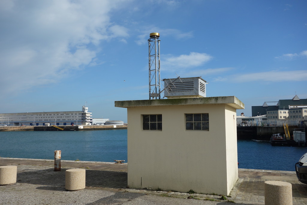
A new permanent GNSS station at Dakar GLOSS tide gauge
Dakar (Senegal) hosts one of the longest sea level records available in Africa with a multidecadal time series available at the Permanent Service for Mean Sea Level (PSMSL). The current tide gauge is operated by the University of Hawaii Sea Level centre (UHSLC) under the framework of the Global Sea Level Observing System (GLOSS) established by the Intergovernmental Oceanographic Commission (IOC) of UNESCO in 1985. Click on the left icon to display a map showing the GLOSS core network of stations, and the Dakar location within this network.
This station is locally maintained by the Lighthouses and Beacons Sub-Division of the Port Authority of Dakar. Despite the presence of permanent GNSS stations located in Dakar, these stations are distant from the tide gauge, and may not represent the vertical land motion actually experienced by the tide gauge, which is located inside one of the largest harbours in West Africa (Le Cozannet et al., 2013). See for instance the DAKA GNSS station, which in addition is decommissioned since 2007 and has discontinuities in the series, which are harmful for estimating an accurate trend. Hence, a geodetic GNSS station dedicated to monitoring the vertical land motion at the very tide gauge was highly desirable following the guidelines of the last GLOSS programme implementation plan.
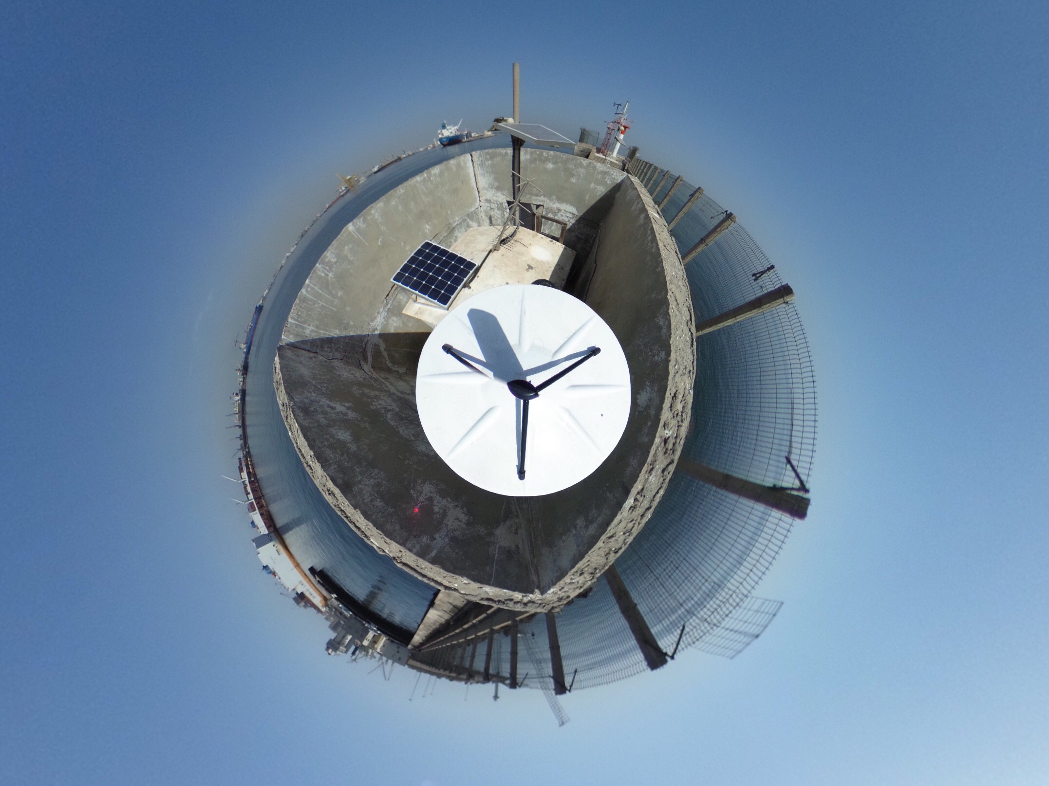
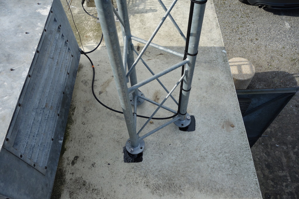
In early November 2017 a France-Senegalese team composed by SONEL partners and ANAT (Agence nationale de l’Aménagement du Territoire) installed a new permanent GNSS station at the very top of the GLOSS tide gauge. A precise levelling was performed to link the GNSS antenna to the tide gauge benchmarks. The Trimble Zephyr Geodetic antenna lies on top of a 3 meters galvanized steel mast anchored in the concrete wharf near the tide gauge hut (Click on the icons to enlarge) within a meter distance from the radar sensor at the Southern jetty of the Dakar commercial harbour.
This GNSS station is autonomous and powered by a solar panel. The measurements from the Trimble NetR9 GNSS receiver are transmitted as daily RINEX files with a sampling rate of 30s through the 4G local network. This new station is operated by the Senegalese “Direction des Travaux Géographiques et Cartographiques” (DTGC) and its data are public and freely available in accordance with the Oceanographic Data Exchange Policy of the Intergovernmental Oceanographic Commission of UNESCO at the SONEL website.
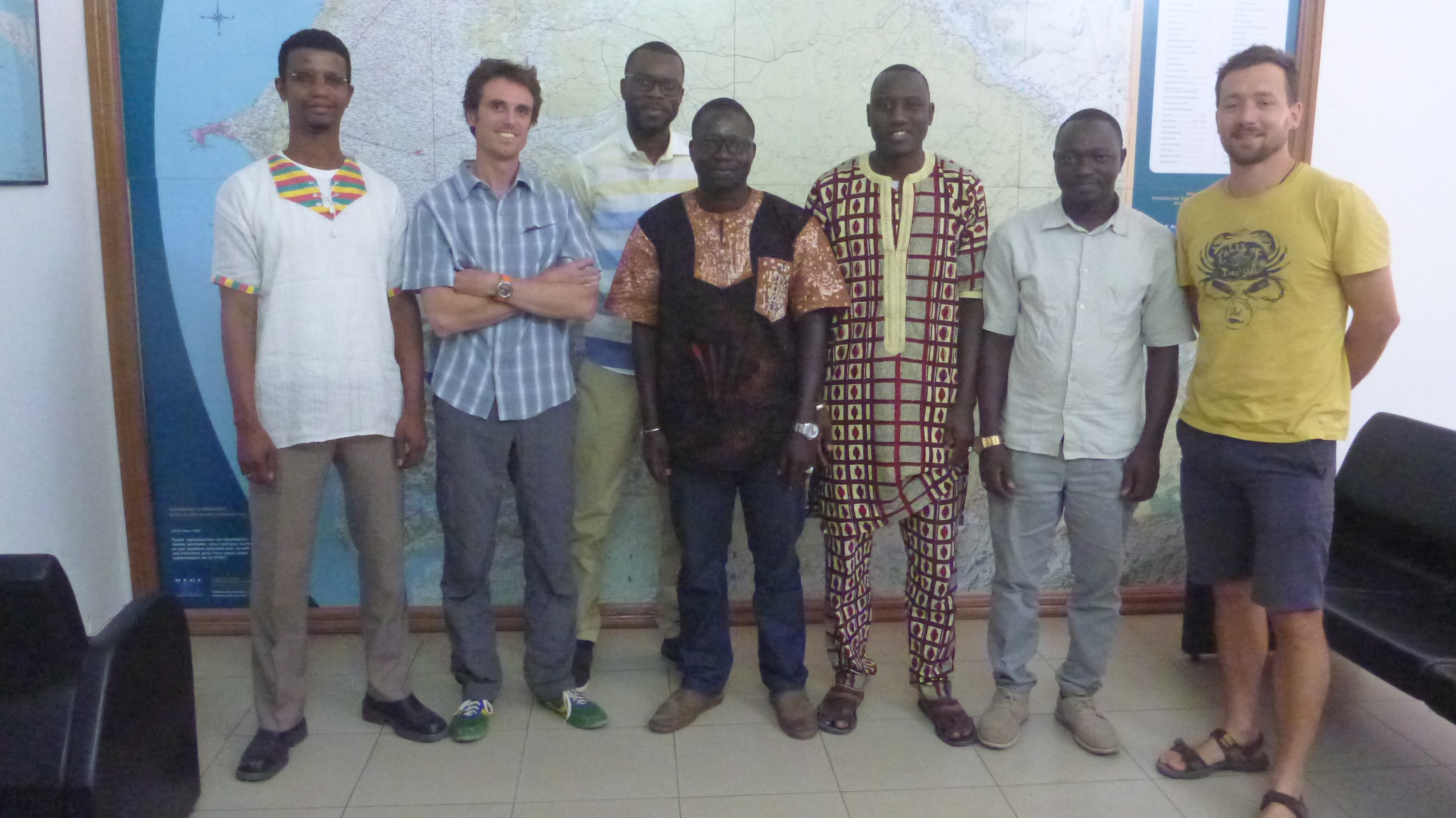
The picture on the right shows the actors of this installation (from left to right) : Oumar H. Ka (Director of DTGC/ANAT), Thomas Donal (Surveyor IGN), Abdoukarim Mbengue (IT DTGC/ANAT), Ibrahima Ndiaye (Chief Surveyor DTGC/ANAT), Dr. Issa Sakho (Assistant Professor University of Thiès), Madiabe Diouf (GIS responsible DTGC/ANAT), Etienne Poirier (Engineer LIENSs - Université de La Rochelle).
Useful References:
– Link to the SONEL webpage of this GNSS station (DATG), where further details and data can be found.
– Le Cozannet G., Raucoules D., Wöppelmann G., Garcin M., Da Sylva S., Meyssignac B., Gravelle M., Lavigne F. (2015). Vertical ground motion and historical sea-level records in Dakar (Senegal). Environnmental Research Letters, 10, doi:10.1088/1748-9326/10/8/084016.
Contact :
Copernicus Special Issue on “Developments in the Science and History of Tides”
This is to mention once again the special issue of Copernicus journals called “Developments in the Science and History of Tides”. The issue is open to any aspect of the subject including the present accuracy of coastal, regional and global tide models, tidal dissipation and its role in geophysics, internal tides and their role in mixing the ocean and in the global ocean circulation, secular changes in tides, and new techniques for measuring tides and analysing the data. Click on the thumbnail to learn more about this announcement.
In order to accommodate such a wide range of topics, the special issue spans five Copernicus journals:
- - Ocean Science – for aspects of tides in the ocean
- - Nonlinear Processes in Geophysics – for aspects of tidal dynamics including internal tides
- - Solid Earth – for aspects of solid earth and planetary tides
- - Atmospheric Chemistry and Physics – for aspects of atmospheric tides
- - History of Geo- and Space Sciences – for any aspect of the history of tidal science or scientists
The special issue is intended to mark the 100th anniversary of the founding of the Liverpool Tidal Institute (LTI). The LTI was established in 1919 and for many years was the world centre for knowledge of the tides, with Joseph Proudman taking the lead in dynamical theories, and Arthur Doodson in the analysis of tidal information from around the world, and on tidal prediction. The year 2019 is also the 100th anniversary of the IUGG, which will celebrate this anniversary during its 27th General Assembly at Montreal (Canada).The IUGG Montreal Assembly will include a Joint Symposium on Tides with IAPSO as the lead Association.
Manuscript submission:
Authors can submit their contributions by using the online registration form on the websites of any of the above journals (until the end of 2019). During the registration process, it is important that the correct special issue is selected, which is “Developments in the science and history of tides (OS/ACP/HGSS/NPG/SE inter-journal SI)”.
Papers that are accepted for publication will appear immediately on the web site of the appropriate journal. Eventually a printed version of the whole special issue will become available.
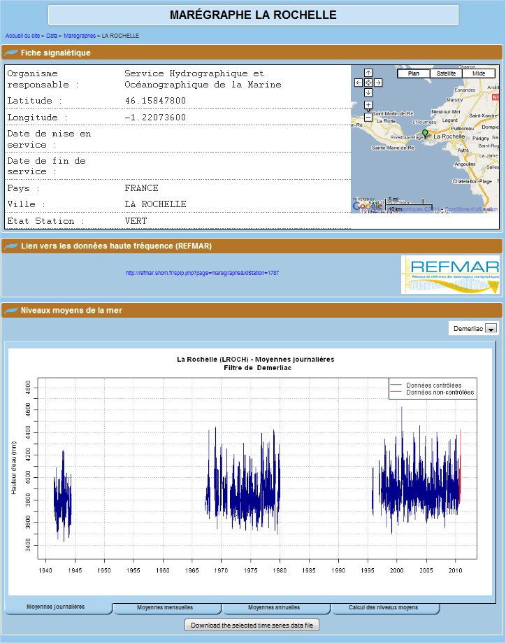
Daily, monthly and annual mean sea levels
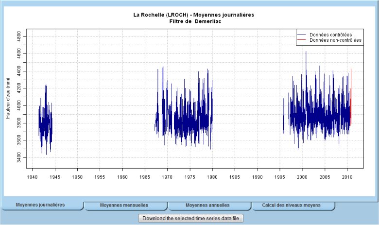
The data and graphs concerning daily, monthly and annual mean sea levels have been available on SONEL since October 2010 for the French stations (a link to the PSMSL is provided for international stations when the page specific to the station is identified and the tide gauge is co-located with GPS or DORIS). The means are calculated from the Demerliac filter and the Doodson filter (see details in the article "Calculating the mean sea levels"), with the possibility of a choice for the user.
The graphs
The graphs in the individual pages per station show the means calculated from quality controlled (QC’ed) observations (in blue) and non-QC’ed observations (in red). An example is given on the image below, which is taken from the page of the La Rochelle station.
– The non-QC’ed observations are files of raw measurements sampled every 10 minutes. A 10-min raw mesurement usually corresponds to a sea level value averaged over an integration period of two minutes (short-term oscillations such as waves are filtered out) from 1-second samples. They are not in any way verified by SHOM, and should therefore be used with the greatest of precaution, even though a high-tech modern instrument is used (See the results of experiments conducted with radar gauges published in Journal of Coastal Research). The 10-min data files are available roughly one week after the actual date on which the measurement was made.
– The QC’ed observations, which are hourly data files, have been verified by the SHOM, after being subjected to different quality controls. The values come from the 10-min. observation files which are resampled on the hour. The QC’ed data are available roughly 2-3 months after the actual date on which the measurements were made. (For details on the quality controls carried out by SHOM).
The files of average values and their format
Only the daily, monthly and annual averages calculated from QC’ed data are available. They are presented in the form of a two-column matrix : the date (in decimal years) and sea level (in millimetres). The format adopted is that of the PSMSL, as are the calculation criteria for the monthly and annual means, in particular for the issue of observation gaps.
They can be downloaded individually from the Web page of the tide gauge by clicking on the button situated under the graph of the means chosen. However, they are also available on the FTP server (ftp.sonel.org) which is very practical when a rapid acces to the data from several stations is required. This is how the names of the data files are defined :
– The first letter in lower case :
"d" for the daily means, "m" for the monthly means and "y" for the yearly means
– The acronym of the station, in capital letters, is made up of 5 letters (the internal identifier of the SONEL data base)
– The extension ".slv", for the type of quantity "sea level".
Example: the daily means file of La Rochelle is called dLROCH.slv
Structure of the file system in the FTP server
|-- legos
|   |-- rosame
|   <span class="base64" title="PGNvZGUgY2xhc3M9InNwaXBfY29kZSBzcGlwX2NvZGVfaW5saW5lIiBkaXI9Imx0ciI+LS0gc2FvX3RvbWUNCnwtLSBzaG9tDQp8ICZuYnNwOyB8LS0gSEFVVF8xMCAmbmJzcDsgJm5ic3A7ICZuYnNwOyAmbmJzcDsgJm5ic3A7ID0mZ3Q7IEZpbGVzIG9mIG9ic2VydmF0aW9ucyBhdCAxMCBtaW51dGVzDQp8ICZuYnNwOyB8ICZuYnNwOyB8LS0gUkVDRU5UICZuYnNwOyAmbmJzcDsgJm5ic3A7ICZuYnNwOyAmbmJzcDsgLSZndDsgd2l0aCB0aGUgNTAwMDAgbGF0ZXN0IG9ic2VydmF0aW9ucyBhdCAxMCBtaW4uDQp8ICZuYnNwOyB8PC9jb2RlPg=="></span>-- TOTAL            -> complete
|   <span class="base64" title="PGNvZGUgY2xhc3M9InNwaXBfY29kZSBzcGlwX2NvZGVfaW5saW5lIiBkaXI9Imx0ciI+LS0gSEFVVF9IT1IgJm5ic3A7ICZuYnNwOyAmbmJzcDsgJm5ic3A7ICZuYnNwOz0mZ3Q7IEZpbGVzIG9mIFFDJ2VkIGhvdXJseSBvYnNlcnZhdGlvbnMNCnwgJm5ic3A7ICZuYnNwOyAmbmJzcDsgfC0tIFRPVEFMICZuYnNwOyAmbmJzcDsgJm5ic3A7ICZuYnNwOyAmbmJzcDsgJm5ic3A7LSZndDsgY29tcGxldGUNCnw8L2NvZGU+"></span>-- VALID            -> with the observations of the current year
<span class="base64" title="PGNvZGUgY2xhc3M9InNwaXBfY29kZSBzcGlwX2NvZGVfaW5saW5lIiBkaXI9Imx0ciI+LS0gTVNMDQogJm5ic3A7ICZuYnNwO3wtLSBEZW1lcmxpYWMgJm5ic3A7ICZuYnNwOyAmbmJzcDsgJm5ic3A7ICZuYnNwOz0mZ3Q7IE5hbWUgb2YgdGhlIGZpbHRlciB1c2VkDQogJm5ic3A7ICZuYnNwO3wgJm5ic3A7IHwtLSBkYXRhICZuYnNwOyAmbmJzcDsgJm5ic3A7ICZuYnNwOyAmbmJzcDsgJm5ic3A7ICZuYnNwOy0mZ3Q7IEZpbGVzIG9mIG1lYW4gdmFsdWVzDQogJm5ic3A7ICZuYnNwO3w8L2NvZGU+"></span>-- graphs            -> Graphs displayed on the Web site
    <span class="base64" title="PGNvZGUgY2xhc3M9InNwaXBfY29kZSBzcGlwX2NvZGVfaW5saW5lIiBkaXI9Imx0ciI+LS0gRG9vZHNvbiAmbmJzcDsgJm5ic3A7ICZuYnNwOyAmbmJzcDsgJm5ic3A7ICZuYnNwOz0mZ3Q7IE5hbWUgb2YgdGhlIGZpbHRlciB1c2VkDQogJm5ic3A7ICZuYnNwOyAmbmJzcDsgJm5ic3A7fC0tIGRhdGEgJm5ic3A7ICZuYnNwOyAmbmJzcDsgJm5ic3A7ICZuYnNwOyAmbmJzcDsgJm5ic3A7LSZndDsgRmlsZXMgb2YgbWVhbiB2YWx1ZXM8L2NvZGU+"></span>-- graphs            -> Graphs displayed on the Web site
Reminder of the directories and their content
– legos : contains the tide gauge observations of the ROSAME network and that of Sao Tomé run by LEGOS.
– shom : contains the tide gauge observations of the RONIM network of SHOM. The sub-directory HAUT_10 contains the observations sampled at 10 min. whereas HAUT_HOR contains the QC’ed hourly observations.
– MSL (Mean Sea Level) : contains the daily, monthly and annual means, calculated from the QC’ed hourly observations.
GLOSS GE 14 and Indian Ocean Sea Level Science Workshop (19-23 October 2015)
The fourteenth session of the Group of Experts for the Global Sea Level Observing System (GLOSS) will be held at the CSIR-National Institute of Oceanography (Goa, India) during the week of 19-23 October 2015.
The week will start with a workshop dedicated to Indian Ocean Sea Level Science
(19-21 October 2015). The GLOSS GE meeting will follow on Wednesday, 21 October (afternoon) to Friday, 23 October.
Contacts :
Dr. Thorkild Aarup (IOC/UNESCO)
Dr. A.S. Unnikrishnan
Further details :
The workshop will be open to all interested persons, including those attending the GLOSS GE meeting. There is no registration fee to attend the Workshop. IOC will be able to provide travel assistance to a few participants. The workshop will have presentations covering many aspects of global and regional sea level variability including :
– Global sea level change
– Indian Ocean Sea Level changes, Mean sea level changes and Climate variability
– Sea level measurements (tsunami/ sea level network), continuous GNSS
– Impacts (Low-lying areas, mangroves, coral reefs) and Paleo sea level (Holocene),
Archeological studies
– Special session on SARAL/AltiKa satellite altimetry data analysis for sea level studies.
Students from India, countries in the Indian Ocean region and Asia are in particular encouraged to participate, as are students working with the Indo-French SARAL/AltiKa mission.
IMPORTANT :
Anyone wishing to contribute to the science workshop should send their abstract to Dr. A.S. Unnikrishnan (as.unnikrishnan@gmail.com) before 15 May 2015.
Anyone wishing to attend the workshop or the GE meeting should make their wishes known to the GLOSS Technical Secretary, Dr. Thorkild Aarup (t.aarup@unesco.org), who is responsible for the meeting agenda and attendance list.
VERY IMPORTANT :
– Registration by 1 JUNE 2015 is required due to visa process.
– See details here : final annoucement (PDF file).
– More information available at : http://ioc-unesco.org/gloss-ge-14
GLOSS GE 16 meeting, Busan, Republic of Korea (11-13 April 2019)
The sixteenth session of the Group of Experts of the Global Sea Level Observing System (GLOSS) will take place on 11-13 April 2019.
The meeting will be held back-to-back with the IHO Tides, Water Level and Currents Working Group (TWCWG), which will meet from 8 to 11 April 2019.
Contacts :
Dr. Thorkild Aarup (IOC/UNESCO)
Ms. HAN Kwang nam
Ms. KIM A ram
Location :
Korean Hydrographic and Oceanographic Agency
351, Haeyang-ro, Yeongdo-gu
Busan 49111
Republic of Korea
VERY IMPORTANT :
– Registration by 1 March 2019 is required.
Participants are expected to submit the reservation form with Annex B(Registration form) to Ms. HAN Kwang nam(hkn0112@korea.kr), Ms. KIM A am(1124kar@korea.kr) and the hotel e-mail (haeundae@shillastay.com) in order to make a reservation. The reservation for the meeting will be available until 1 March 2019 with special rate as described below.
– See details here : final annoucement (PDF file).
ASSOCIATED DOCUMENTS :
Find the action list for 2017-2019 on-line, as agreed at the GLOSS-GE-XV meeting.
MORE INFORMATION :
– More information available at : http://www.ioc-unesco.org/index.php?option=com_oe&task=viewEventRecord&eventID=2367
GPS data downloaded out of the automatic data flow (Jan. 2013 to March 2014)
The standard SONEL procedure of collecting GPS data files operates daily in an automatic mode. It treats the data that was observed and made available within the past 61 days. Out of this automatic data flow, the SONEL team is manually retrieving data files with a longer than 61 days data latency, whenever they have been informed of their availability. In order to keep updated the groups that are performing GPS data analyses, we provide here a summary of those data files that have been retrieved manually over the past year or so (Jan. 2013 to March 2014). The summary is given using the same format as previously.
See more information in the previous news about this topic.
Two files describe the manual updates : one is reminding the data files that have been downloaded manually in 2013, and the second one for the period since the beginning of 2014.

Contact :
Elizabeth Prouteau, IT Engineer
Briefly :
The summaries concern the data files that have been manually downloaded on SONEL, that is, those data files observed and made available with a latency of more than 61 days after the day of measurement.
For a single stations, the different lines correspond to different download dates. For each download date, the first and last day of downloaded data are given without taking in consideration the probable gaps during the period.
Importance of wave age and resonance in storm surges: the case Xynthia, Bay of Biscay
Researchers from the joint research unit "Littoral, Environment and Societies" (LIENSs, CNRS / La Rochelle University, team Physical Dynamics of the Littoral) in collaboration with the Portuguese National Civil Engineering Lab (LNEC, Lisbon) have investigated the storm surge associated with the storm Xynthia (February 2010) in the Bay of Biscay, combining in situ measurements with numerical modeling.
Their results show that the exceptional storm surge during Xynthia was amplified by the presence of young and steep waves in the Bay of Biscay, related to the unusual track of Xynthia. This study also shows the occurrence of a resonant phenomenon over the shelf, which explains the development of 6 hour oscillations after the surge peak.
Source:
Bertin, X., Bruneau, N., Breilh, J.F., Fortunato, A.B., Karpytchev, M., 2012.
Importance of wave age and resonance in storm surges: the case Xynthia, Bay of Biscay. Ocean Modelling, 42, pp. 16-30.
Contact:
Xavier Bertin (UMR LIENSs)
Tel. 05 46 50 76 36
Main results:
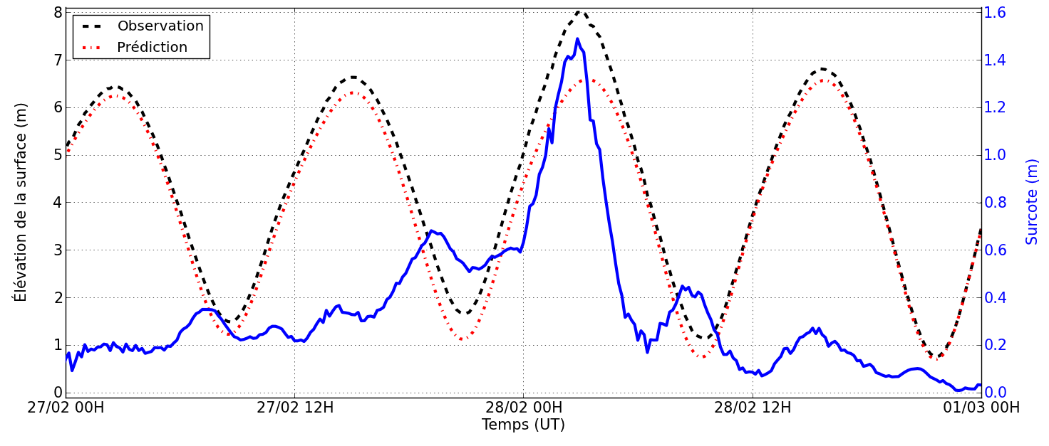
Due to the combination of a wide continental shelf and their position on the track of mid-latitude winter storms, northwestern European shorelines are exposed to storm surges that often exceed 1 m. Low-lying coasts, such as those of the Wadden Sea, Normandy (English Channel) or Pertuis Charentais (Bay of biscay) are thus vulnerable to marine flooding. The storm Xynthia, which severely hit the coasts of Vendée and Charente Maritime (central part of the Bay of Biscay) in the night between the 27th and the 28th of February 2010, reminded this vulnerability. A 970 mbar low-pressure, accompanied with southwestern winds of the order of 100 to 130 km/h (peaks at 160 km/h on Ré island), induced a storm surge with a maximum measured at 1.50 m at La Pallice tide gauge (La Rochelle, Figure 1). The surge peak matched with a high spring tide, causing the overall water level to reach 8 m above marine Chart datum, a value never attained since the deployment of the numerical tide gauge (28th of April 1997, data available at SONEL/REFMAR). Many natural barriers and dykes that protected low-lying zones breached, causing the flooding of large areas and killing 47 peoples and huge material damages estimated to 1.5 billion euros.
The study of Bertin et al. (2012) corresponds to the first step of an integrated research project aiming at investigating storm surges and marine flooding in the central part of the Bay of Biscay. A storm surge numerical modelling system was developed based on the 2DH coupling of the hydrodynamic circulation model SELFE (Zhang et Batista, 2008) and the spectral wave model WaveWatchIII (Tolman, 2009). This modeling system was implemented over the North East Atlantic Ocean and resulted in tidal predictions with errors of the order of 1 to 2 % and wave predictions with errors of the order of 15%. In the Bay of Biscay, the storm surge associated with Xynthia was reproduced with an error of the order of 0.1 m
The analysis of numerical results shows that, in the central part of the Bay of Biscay, the dominant mechanism in the storm surge generation was the SW-oriented winds, which drove an Ekman pumping. This phenomenon corresponds to water transport to the right of the wind direction, due to the Coriolis Effect. The comparison between a quadratic parameterization (wind-dependant only) and a wave-dependant parameterization to compute the wind-induced stress revealed that the storm surge was much more realistically predicted when taking waves into account (Figure 2A). This wind stress is computed based on the wind friction velocity U*, also defined as the ratio between the wave phase speed and the wave age. This friction velocity is thus very important in the presence of young and steep waves, which increase the ocean roughness (Figure 2B). Such young waves were related to the unusual track of Xynthia, which crossed the Bay of Biscay from SW to NE, thereby reducing the fetch to a few hundred kilometers only.
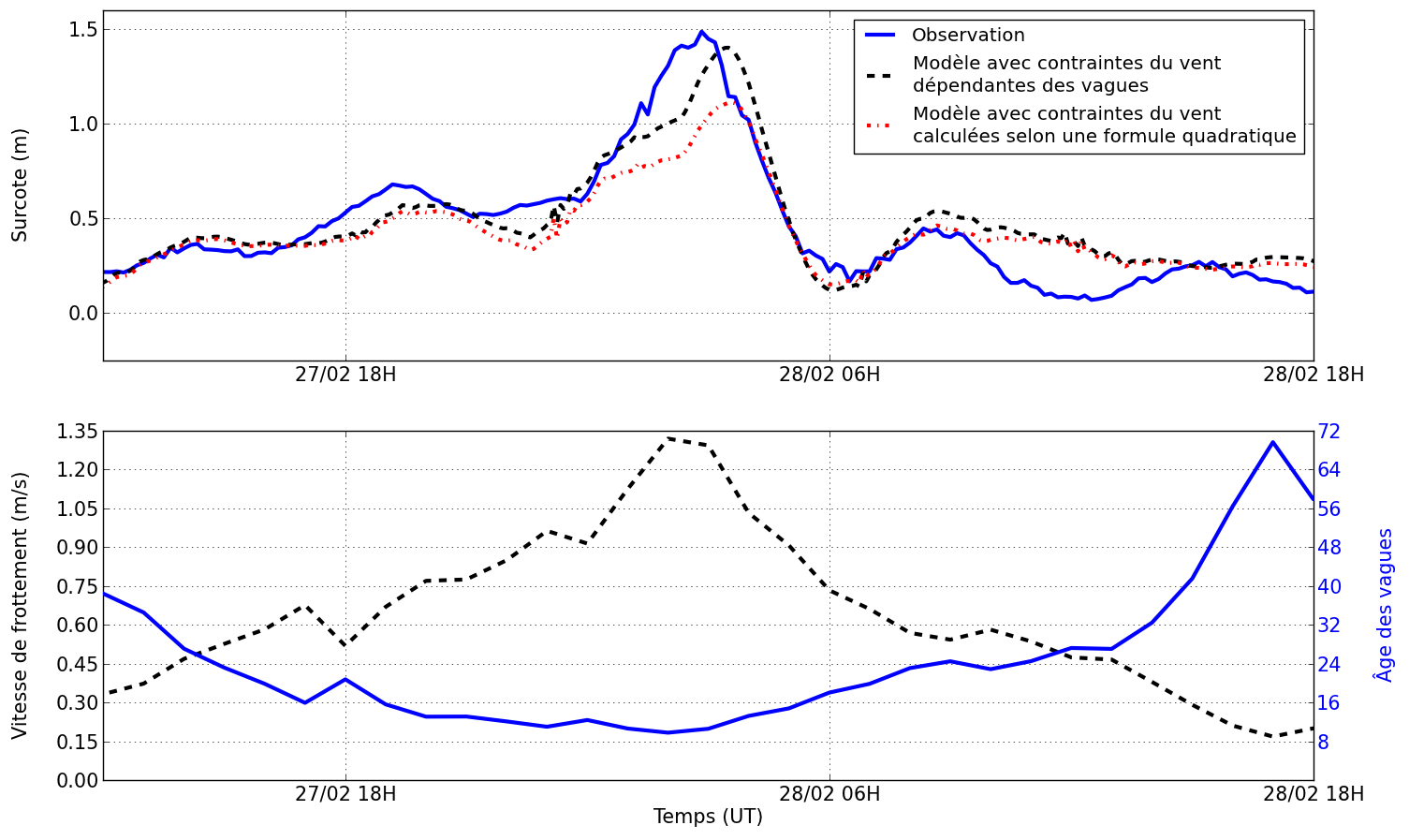
Finally, field data as well as numerical results show the occurrence of 6-hour oscillations in the storm surge signal, the height of which reaches 0.4 m in the central part of the Bay of Biscay (Figure 1, blue curve). This 6-hour period corresponds to the resonance period of the continental shelf in the central part of the Bay of Biscay. The researchers of LIENSs have interpreted this phenomenon as resulting from the fast displacement of Xynthia (15-20 m/s) in the Bay of Biscay, which induced a perturbation of the free-surface elevation with a significant amount of energy around the resonant frequency. This energy was then amplified by resonance on the shelf. Works in progress suggest that this phenomenon could be valid at other places around the world’s coastlines, such as the central part of the Gulf of Mexico, of for other long waves, such as tsunamis.
References:
– Tolman H. L., 2009. User manual and system documentation of WAVEWATCH III version 3.14. NOAA/NWS/NCEP/MMAB Technical Note 276, 194 pp.
– Zhang, Y. L. and A. M. Baptista, 2008. SELFE: A semi-implicit Eulerian-Lagrangian finite-element model for cross-scale ocean circulation. Ocean Modelling, 21(3-4), 71-96.
International workshop : Marine submersions. Past, Present, Future. 19-21 June 2014 at the University of La Rochelle
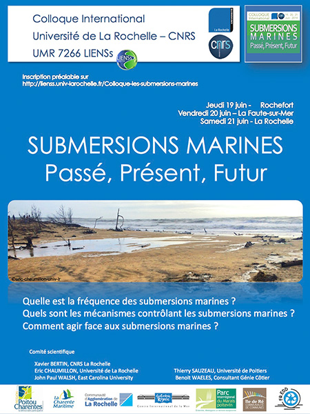
3 DAYS : 3 SITES
Thursday 19th June 2014 – Corderie Royale at Rochefort sur Mer
Friday 20th June 2014 – La Faute-sur-Mer (pavillon des dunes)
Saturday 21th June 2014 – University of La Rochelle Auditorium 250 (Jean Duvignaud) Flash hub
2 MAIN ISSUES :
- Xynthia and current marine submersions:
- Physical processes, vulnerability and risk management
- How to be prepared to future submersions in the context of climatic change ?
- Modelisation, coastal planning and prevention
- Past storms and marine sumersions
- Hindcast, Historical archives, sedimentology
- Hazard amplification factors
1 TRIP:
At La Faute sur Mer and over the rock of la Dive (Friday 20th June)
Contact and registration:
https://apps.univ-lr.fr/cgi-bin/WebObjects/Colloque.woa/1/wa/colloque?code=1141
Inventory of Sea Level Data in Need of Rescue
On behalf of GLOSS (Cover letter below), an effort has been initiated to learn of historic, non-computerized sea level data.
If your affiliation has such historic records, could you please fill in the questionnaire below (in .doc format, clicking on the image or below)?

Or if you know of contacts for such data in need of rescue, could you please provide contact information?
Send either to Mr. Patrick Caldwell from the UHSLC by May 1, 2012.
IOC Manual on Sea Level Measurement and Interpretation (Vol. V): Radar Gauges
The IOC/UNESCO just released the 5th volume of the Manual on sea level measurement and interpretation. This volume is devoted specifically to radar tide gauges. In the decade since Volume 4, they have been applied to measuring sea level at many locations. They have already replaced the previous tide gauge technologies in many countries. Their low cost (in most cases) and the fact that they are relatively easy to install and maintain mean that they have been the technology of choice whenever new sites have been instrumented or older ones refurbished.
– Part 1 of this Volume 5 discusses topics such as how radar gauges can be mounted over the water to measure sea level. It considers how gauges can be calibrated, either in the laboratory before installation or in the field during routine maintenance visits. It describes how radar performs in comparison to other technologies and discusses how the measured radar levels can be biased in the presence of waves and, consequently, what other technologies must be used in parallel.
– Part 2 of this Volume returns to some topics that have been presented in the previous Volumes 1-4 of the Manual. These are particularly important aspects of tide
gauge measurements, and so have been repeated each time, although in different ways. We suggest that new readers of the volumes would benefit from looking at Volumes 1-4 before reading the present Volume 5. Although the earlier volumes date from many years ago, and technology has evolved considerably in the meantime, much of the previous discussion is educational with regard to how the historical sea level data set has been obtained.
There are often dangers in exchanging one measuring system for another, in that different systematic methods can be introduced into a long-term time series, so an appreciation of how methods have changed is essential. It is clear that the same kind of mistakes in changing technologies could be occurring now, as radar systems replace others, so we must make attempts to understand them all as well as we can.
The online English version is available here.
A French version and a Spanish version are also available at the UNESCO documentation server.
Last data events on SONEL
On its website, SONEL highlights the last data events (see "Last data events" tab) that occured for a few weeks:
– Last downloads of data out of the automatic process - large amount of data (for the last 25 days).
– Last GNSS stations added on SONEL (for the last 2 months).
– Last sitelog updates on SONEL (for the last 4 weeks).
Contact:
Elizabeth Prouteau, Network Coordinator, IT Engineer
Briefly:
– Sitelog are updated weekly on wednesday.
– Data collect latency usually occures when a new GNSS station is added in our database or when data are made available with latency: manual collect because there is no network on the site, delay because of private interest on the data, new availablilty of an automatic process,...
See more information about SONEL’s data collect process.
New era of altimetry, new challenges - Workshop at La Rochelle, France
31 October - 04 November 2016
La Rochelle, FRANCE
3 meetings :
– SAR Altimetry Workshop (31 October ) - See program
– International Doris Service Workshop (IDS) (31 October – 01 November) - See program
– 2016 Ocean Surface Topography / Science Team (OST/ST) meeting (01–04 November) - See flyer and program
The event will be held at the "Espace Encan" at La Rochelle, in France.
See more information at the OSTST meeting webpage and the EuroGOOS TGTT workshop webpage
SONEL and the LIttoral, ENvironment and Societies department (LIENSs lab) of the La Rochelle University participate to the organisation of the "Current and past mean sea level observations" session - Tuesday, November 1st, and will animate the OST/ST splinter meeting session gathering the European tide gauges operators at 11:00 am on Thursday, November 3rd.
Comitee for OSTST meeting
Gabriele KERRMANN, Francois PARISOT, Lorna PUTZE, EUMETSAT
Laurence AMEN, Nicole BELLEFOND, Emilie BRONNER, Sophe COUTIN-FAYE, CNES
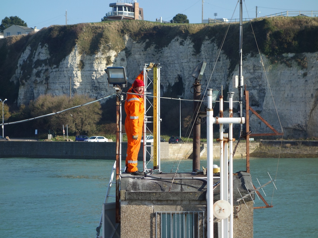
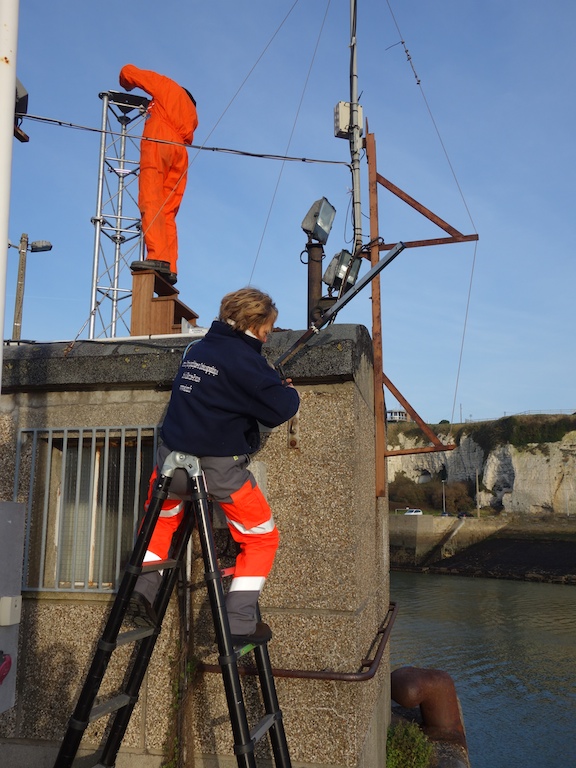
New GNSS permanent station installed at Cherbourg tide gauge site.
Since the 21st of February 2015, a GNSS permanent station is operationnal at Cherbourg tide gauge site.
Contact :
Etienne Poirier (LIENSs - ULR/CNRS)
Tel. 05 46 45 83 94
Some details:
After Dieppe in January this year, it is now Cherbourg (France) that has been chosen for the installation of a permanent GNSS station.
Operations took place at the DCNS secured site of Cherbourg from the 16 to 20 Februray 2015 during the spring tides. We were very lucky with the weather during the leveling on wednesday.
Thomas (IGN) and Etienne (University of La Rochelle) installed a 2-meter steel mast (LECLERC type) right on top of the concrete tide gauge shed. On top of the mast is now a Leica AR20 "choke ring" GNSS antenna that is connected to a Leica GR25 GNSS receiver located inside the shed.
The GNSS station is operational and the network connection is optimal. It is recording data daily at a 30 seconds sampling rate. After a few weeks of measurements, a precise reference position of this new station will be calculated.
SONEL team would like to thank all people that helped with the success of this operation, especially the DCNS that kindly accepted our presence at the Cherbourg industrial site during one week.


Photos from Thomas Donal (IGN)
More news at :
New GNSS station installed at Dieppe tide gauge site.
Since the 26th of January 2015, a GNSS permanent station is operationnal at Dieppe tide gauge site.
Contact :
Etienne Poirier (LIENSs - ULR/CNRS)
Tel. 05 46 45 83 94
Some details:
From the 19th to the 23rd of January 2015, Dieppe people have witnessed a strong activity going on around their tide gauge.
In fact, a team from SHOM came to install a Yagi antenna. This is to transmit real time atmospheric pressure data together with sea level readings to a METEOSAT satellite.
Meanwhile, SONEL people from the University of La Rochelle and IGN installed a steel mast (LECLERC type) on top of the tide gauge concrete shed to support a GNSS antenna. We chose a Leica “choke ring” type AR20 that we connected to a Leica GR25 GNSS receiver.
Despite some network telecommunications issues, the full system is now up and running.
The next step is to calculate the reference position of the station post-processing a sufficient amount of measures.
SONEL team would like to thank all people that helped with the success of this operation especially Dieppe harbour that kindly received our new GNSS station.
The next GNSS station will be installed in Cherbourg from the 16th to the 21rd of February.

Photos from Thomas Donal (IGN)
More news at :
New GNSS stations 2016
At the end of 2016, SONEL database number of GNSS@TG stations exceeded 900 permanent stations (914).
In 2016, six new stations were installed and integrated in the SONEL system:
– BGBC (Bourg Blanc), installed 2016-06-07,
– FRRL (FERROL - Puerto Exterior), installed in 2016-04-08 - New on this site near the tide gauge,
– WQSL (GPS Wake TG), installed in 2016-04-04 - New on this site less than 100m from the tide gauge,
– OWMG (Chatham Island - Owenga), installed in 2016-03-01,
– STMT (Saint Martin), installed in 2016-02-18, less than 100m from the tide gauge,
– APS1 (SANTANA - DOCAS), installed 2016-01-26, less than 1km from the tide gauge.
In 2016, ten GNSS stations installed in 2015 were also added to SONEL:
– BCL1 (Barcelona), installed in 2015-12-02,
– CANN (Cannes), installed in 2015-11-30, decommissionned since 2016-12-12, should be replaced soon,
– XIXO (Gijon), installed in 2015-11-12 - New on this site near the tide gauge,
– MRTG (Maré), installed in 2015-11-05 - New on this site less than 100m from the tide gauge; it was tied (levelling) to the tide gauge,
– SAS2 (Sassnitz), installed in 2015-10-22 - less than 100 m from tide gauge,
– MQSI (MIDWAY TG), installed in 2015-10-15 - New on this site less than 100m from the tide gauge,
– ASCG (ASCENSION), installed 2015-07-24, was tied (levelling) to the tide gauge,
– TGDR (BarahoTG_DOM2015), installed in 2015-07-08,
– UCA1 (Puerto Real - Cadiz), installed in 2015-06-01,
– SEY2 (Seychelles), installed in 2015-02-19, it was tied (levelling) to the tide gauge.
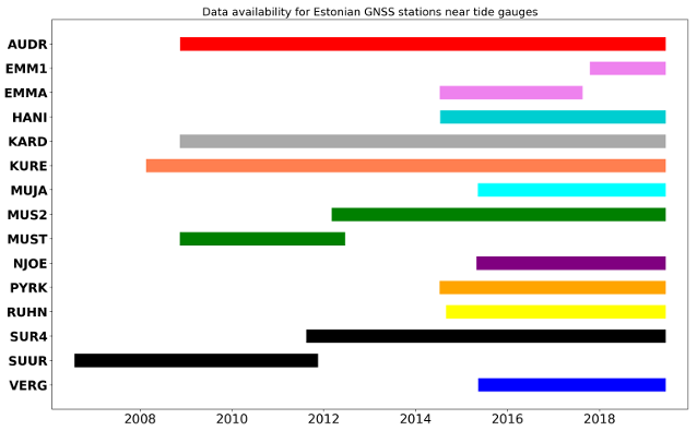
New GNSS@TG contribution from Estonia (12 stations from MAA-MET)
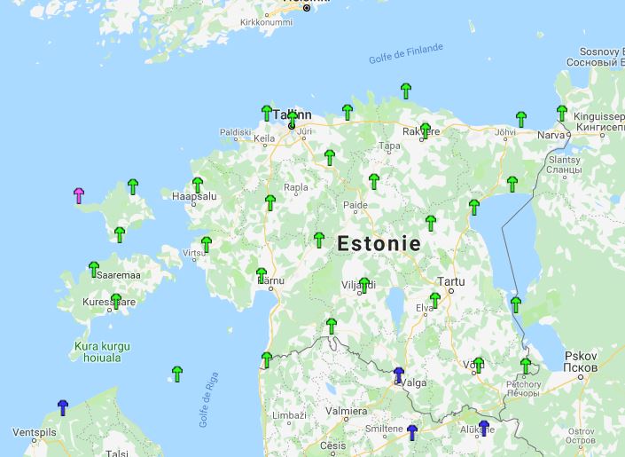
The Estonian Land Board (MAA-AMET Service) operates the ESTPOS network, which currently consists of 29 permanent GNSS stations homogeneously distributed across the country (click on the right map to enlarge, and see their location, in green). Four of these stations contribute to the EUREF permanent GNSS network, namely:
- - Kuressaare (KURE)
- - Suurupi (SUR4),
- - Toila (TOIL),
- - and Toravere (TOR2). Click on the 4 character GNSS identifier to access the EUREF webpage of a particular station, and see its details (pictures, local map, etc.).
Out of the 29 GNSS stations, 12 are co-located at (or nearby) tide gauges. By making their observations available to SONEL, the Estonian Land Board contributes to the scientific objectives of the global sea level observing programme (GLOSS) and to the IGS Working Group (TIGA) on GNSS tide gauge benchmark monitoring. These data contribute to assess the vertical stability of the land upon which the tide gauges are grounded. As SONEL users know, this information on vertical land motion is key to understanding sea level change and variability as observed by tide gauges, in particular to separate contributions from climate change (e.g., land ice melting, thermal expansion) and from solid Earth (e.g., subsidence due to groundwater extraction, sediment compaction, or post-glacial rebound).
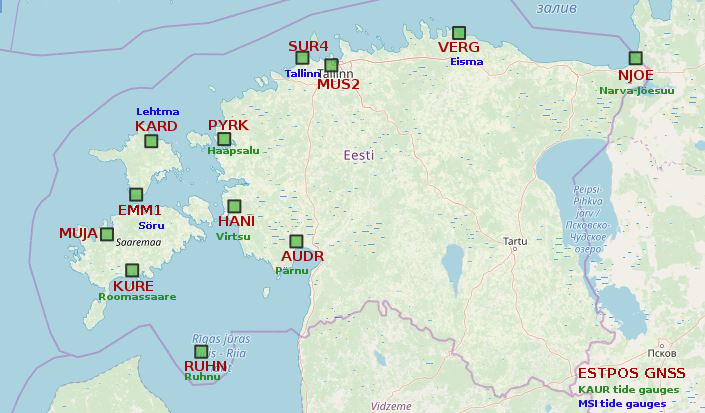

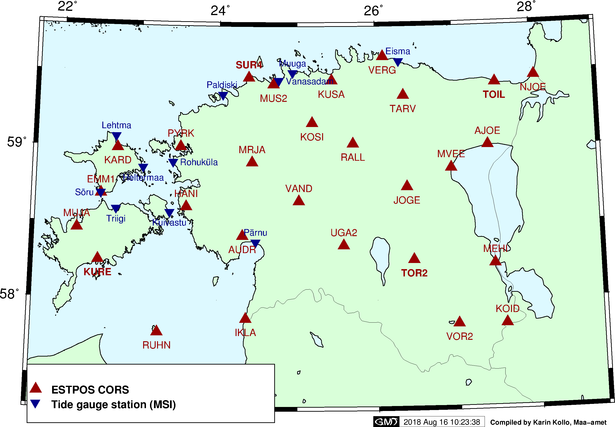
The 12 permanent GNSS stations are co-located with tide gauges from two networks / agencies, namely from the Estonian Environmental Agency (KAUR) and from the Maritime Institute (MSI) at Tallinn University of Technology. Click on the right thumbnail maps to enlarge, and get an overview of the location of the tide gauges within each network.
End of 2018, SONEL has contacted the Estonian Land Board (MAA-AMET Service), regarding the data availability of the 12 permanent GNSS stations installed near a tide gauge. And since January 2019, the daily observation in RINEX format are available on SONEL. The timeline below shows the record length for each station, and data availability for each of the 12 GNSS stations.
| GPS NAME | ACRONYM | LATITUDE | LONGITUDE | TIDE GAUGE | DISTANCE TIDE GAUGE-GNSS | INSTALLATION DATE | LENGTH |
|---|---|---|---|---|---|---|---|
| AUDRU | AUDR | 58.38472222 | 24.48083333 | PARNU | 10616 m | 2007-11-13 | 10 years |
| EMMASTE | EMM1 | 58.69138889 | 22.52194444 | SORU | 1831 m | 2017-12-06 | 1 years |
| EMMASTE | EMMA | 58.69138889 | 22.52194444 | SORU | 1830 m | 2014-09-01 | 3 years |
| HANILA | HANI | 58.57611111 | 23.50888889 | VIRTSU | 8918 m | 2014-09-05 | 4 years |
| KARDLA | KARD | 59.06944444 | 22.69861111 | LEHTMA | 8442 m | 2008-08-06 | 10 years |
| KURESSAARE | KURE | 58.21385833 | 22.50571389 | ROOMASSAARE | 4657 m | 2007-11-15 | 11 years |
| MUSTJALA | MUJA | 58.53361111 | 22.23388889 | SAAREMAA HARBOUR | 7843 m | 2015-09-04 | 4 years |
| MUSTAMAE2 | MUS2 | 59.44939200 | 24.77554800 | TALLINN | 5397 m | 2012-04-25 | 7 years |
| TALLINN | MUST | 59.44939200 | 24.77554800 | TALLINN | 5464 m | 2009-01-01 | 3 years |
| NARVA-JOESUU | NJOE | 59.46305556 | 28.04583333 | NARVA-JOESUU | 366 m | 2015-06-18 | 4 years |
| PURKSI | PYRK | 58.94444444 | 23.55500000 | HAAPSALU | 7181 m | 2014-08-25 | 4.5 years |
| RUHNU | RUHN | 57.78333333 | 23.25888889 | RUHNU | 598 m | 2014-10-18 | 4.5 years |
| SUURUPI | SUR4 | 59.44939200 | 24.77554800 | TALLINN | 22418 m | 2011-09-21 | 7.5 years |
| SUURUPI | SUUR | 59.44939200 | 24.77554800 | TALLINN | 22417 m | 1996-11-29 | 5 years |
| VERGI | VERG | 59.56916667 | 26.30416667 | EISMA | 12013 m | 2015-07-03 | 4 years |
New GPS data, out of the standard stream of collection (period 2012 to Jan. 2013)
Regular campaigns are undertaken by the SONEL team to incorporate new stations and observations in the GPS database . If those stations are newly installed, their data enter the standard stream of automatic collection that intercompares the SONEL data holdings with those of the remote data center, and only the missing files within the last 60 days are collected. Consequently, newly reported stations operating for longer than 60 days require a manual procedure.
This news is to inform about the results of those manual campaigns of data collection which take place at regular intervals, whenever a new agency contributes its GPS data to the geodetic monitoring of tide gauges (following the free and public data policy of the WMO and IOC programs such as GLOSS).
Contact :
Elizabeth Prouteau, IT Engineer
Briefly :
SONEL automatically collects daily the data of several hundreds of GPS@TG stations, and distributes them via FTP and Web servers. Regularly, a few new stations are added, and their data collected at once for long time periods over 60 days. In addition, the IGS or EUREF often alerts on newly available data, either because the remote link with the station was interrupted for a long period of time or because the data files were corrupted but later on the correct files were ultimately gathered, thereby offering the opportunity to complete the SONEL data holdings.
The file here provided (click on the right picture) provides a summary on the manual collection campaigns of GPS data that have taken place between January 2012 and January 2013 (included). Those concern observations that may have been recorded between 1986 and 2012.
For one station, the different lines correspond to different download dates. For each download date, the first and last day of downloaded data are given, without specifying the data gaps during that period.
A news will keep you informed on the manual collection campaigns, likely monthly, whenever it has resulted in substantial new data acquisition.
New tools on SONEL and design of the homepage
Since the last GLOSS group of experts meeting, the SONEL team at ULR has been working on making the GPS products at tide gauges more readily accessible. A first step towards this goal has been realized by 1 redesigning the homepage, and 2 by providing new tools to display the GPS position time series with options such as including or not the velocity, the annual cycle or the (detected) offsets.
Contacts :
Mikaël Guichard, IT Engineer
Médéric Gravelle, Research Engineer
Briefly :
The first important change concerns the homepage. A new panel called "Sea and land levels at the coast" has been created and linked to the GPS solutions page. The organization of the data in the GPS solutions page is currently under review. An important perspective is to provide combined products from the GPS and the tide gauge data analyses such as absolute (geocentric) rates of sea level change. This perspective is worked out with our colleagues from the PSMSL where relative (with respect to the coast) rates of sea level change can already be retrieved from the sole analyses of the tide gauge data.
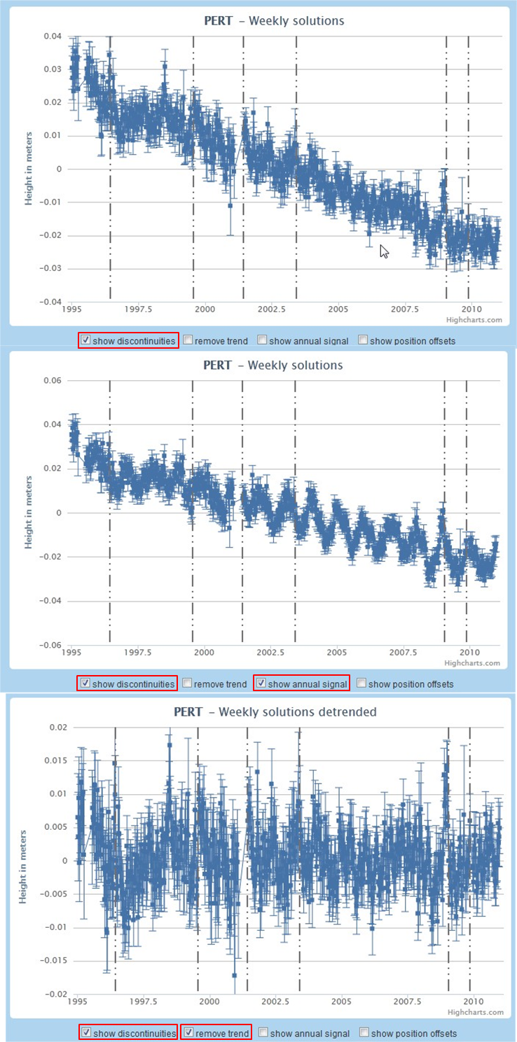
Most useful for the analysts, a new tool has been developed to display the GPS position time series. The user can now choose different options such as removing or not the linear trend (velocity), the seasonal signal (annual) or the detected offsets. Consistently, the GPS position data file that can be downloaded is in agreement with the chosen options of display. For example, if the "remove trend" option has been ticked, then the associated data file for downloading will not content the linear trend. The Figure on the right shows various possible options or combination of options for the Perth GPS station (click on the link to access that station and test the various options). This tool may provide substantial help to the analyst for a better understanding and interpretation of the observed signals at a particular station, its noise and overall quality.
Now published : IOC Manual & Guide 83 on Quality Control of in situ Sea Level Observations
The Intergovernmental Oceanographic Commission has just published a new manual on the quality control of sea level observations. The manual explores the need for quality control, appropriate methods for different forms of sea level data, metadata requirements, commonly used software packages, and investigates recent developments in automated quality control.
The manual (IOC Manual and Guide 83) is available from the IOC website. Simply click on the link : Quality Control of in situ Sea Level Observations : A Review and Progress towards Automated Quality Control.
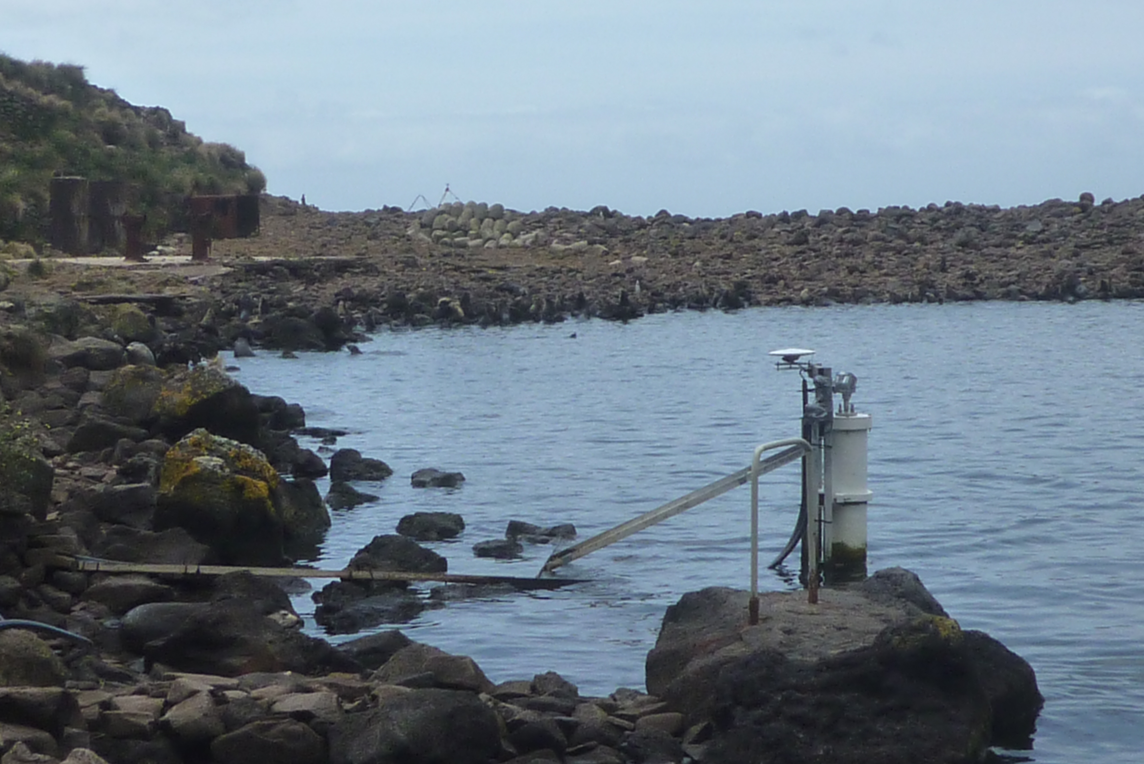
Permanent GPS station at the Saint-Paul island tide gauge, Indian Ocean
Researchers from the LEGOS joint research unit (UMR5566, CNRS/Toulouse) in collaboration with the DT/INSU (UPS 855 CNRS/Brest) have installed a permanent GPS station at the Saint-Paul Island (38°41’S - 77°31 E) in the South Indian Ocean, on the GLOSS tide gauge site during the last NIVMER campaign. This installation was done in the framework of the French ROSAME sea level network. It aims at better constraining and explaining the recent estimation of relative sea level trend observed at this site, which is not significantly different from zero.
Source: S. Calmant & Fichen, L., 2012.
NIVMER12 campaign.
Contact:
Laurent Testut (UMR LEGOS)
Tel. 05 61 33 27 85
Main results:
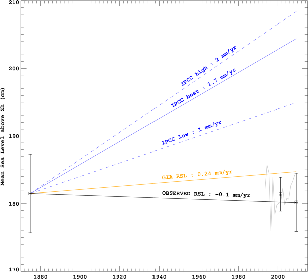
A data archaeology exercise was carried out on ancient sea level observations recorded during the transit of Venus across the Sun observed in 1874 from Saint-Paul Island, 38°41’S - 77°31 E, in the Southern Indian Ocean (Testut et al. 2010). Historical (1874) and recent (1994-2009) sea level observations were assembled into a consistent time series. A thorough check of the data and its precise geodetic connection to the same datum was only possible thanks to the recent installation of new technologies (GPS buoy and radar tide gauge sensor) and levelling campaigns. The estimated rate of relative sea level change, spanning the last 135 years at Saint-Paul, was not significantly different from zero (-0.1 ± 0.3 mm/yr), a value which could be reconciled with average global estimates of 1.7 mm/yr assuming the DORIS vertical velocity estimate at the nearby Amsterdam Island could be applied to correct for the land motion at the tide gauge (Altamimi and Collilieux, 2010). Considering the scarcity of long-term sea level data in the Southern Hemisphere, the exercise provides an invaluable additional observational constraint for further investigations of geographical sea level rise patterns.
Figure 1. (right) MSL estimates at Saint-Paul relative to the hydrographic zero for the historic observations (1874) and the recent observations (2009). The error bars indicate the uncertainty of the estimates. The grey curve is the annual mean altimetric sea level at Saint-Paul Island from AVISO product and the associated MSL is shown over the period as a rough guide. The orange line shows the GIA-induced relative sea level change rate, and the blue lines indicate the lower, upper and best global sea level trend estimate over the 20th century.
The data from the permanent GPS station that has been installed will provide an invaluable estimate of the Island vertical land movement. This information is critical to better interpret the rather astonishing result of no relative sea level elevation during the past 135 years. It will also be usefull for geodynamic studies on the dormant volcano of Saint-Paul island or on plate tectonics.
References:
– Altamimi Z. and X. Collilieux, 2010. Quality assessment of the IDS contribution to ITRF2008. Advances in Space Research, 45(12), 1500-1509.
– Testut L., B. Martin Miguez, G. Wöppelmann, P. Tiphaneau, N. Pouvreau, M. Karpytchev, 2010.The sea level at Saint-Paul, Southern Indian Ocean, from 1874 to the present. Journal of Geophysical Research, 115, C12028, doi:10.1029/2010JC006404.
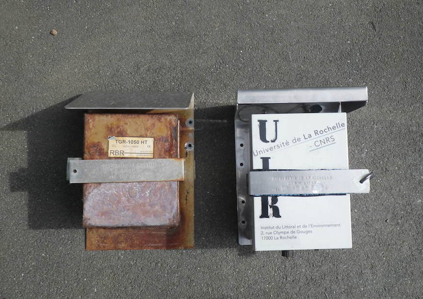
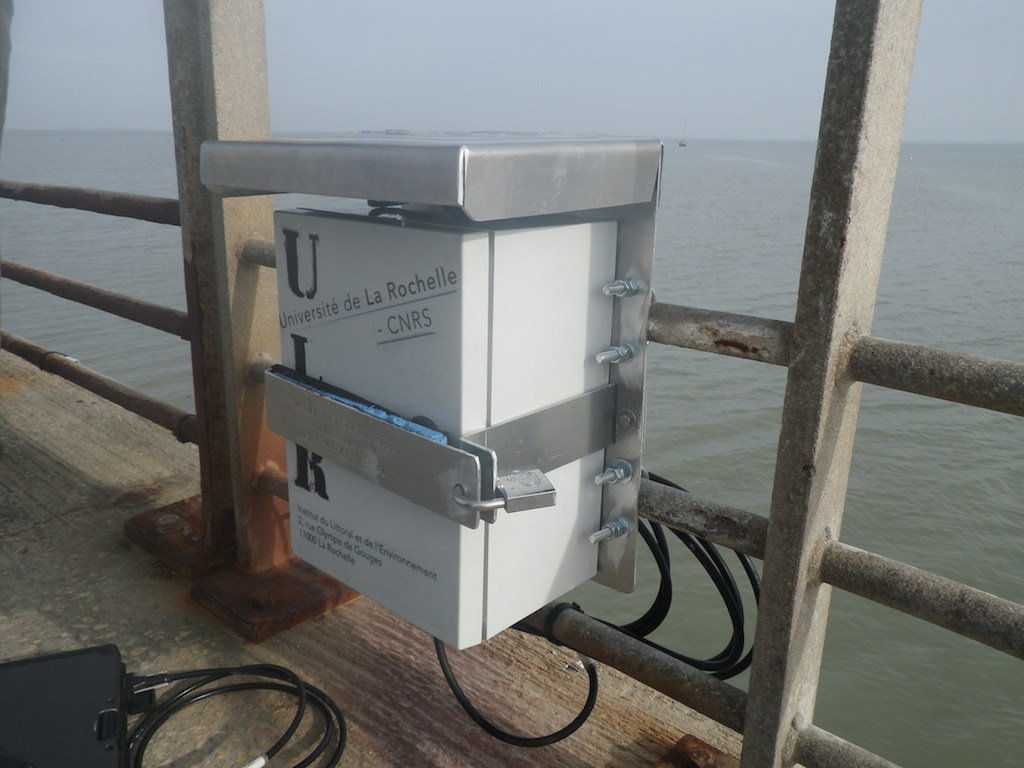
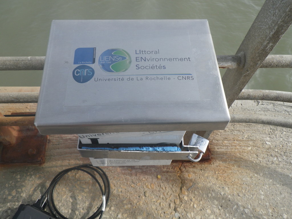
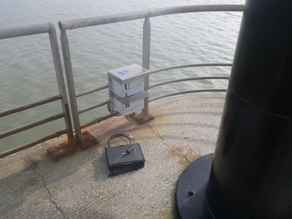
Pressure tide gauge now operational at the Aix Island (France)
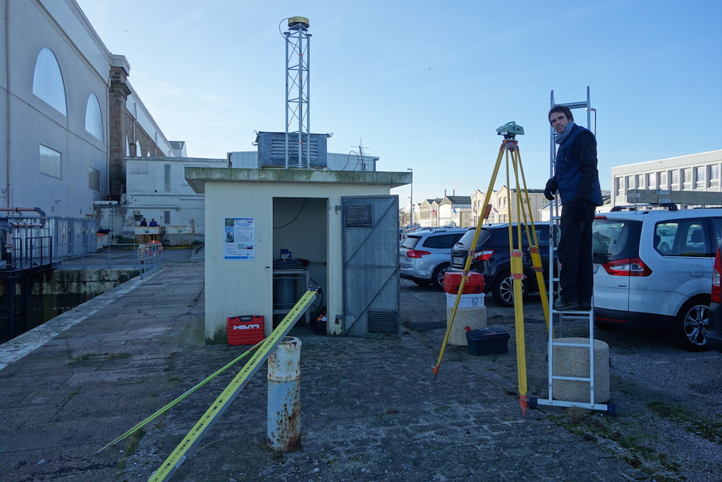
Monday 9th of March 2015, Clément Mayet and Etienne Poirier (University of La Rochelle, France) replaced the power unit of the pressure tide gauge (RBR) located at Aix Island, towards the end of the Barbotin jetty.
The operation took place seamless under good weather conditions. The tide gauge has been setup to record at a 1-min. sampling rate with an averaging time period of 40 seconds applied on the 1s raw data.
Contact :
Etienne Poirier (LIENSs - ULR/CNRS)
Tel. 05 46 45 83 94
Pictures from the University of La Rochelle:
Supplemental details:
This operation is timely with respect to the forthcoming exceptional spring tides on the 21st of March (equinoxes). The pressure gauge is an important component of the tide gauge station, as it supplements the primary tide gauge (radar gauge).
– Station webpage: Aix Island tide gauge
– 2015 exceptional spring tides (in French, SHOM): Further reading in French (SHOM)
Reorganisation of SONEL, Tide gauge data and the national liaison agency (REFMAR)
One of the reasons for which SONEL was founded was to federate the tide gauge networks that exist in France, and ensure that emerging networks were properly incorporated. Although the project was initiated by B. Simon at the SHOM (1999) it subsequently ran into numerous practical difficulties. Finally, it was partially implemented at the University of La Rochelle in 2003 (first on-line observations) and involved just the RONIM and ROSAME networks (cf. actes AEI 2004).
Today, the context is more favourable. The SHOM has been designated as the official national liaison for in situ sea level observations, together with the management and publication of the resulting data: see the "instruction permanente du Premier ministre n°863/SGMer du 20 avril 2010". Today it is tasked with :
– coordinating the gathering of sea level data produced by the organisations, agencies and public services that are within the competence of the state authorities ;
– Managing and archiving the data in real time and in delayed mode ;
– coordinating the publication in real time and in delayed mode of the data while ensuring that the conditions of accessibility and use comply with current legislation pertaining to information in the public domain.
To this end, the SHOM set up REFMAR (opposite) where users can find the data (raw in real time, and quality checked in delayed mode) from tide gauges on French territory. The fact that the SHOM has now taken on the tide gauge data aspect is excellent news and will enable the University of La Rochelle to concentrate its efforts on the other aspects of the SONEL system (see the architecture below). Moreover, it guarantees in particular that tide gauge data is managed by recognised specialists in the field, heirs to an experience which goes back to the first French tide gauge designed by the hydrographic engineer R. Chazallon in 1843.

The infrastructure of SONEL has been reorganised accordingly, particularly the Web and FTP servers of SONEL, in order to bring it into line with the architecture described in the diagram opposite. It incorporates REFMAR in a manner which is optimal and as transparent as possible for users. Numerous links have been created at every level of SONEL, in particular to achieve the initial aim of a synergy of the tide gauge and geodesic data.
In practice
There will be a transition phase which we will ensure to the best of our ability. During this transition phase users will find French tide gauge data both on the ftp.sonel.org and www.sonel.org servers and on the refmar.shom.fr servers . However, they should be aware that they would be well-advised to look for the data at its SHOM (REFMAR) source . The SHOM has both a recognised expertise and centuries-long experience in the field of tide gauges. Moreover, any new development or change in the French tide gauge network will immediately be incorporated in REFMAR given the mission with which it has been entrusted (cf. instruction permanente), and whatever the French tide gauge network (RONIM, ROSAME, etc.).
The source of high frequency data (REFMAR) will be identified and accessible from the SONEL Web pages of each station above the current visualisation and download sections during the transition phase (e.g., image on the left), although these visualisation and download sections will eventually disappear from the SONEL pages and only the link toward the source (REFMAR) will be available (e.g., image on the right). The images opposite provide an example of how this will look during the transition phase (which begins today) and going forward.
Agenda
– As from today, users of high frequency tide gauge data (hourly, 10min.,...) are invited to register on REFMAR.
– Beginning of March, the high frequency tide gauge data will only be accessible on REFMAR, initially on the current provisional server, and eventually on the permanent server, which is under validation (beginning of April).
Satellite Altimeter Calibration and Deformation Monitoring using GNSS
Papers are invited for a special topic issue of Advances in Space Research (ASR) entitled “Satellite Altimeter Calibration and Deformation Monitoring using GNSS”.
Global warming is a key scientific issue nowadays. Over the past decades, satellite altimetry has provided an unprecedented amount of data for monitoring sea level changes and thus global warming. Such scientific results however rely on a significant number of geophysical corrections as well as on continuous monitoring of the satellite altimeter performances using in-situ data. A few calibration sites around the world provide accurate calibration of satellite altimeters using different in-situ techniques involving monitoring of geodetic instruments close to the satellite tracks or at crossing points (platforms, tide gauges, buoys, etc.). While Global Navigation Satellite Systems, such as GPS, are key tools for geodetically monitoring the vertical velocity of such calibration sites, several scientific issues are still under consideration, as vertical positioning is still difficult to obtain in an absolute sense. Furthermore, new satellite altimeters, such as delay-Doppler, wide swath, etc., will soon provide new types of observations for sea-level monitoring and allowing altimetry to be closer at the coastal regions, for which new types of calibration could be foreseen.

This Special Issue is open to all scientists discussing new scientific challenges in satellite altimeter calibration (technical aspects related to the altimeter functioning, description of current calibration sites and current techniques, or global satellite calibration using networks of tide gauges or GNSS networks), as well as current limitations in deformation monitoring (monitoring of the vertical, use of regional and continuously-operating GNSS networks, reference issues when expressing vertical velocities in global, regional or local frames). Paper addressing topics related to natural hazards would also be welcome.
Papers must be submitted electronically through the EES/Elsevier Web system at http://ees.elsevier.com/asr. To ensure that all manuscripts are correctly identified for inclusion into the Special Issue, authors must select “Special Issue: Altimetry Calibration”, when they reach the “Article Type” step in the submission process.
Submitted papers must be written in English and should indicate full affiliation addresses for all authors. All manuscripts will be subject to a standard peer-review process, including at least two independent reviewers. There are no page limits, but the length of the paper should be appropriate to the scientific material being presented. Manuscripts should follow the general format used in ASR:
(http://www.elsevier.com/wps/find/journaldescription.cws_home/644/authorinstructions). The deadline for submission is 15 January 2012.
Manuscripts will be accepted on a paper-by-paper basis and available on-line with a DOI a few days after acceptance. Contributors to this issue will have an opportunity to purchase individual issues once the issue is finalized. All articles will be typeset at no cost to the author, while a nominal fee will be charged to the authors for color figures in print, but not in the electronic version.
Dr. Pascal Willis () is the Guest Editor for this Special Issue. Authors will be regularly informed on the progress of this Special Issue by email until its final publication. Questions can be directed to Pascal Willis or to the Co-Editor for Special Issues, Dr. Peggy Ann Shea (sssrc@msn.com).
The Global Sea Level Observing System (GLOSS) programme updates its implementation plan
The Intergovernmental Oceanographic Commission (IOC) of the UNESCO publishes the new implementation plan of the Global Sea Level Observing System (GLOSS). The updated implementation plan copes with the new challenges in the field of monitoring sea level for a better understanding of the processes behind sea level rise and variability.
Source :
Technical Secretary for the Global Sea Level Observing System (COI/UNESCO).
Contact :
Guy Wöppelmann
Chair of the GLOSS Science Steering Group
Tel. +33 5 46 45 86 13
Briefly :
The implementation plan provides an overview of the GLOSS programme and its current status as well as a description of the scientific and operational requirements raised over the past years by advisory groups and panels.
The focus remains the GLOSS Core Network (GCN) of stations and the datasets that result from this network. Nonetheless, it is worth highlighting that the new plan calls for two significant upgrades to the GCN motivated by scientific and operational requirements :
– All GCN stations are required to report data in near-real time, which will be tracked at a Sea-level Station Monitoring Facility. This will involve upgrades in power, data acquisition platforms, and communication packages. However, these upgrades are cost-effective in terms of the benefits that a real-time system will provide for ocean monitoring and improved station performance due to early detection of station malfunctions.
– Continuous measurements of Global Navigation Satellite Systems (GNSS), in particular the U.S. Global Positioning System (GPS), the Russian GLONASS, or the newly established European GALILEO, or equivalent systems, in the vicinity of the primary tide gauge benchmark (TGBM) are required for all GCN stations. This upgrade will support satellite altimetry calibration and research efforts aimed at determining rates of geocentric global sea-level rise as well as regional changes in sea level. In this line, SONEL plays the role of GNSS at tide gauges data assembly center for GLOSS and provides information on its status through a web-based service. (See the dedicated SONEL webpages).
Further reading :
– Link to the GLOSS implementation plan in PDF format
– Link to the official website of GLOSS
Twelfth Session of the GLOSS Group of Experts, Unesco, Paris, 7-11 November 2011
The next meeting of the global sea-level observing programme (GLOSS) is taking place at Unesco, Paris, 9-11 November 2011.
Two workshops will precede the event, respectively dealing with:
– Storm surge monitoring and extreme sea levels, and the need for high-quality real-time sea level data (7-8 November 2011);
– Space-based methods for vertical tide gauge control (afternoon of 8 November and morning of 9 November 2011).
The GLOSS group of experts meeting itself will take place from 9 to 11 November 2011. The agendas are in the process of elaboration (See 1st link below).
Further details :
– on these meetings
– on the GLOSS programme
Workshop at the Collège de France, Paris, 10-11 June 2013
Within the framework of the annual chair "Sustainable Development - Environment, Energy and Society", a workshop is organised by Anny Cazenave, Professor at the Collège de France, on the theme : " Climate change and sea level rise ; Coastal vulnerability and societal impacts ".
The workshop aims at presenting the most recent updates about sea level observations and projections for the next few decades, highlighting the importance of the regional variability. A synthesis of the various phenomena causing shoreline modifications on interannual to multidecadal time scales will be presented and the causes of observed shoreline erosion for the past few decades will be discussed. More focused presentations about impacts of sea level rise will be provided for a number of coastal regions (Netherlands, Asian deltas, tropical atolls, Quebec and France), with focus on economical and societal consequences as well as on potential adaptation strategies.
Source :
Prof. Anny Cazenave
Chair fellowship 2012-2013
Collège de France
Important details :
. The presentations and discussions will be . Don’t hesitate to book your agendas. The workshop will take place at the Collège de France, Paris, 10-11 June 2013. Click on the following link or on the image above to download the workshop announcement containing the details of the programme.
Further reading :
Link to the Collège de France, this chair and its programme
WORKSHOP GLOBAL AND REGIONAL SEA LEVEL VARIABILITY AND CHANGE

10-12 JUNE 2015
MALLORCA, SPAIN
https://slrmallorca.wordpress.com/
The objectives of the workshop are:
– Evaluate an integrated view of the current state-of-knowledge with the most up to date outcomes.
– Identify gaps and unresolved questions in any aspect of sea level science and design the paths for future research.
– Foster international collaborations among researchers of complementary disciplines.
7 Sessions:
- Paleo Sea Level
- Vertical Land Movements
- Mean Sea Level Observations and Processes
- Modelling Sea Level Changes
- Sea Level Extremes
- Coastal Impacts of Sea Level Changes
- Special session on Mediterranean sea level
Comitee
Marta Marcos, IMEA (UIB-CSIC), Mallorca, Spain
Francisco M. Calafat, National Oceanography Centre, Southampton, UK
Sonke Dangendorf, Research Institute for Water and Environment (fwu),University of Siegen, Germany
Ivan Haigh, University of Southampton, UK,
Registration will be open in March 2015
Call for abstract will be open in January 1st until March 8th 2015


