Progress report on the survey
- 29 december
1999 -
Guy Wöppelmann, C. Boucher, C. Bruyninx, P. Woodworth
In the early of october 1999, we started a survey within various geodetic, hydrographic and oceanographic communities. The aim of this survey is simply to identify the existing permanent GPS stations which are close to tide gauges (up to approximately 10 km), as well as already planned GPS stations which fulfill this vicinity criteria.
The survey was initiated by e-mail through the following mailing lists : IGS, ITRF, EUREF and GLOSS. It is carried out with the support of individuals involved in these communities and interested in the continuous positioning of tide gauges : C. Boucher (IERS, IGS), C. Bruyninx (EUREF) and P. Woodworth (GLOSS, PSMSL).
The survey is quite successful thanks to the numerous responses we have received. We thank here all the contributing colleagues. The only information that we asked for, in our original mail, was the name and approximate geographic coordinates of the permanent GPS station close to a tide gauge. The objective was to get an idea on the current status of the geodetic monitoring of tide gauges with GPS. We then complete the information received for each station with some codes. These codes represent in principle an official commitment to a specific network. Thus, they give an idea of the interest of each station and possible access to the data.
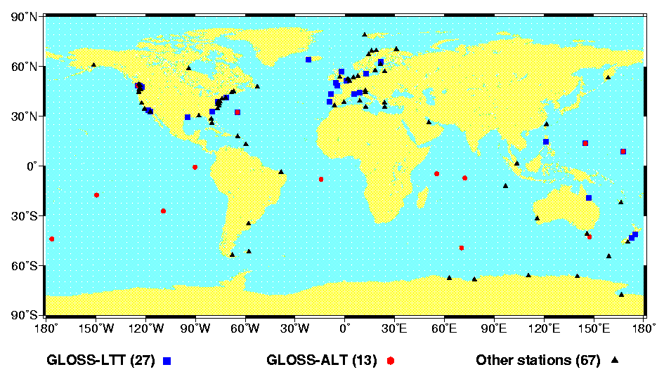
In brief, as much as 103 permanent GPS stations have been identified as operating near a tide gauge. 5 more stations should be added to this number if we consider closed seas and lakes. 10 more stations are already planned.
These stations are distributed around the world, although the distribution is clearly biased towards the northern hemisphere. A quick inspection shows that 40 tide gauge / GPS sites are committed to GLOSS,
The next map highlights the 'Global' IGS stations. The label 'Global' means that the data of these stations (31 at present) is processed by at least three IGS Analysis Centers (AC), one of them established on a different continent. Consequently, for 'Global' stations,
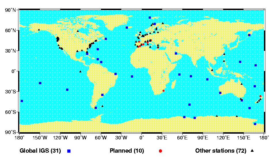
Other stations of the survey may belong to the IGS network too, but are labelled as 'Tracking' IGS stations. 'Tracking' stations may not be processed by an IGS Analysis Center (AC) or Associate Analysis Center (AAC), depending on the centers processing strategy and own interests (orbits, ionosphere...). At least, their data may be accessible at a global or regional IGS data center.
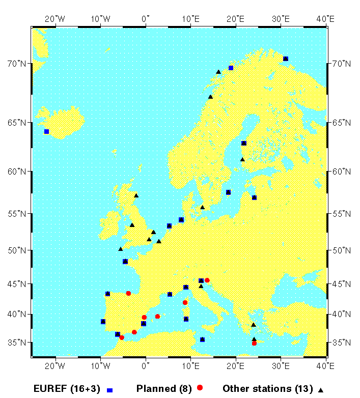
The last map shows the situation in Europe, where EUREF act as a densification structure of IGS. We notice that not all the permanent GPS stations of our survey are part of EUREF, nor IGS. Thus, at present, 13 out of the 32 operational GPS / tide gauge stations do not come through the EUREF or IGS data fluxes in Europe. However, 19 are processed within EUREF yet (note : 3 are 'Global' IGS stations).
The table below is a view of the information collected and stored in a simple database which was set up for the survey. Columns 2,3,4 are the name, longitude and latitude of the GPS station (the only information actually requested in the survey). The first column is an internal database index and the other columns are
Click on the link to access the table
Please, don't hesitate to update or correct the information of this table by sending an e-mail to .
In order to keep an updated list of permanent GPS receivers operating at tide gauges within ~10 km, we plan to set up an 'html/php3' formular. The table above could then be updated through internet (after a previous crosscheck with the database). Of course, people could still proceed as formerly by sending an e-mail to .
The PSMSL/IGS workshop in 1997 (Pasadena) recommended the setting up of special RNAAC's within IGS. These RNAAC's aim to perform the necessary GPS data processing from tide gauge sites. The IGS distributed processing strategy (GNAAC's) would then take care of the reference consistency, in cooperation with IERS, to produce the expected final results (height time series and velocity estimates expressed in the ITRF).
A prerequisite for such RNAAC's to succeed in their analyses is the grouping of the relevant GPS observation sets. The results of our survey indicate that these datasets are either disseminated through various regional and global data centers, or lacking at these identified centers. Thus, a dedicated 'regional' data center would be helpful, even essential.
It seems well recognized now that the tide gauge special RNAAC's should be connected to some scientific investigation group. Conversely, the related data grouping should be part of a service structure that is more likely able to assure a long term archiving.
The long term archiving (and reprocessing) is indeed an important function for the sea level trend studies as there still remain uncertainties on time-dependent systematic errors from GPS positioning (e.g. antenna phase center variations, troposphere, frame stability...).
On the other hand, data disponibility at the foreseen dedicated regional data center may not be as critical as for IGS standard products (satellite orbits and clocks...). Mean sea level time series from PSMSL are based on monthly and annual values. Thus, a time lag of 1-2 months between measurement and disponibility at the data center may be quite acceptable for special RNAAC's which are interested in long term sea level trend studies. The key issue for this application is to avoid lacks in the time series. Thus, communication difficulties at remote stations may be accepted and managed in the data fluxes.
Some colleagues have expressed their interest to get more information on the stations of the survey, like for instance the data span for the tide gauge or GPS, etc. Extended auxiliary information may already be accessible through the relevant databases of PSMSL, GLOSS or IGS. The information is actually rather disseminated. However, plans are currently discussed at some european (EOSS) and international (PSMSL/IGS) working groups for the establishment of synergetic tide gauge and geodetic databases.
IGS-PSMSL [1997] : Proceedings of the workshop on methods for monitoring sea level, March 17-18, 1997, Pasadena (California), 202 pp.
M. Bevis [1998] : "Continuous GPS positioning of tide gauges: some preliminary considerations". Report to the IGS. GLOSS Bulletin Nr. 6.