Progress report on the survey
- April 20, 2001 -
G. Wöppelmann, C. Boucher, M. Bevis, C. Bruyninx, P. Woodworth
In order to get a better idea about the status and opportunities of continuous GPS positioning of tide gauges, a survey has been carried out within the IGS, ITRF, EUREF and GLOSS mailing lists in October 1999. The survey aimed at identifying the existing permanent GPS stations which are close to tide gauges (up to approximately 10 km). Planned GPS stations (which fulfill this vicinity criteria) were also welcomed. A progress report was written in December 1999 (Click on the link to access the report).
Today, an updated version seems opportune. Although the requested information was limited (the only information that was asked, was the name and approximate geographic coordinates of the permanent GPS station close to a tide gauge), it might give an idea of (i) the interest of each station and (ii) the data access and availability. The report might also provide a modest starting point for technical discussions (GLOSS Group of Experts, IGS pilot project TIGA which has been approved by the IGS Governing Board in April 2001...).
The results of the survey are stored in a database whose contents can be browsed and searched through a web interface. Go to the following URL to get a view of the survey table :
The main view is ordered by GPS station name and displays 50 rows at a time. The 'List all' link scrolls the view to the next 50 rows, a.s.o. The 'Search' link presents a form that can be filled up with criterias. A subset of the data matching these will than be displayed.
Few explanations on the table colums. Columns 2,3,4 are the name, longitude and latitude of the GPS station (the only information actually requested in the survey). The first column is an internal database index and the other ones are
The codes represent in principle an official commitment to a specific network. They give an idea of the quality, interest and data availability.
The following tables (you have to click on the links to access them) are simple text tables produced for the report in order to outline certain information.
General :
GLOSS related information :
Sorted by distance to the tide gauge :
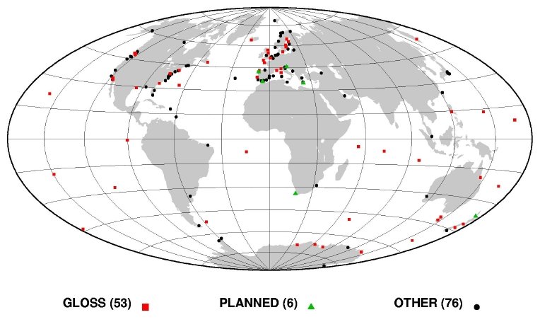
A total of 129 operational permanent GPS stations less than 10 km away from a tide gauge have been identified. In addition, 6 stations meeting this criterion are planned. Overall, the stations are distributed worldwide (see figure 1), though not evenly. There is a bias towards the Northern hemisphere. The geographical bias is variable but is always worse when looking at restricted set of stations belonging to a particular application or technical theme (GLOSS, less than 1 km,... see figures 2 and 3 for instance).
Figure 1
53 tide gauge / GPS sites are committed to GLOSS,
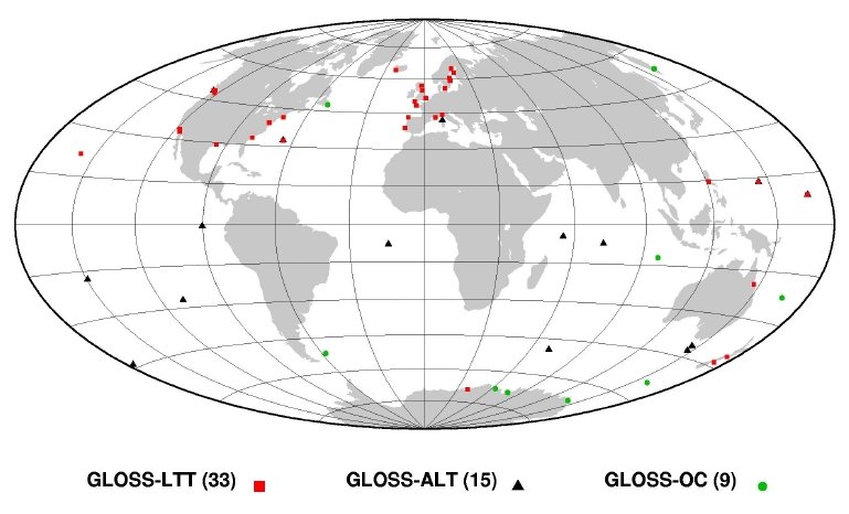
Figure 2
It is quite interesting to have a look at the distance between the GPS antenna and the tide gauge. An extended survey has shown that 34 GPS stations are less than 1000 meters away from the tide gauge (10 out of 34 are GLOSS ones, see map below), 4 are between 1 and 3 km and 20 are between 3 and 10 km. This feature is critical for some applications like GLOSS-LTT : In no circumstances can it be assumed that even relatively close sites are not moving differentially at the mm/year level.
Therefore, frequent levellings (at least annually) are required over a long period of time (10-20 years). Experience shows that these regular levelling surveys are often neglected over time, in particular if the distance involved is more than a few hundred metres. Where the distance is more than 1 km, it is unlikely anyone will perform a levelling tie on a regular basis. Moreover, the levelling error can become a significant part of the total error budget. So, stations more than 1 km away cannot be considered 'nearly collocated' in the practical sense, though they may still be of interest for other applications (GLOSS-OC...).
It is important to say that the survey is far from complete since the distance information is missing for 65 stations...
Figure 3
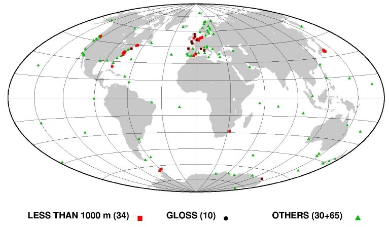
Figure 4 map highlights the Global IGS stations. Global meaning among other things that their observations are processed by at least three IGS Analysis Centers (AC). Consequently, for Global stations,
Figure 4
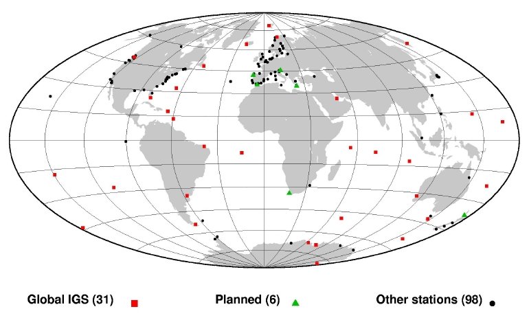
The survey lists other IGS stations labelled as 'Tracking' IGS stations. 'Tracking' stations may not be processed by an IGS Analysis Center (AC) or Associate Analysis Center (AAC), depending on their own processing strategy and interests (orbits, ionosphere...). Still, their data is accessible at a global or regional IGS data center.
Colleagues have expressed their interest in us collecting more information on the stations of the survey. Short answer is : It depends on you to provide the relevant information that may be useful for our investigations (see section 3.2 for plans) and to keep the data updated. So, please, don't hesitate to update or correct the information of this table by sending an e-mail to Guy Wöppelmann.
There are plans within the IGS for setting up dedicated RNAAC's to process GPS data at tide gauges. The IGS densification project would then take care of the reference consistency through its distributed processing strategy (GNAAC's), in cooperation with IERS, in order to produce the final results (height time series and velocity estimates expressed in the ITRF). These ideas have been compiled and put into action in the TIGA IGS pilot project, recently started, its main objective is the continuous GPS monitoring of tide gauge benchmarks.
A prerequisite for such RNAAC's to succeed in their analyses is the availability of the relevant GPS observation sets. Our survey indicates that these datasets are either disseminated through various regional and global data centers or not distributed at all. Thus, a dedicated one stop shop 'regional' data center would be very helpful to TIGA.
In order to review stations that might be included, more information is needed, for instance :
IGS-PSMSL [1997] : Proceedings of the workshop on methods for monitoring sea level, March 17-18, 1997, Pasadena (California), 202 pp.
M. Bevis [1998] : "Continuous GPS positioning of tide gauges : some preliminary considerations". Report to the IGS. GLOSS Bulletin Nr. 6.
M. Bevis, W. Scherer and M. Merrifield [2000] : Technical issues and recommendations related to the installation of continuous GPS stations at tide gauges.
CGPS@TG Working Group : CGPS@TG Website - A technical forum on continuous GPS monitoring of tide gauges.