
NEWLYN
Contributing agency

Station summaryNEWL


| IGS-type acronym : | NEWL |
| Latitude : | 50.10300064 |
| Longitude : | -5.54278994 |
| Installed date : | 1998-09-30 |
| Decommissioned date : | 2022-10-24 |
| Country : | UK |
| City: | NEWLYN |
| Station status : | Decommissioned (white and red cross) |
| Distance to Tide Gauge (m) : | 5 |
| Domes Nr.: | 13273M103 |
| Station operator: | Unknown |
| IGS-like station form : |
GPS position times seriesNEWL
(Reference epoch: )
| M | Material change or malfunction |
| E | Earthquake |
| RF | Reference Frame change |
| U | Unknown |
| NA | Not available |
| Position discontinuity | |
| Velocity discontinuity |
Data available at SONELNEWL
Quality plots on RINEX filesNEWL
 |
 |
Plots generated using software developed with the EPN team at ROB |
| Observations & tracking performance | Satellite tracking |
 (this operation may take 20 to 45s)
The satellite tracking graph has been calculated for all stations for the first day of each month. If you wish to have a graph for another date, choose the 'Calculate a specific date' option.
Co-located instrumentsNEWL
- Tide gauge : NEWLYN (NEWLY)
Leveling & DatumsNEWL
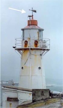
Photo albumNEWL
BibliographyNEWL
If you have a relevant reference to suggest, please send-us an e-mail : sonel@sonel.org-
 Araujo, Pugh, 2008. Sea Levels at Newlyn 1915–2005: Analysis of Trends for Future Flooding Risks. Journal of Coastal Research.

-
Bradshaw, Woodworth et al., 2015. A Century of Sea Level Measurements at Newlyn, Southwest England.

-
Woodworth, Hibbert, 2015. Sea-level monitoring in the British verseas Territories. Journal of Operational Oceanography.
Log bookNEWL
[EUREFmail-09738] - 2019-02-13 (14/02/2019)
NEWL (Newlyn, Great Britain) Trimble NetR9 receiver has been updated from 5.01 to 5.37 on 2019-02-18 and a site log has been submitted to EUREF.
However, tracking problems that started on 2018 344 still persist until a site visit can be made to identify the cause of these problems.
[EUREFmail-7019] - 2013-06-25 (25/06/2013)
Data from our NEWL station has been unavailable for some time (since 2012-12-25) due to a failed receiver/antenna and a lack of funding to replace these.
I am pleased to announce that through some additional funding for our British Isles continuous GNSS Facility (BIGF) provided by our Natural Environment Research Council (NERC) we have now been able to procure some new equipment, which was installed on 2013-05-21.


