LEVELING OF TONGA
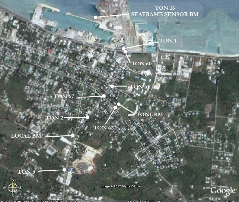
Benchmark positionning related to the tide gauge station

Benchmarks description table
Benchmarks vertical positionning diagram
Reference:
Leveling evolution
| Stand point | TON1 | TON1 | TON1 | TON1 | TON1 | TON1 | TON1 | TON1 | TONGBM | ||
|---|---|---|---|---|---|---|---|---|---|---|---|
| End point | TON2 | TON3 | TON60 | TON61 | TON62 | TONGBM | TON15 | TON16 | TONG | ||
| Distance (m) | ---- | ---- | ---- | ---- | ---- | ---- | ---- | ---- | ---- | ||
| Height difference (m) | Campaign 12 | 2008-10-15 | -0.3201 ± 0.001 | 6.5051 ± 0.001 | 0.3235 ± 0.001 | -0.0268 ± 0.001 | 0.0021 ± 0.001 | 0.8644 ± 0.001 | 1.1528 ± 0.001 | --- | 0.9662 ± 0.001 |
| Campaign 11 | 2007-06-15 | -0.3201 ± 0.001 | 6.5053 ± 0.001 | 0.3241 ± 0.001 | -0.0266 ± 0.001 | 0.0022 ± 0.001 | 0.8646 ± 0.001 | 1.1537 ± 0.001 | 2.7774 ± 0.001 | 0.9662 ± 0.001 | |
| Campaign 10 | 2005-09-15 | -0.3202 ± 0.001 | 6.5046 ± 0.001 | 0.3311 ± 0.001 | -0.0265 ± 0.001 | 0.0017 ± 0.001 | 0.8642 ± 0.001 | 1.1506 ± 0.001 | 2.7696 ± 0.001 | 0.9662 ± 0.001 | |
| Campaign 9 | 2005-06-15 | -0.3205 ± 0.001 | 6.5042 ± 0.001 | 0.3311 ± 0.001 | -0.0273 ± 0.001 | 0.0010 ± 0.001 | 0.8635 ± 0.001 | 1.1513 ± 0.001 | 2.7705 ± 0.001 | 0.9662 ± 0.001 | |
| Campaign 8 | 2003-06-15 | -0.3208 ± 0.001 | 6.5043 ± 0.001 | 0.3314 ± 0.001 | -0.0273 ± 0.001 | 0.0008 ± 0.001 | 0.8632 ± 0.001 | 1.1514 ± 0.001 | 2.7701 ± 0.001 | 0.9662 ± 0.001 | |
| Campaign 7 | 2002-06-15 | -0.3205 ± 0.001 | 6.5041 ± 0.001 | 0.3318 ± 0.001 | -0.0272 ± 0.001 | 0.0012 ± 0.001 | 0.8640 ± 0.001 | 1.1517 ± 0.001 | 2.7710 ± 0.001 | 0.9662 ± 0.001 | |
| Campaign 6 | 2000-06-15 | -0.3218 ± 0.001 | 6.5025 ± 0.001 | --- | --- | --- | --- | 1.1509 ± 0.001 | 2.7714 ± 0.001 | --- | |
| Campaign 5 | 1999-06-15 | -0.3207 ± 0.001 | 6.5037 ± 0.001 | --- | --- | --- | --- | 1.1512 ± 0.001 | 2.7715 ± 0.001 | --- | |
| Campaign 4 | 1997-06-15 | -0.3212 ± 0.001 | 6.5031 ± 0.001 | --- | --- | --- | --- | 1.1515 ± 0.001 | 2.7710 ± 0.001 | --- | |
| Campaign 3 | 1996-06-15 | -0.3213 ± 0.001 | 6.5026 ± 0.001 | --- | --- | --- | --- | 1.1530 ± 0.001 | 2.7803 ± 0.001 | --- | |
| Campaign 2 | 1995-06-15 | -0.3205 ± 0.001 | 6.5038 ± 0.001 | --- | --- | --- | --- | 1.1521 ± 0.001 | 2.7775 ± 0.001 | --- | |
| Campaign 1 | 1994-06-15 | -0.3208 ± 0.001 | 6.5031 ± 0.001 | --- | --- | --- | --- | 1.1524 ± 0.001 | 2.7778 ± 0.001 | --- | |
| Height difference evolution graph |  |  |  |  |  |  |  |  |  | ||
Download leveling data
TIDE GAUGE LOCAL LEVELING NETWORK DATA OF STATION TONGA
-----------------------------------------------------------------------------------------------------
Benchmark Lat. Long. Height Year of determination St.dev Distance_to_TG
10chr (°) 14chr (°) 14chr (m) 10chr 22chr (m)10chr (m) 10chr
-----------------------------------------------------------------------------------------------------
TON1 ---- ---- 8.000 2008 0.00000 ----
TON2 ---- ---- 7.680 2008 0.00100 ----
TON3 ---- ---- 14.505 2008 0.00100 ----
TON60 ---- ---- 8.323 2008 0.00100 ----
TON61 ---- ---- 7.973 2008 0.00100 ----
TONGBM ---- ---- 8.864 2008 0.00100 ----
TON15 ---- ---- 9.153 2008 0.00100 ----
TON16 ---- ---- 10.777 2007 0.00100 ----
TON62 ---- ---- 8.002 2008 0.00100 ----
TONG ---- ---- 9.831 2008 0.00200 ----
Co-located instruments
- GPS : TONGA (TONG)
- Tide Gauge : NUKU'ALOFA B (TONTG)
- GPS : Tonga Tide Gauge (TOGT)
Photo album