


Geodetic monitoring of tide gauge benchmarks with GPS
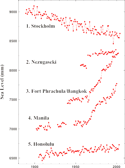
In 2001, the International GPS Service for Geodynamics (IGS, which is today known as the International GNSS Service) established a pilot project called TIGA (the first letters of tide gauge) to meet the needs expressed by researchers from as early as the 1980s, particularly those involved in the GLOSS programme. These needs have evolved with the advent of satellite radar altimétry and the Franco-American mission Topex/Poseidon (1992-2005). They include: the calibration of radar altimeters by tide gauges whose data are expressed in the same geocentric terrestrial reference frame as the radar altimetry satellites using GPS stations; and the continuing need to separate the vertical land movements from the climate contributions of the long term sea-level variations in the tide gauge records. The goal of TIGA is therefore to determine worlwide tide gauge positions and time series of positions with the highest possible quality of metrology and over a long time span in order to deduce the vertical movements of the land on which they are placed along the coast. The image opposite taken from the PSMSL illustrates the variety and amplitude of the land movements that can affect the stability of tide gauges.
The IGS appears to be the appropriate framework to provide the infrastructure in terms of service and research that is required to meet the needs of scientists working on the field of the geodesic determination of the positions and movements of coastal tide gauges on a global and international scale. In particular, it brings together the researchers and engineers of the main Space agencies and bodies involved in the area of GNSS (the Jet Propulsion Laboratory of NASA, ESA, MIT, CNES etc.).
The main components identified in this infrastructure are: (i) operational stations having a co-located tide gauge and GPS; (ii) specialised GPS@TG data centres; (iii) dedicated GPS data analysis centres for tide gauge benchmark fixing and monitoring; and (iv) a centre for verifying, evaluating and combining the results of individual analysis centres (component iii) by cross-comparisons.
Nine years later, the success of the pilot project is such that it has turned into a permanent service (Working Group) of the IGS in 2010.
Further information on the web site of the project (hosted by GFZ, Potsdam).


