


GNSS
Which GNSS stations?
-
Click on legend to show/hide stations groups
Below is a list of the GNSS data providers ordered by country. For each provider, it gives the acronym of the associated GNSS stations. Note that the work is under progress to have a complete list. However, do not hesitate to contact us to keep it updated.
E-mail: sonel@sonel.org
| COUNTRY (67) | PROVIDER (210) | ACRONYM | GNSS stations (1008) |
|---|---|---|---|
| Institut National de l'Information Géographique et Forestière | IGN | (32) | |
| Service Hydrographique et Océanographique de la Marine | SHOM | (5) | |
| National Oceanic and Atmospheric Administration | NOAA | (9) | |
| Institut Polaire Français Paul Emile Victor | IPEV | (4) | |
| Bundesanstalt für Gewässerkunde | BAFG | (41) | |
| Institut de Physique du Globe de Paris | IPGP | (5) | |
| Centro GNSS de Canarias | CGC | (7) | |
| Centre d'Etudes Techniques Maritimes et Fluviales | CETMEF | (7) | |
| National Oceanography Centre | NOC | (6) | |
| Instituto de Estadística y Cartografía de Andalucía | IECA | (6) | |
| Gipuzkoako Foru Aldundia | GFA | (1) | |
| Korea Astronomy and Space Science Institute | KASI | (3) | |
| Centre National de la Recherche Scientifique | CNRS | (19) | |
| ASG-EUPOS | ASG-EUPOS | (5) | |
| Ordnance Survey Ireland | OSI | (3) | |
| TERIA | TERIA | (20) | |
| Ordnance Survey Geodesy and Positioning | OS | (5) | |
| Kadaster | NSGI | (11) | |
| Diputacion Foral de Vizcaya | DFV | (2) | |
| Real Instituto y Observatorio de la Armada | RIOA | (3) | |
| Servicio de Informacion Territorial de las Islas Baleares | SITIB | (2) | |
| Observatoire de Recherche Méditerranéen de l'Environnement | OREME | (1) | |
| Marine Institute | MI | (2) | |
| Agency for Data Supply and Infrastructure | SDFI | (17) | |
| The Canadian High Arctic Ionospheric Network | CHAIN | (1) | |
| Laboratoire de l'Atmosphère et des Cyclones | LACY | (1) | |
| Digitaal Vlaanderen | DV | (6) | |
| British Columbia Active Control System | BCACS | (3) | |
| ARG | Instituto Geografica Nacional de la Republica Argentina | IGNRA | (9) |
| ARG | Instituto Nacional de Prevención Sísmica | INPRES | (1) |
| ARG | Estacion Astronomica Rio Grande | EARG | (3) |
| AUS | Geoscience Australia | GA | (50) |
| AUS | Department of Environment & Primary Industries | DEPI | (3) |
| AUS | LANDGATE | LANDGATE | (5) |
| AUS | Department Infrastructure, Planning & Logistics | DIPL | (2) |
| AUS | IPS Radio and Space Services - Australia Bureau of Meteorology | IPS | (1) |
| AUS | Australian Surveying & Land Information Group | AUSLIG | (1) |
| AUS | Curtin University | Curtin University | (1) |
| BEL | Royal Observatory of Belgium | ROB | (1) |
| BEN | Institut Geographique National du Benin | IGN-BJ | (1) |
| BOL | INSTITUTO GEOGRAFICO MILITAR DE BOLIVIA | IGM-Bo | (1) |
| BRA | Instituto Brasileiro de Geografia e Estatística | IBGE | (28) |
| BRA | Instituto Nacional de Pesquisas Espaciais | INPE | (1) |
| BRB | Coastal Zone Management Unit | CZMU | (2) |
| CAN | National Resources Canada | NRCan | (29) |
| CAN | Geological Survey of Canada | GSC | (5) |
| CAN | SERVICE NOVA SCOTIA | SNS | (4) |
| CAN | Dept. Internal Services | ISD | (1) |
| CHE | Swiss Federal Office of Topography | SWISSTOPO | (1) |
| CHL | Departamento de Geofísica, Centro Sismologico Nacional, Univ. de Chile | DGF - CSN | (1) |
| CHL | Center for Space Studies | CEC | (2) |
| CHL | Universidad de Concepcion | UdeC | (1) |
| CHL | Universidad de Antofagasta | UANTOF | (1) |
| CHL | Universidad de Santiago de Chile | USACH | (1) |
| COL | Instituto Geografico Agustin Codazzi | IGAC | (4) |
| COL | Servicio Geologico Colombiano | SGC | (1) |
| CPV | Instituto Nacional de Meteorologia e Geofisica | INMG | (1) |
| CRI | Registro Nacional Republica Costa Rica | RNP | (3) |
| CYM | Cayman Land Info | CAYMAN | (1) |
| DEU | Deutsches GeoForschungsZentrum | GFZ | (22) |
| DEU | Deutsches Geodätisches Forschungsinstitut | DGFI | (2) |
| DEU | Bundesamt für Kartographie und Geodäsie | BKG | (21) |
| DNK | DTU Space National Space Institute | DTU-Space | (12) |
| DNK | Danish Geodata Agency | GST | (1) |
| DOM | Universidad Nacional Pedro Henriquez Ureña | UNPHU | (3) |
| ECU | Instituto Geografico Militar Ecuador | IGM_EC | (2) |
| ECU | Instituto Geofisico de Escuela Politécnica Nacional | IGEPN | (4) |
| EGY | Centre d'Etudes Alexandrines | CEAlex | (2) |
| ESP | Instituto Geografico Nacional | IGNE | (40) |
| ESP | Puertos del Estado | PDE | (9) |
| ESP | Instituto Espanol de Oceanografia | IEO | (1) |
| ESP | Geodetic Department Universtidad de Cantabria | UC | (1) |
| ESP | Department of Applied Geodesy - Aranzadi Society of Sciences | ADAG | (1) |
| EST | Estonian Land Board | ELB | (15) |
| FIN | Finnish Geospatial Research Institute, National Land Survey of Finland | FGI-NLS | (5) |
| FRA | Laboratoire d'Etudes en Geophysique et Oceanographie Spatiale | LEGOS | (6) |
| FRA | Direction des Infrastructures, de la Topographie et des Transports Terrestres | DITTT | (6) |
| FRA | Port Autonome de Nantes - Saint-Nazaire | PANSN | (1) |
| FRA | Laboratoire de Géologie de l’Ecole normale supérieure | GEOL ENS | (3) |
| FRA | Centre National d"Etudes Spatiales | CNES | (19) |
| FRA | LIENSs - OASU | LIENSs - OASU | (18) |
| FRA | ORPHEON | ORPHEON | (2) |
| FRA | ACTIPLAN SARL | ACTIPLAN | (4) |
| FRA | SATINFO Réseau GNSS | SAT-INFO | (7) |
| FRA | GIE Coop&Tech - Réseau RTK - Groupement de Cooperatives Agricoles | GIE Coop&Tech | (3) |
| FRA | Ville de Nice | Ville de Nice | (1) |
| FRA | Grand Port Maritime du Havre | HAROPA | (1) |
| FRA | Communauté Urbaine de Dunkerque | CUD | (1) |
| FRA | Ville de Cannes - Direction des systèmes d'information Géographique | Ville de Cannes | (3) |
| FRA | Ecole Normale Superieure / CNRS - Laboratoire de Geologie | ENS-GEOLOLOGIE | (1) |
| FRA | IPG - Observatoire volcanologique du Piton de la Fournaise | IPG | (1) |
| FRA | DTAM - Phares et Balises | DTAM | (2) |
| FRA | Météo France | MF | (1) |
| FRA | Grand Port Maritime de Nantes | GPMN | (1) |
| FRA | Service des Phares et Balises de Guyane | DM-GUYANE | (2) |
| FRA | Institut National de l'Information Géographique et Forestière | IGN | (1) |
| FRA | GéoAzur - Observatoire de la Cote d'Azur | GeoAzur - OCA | (1) |
| GBR | NERC British Isles continuous GNSS Facility | BIGF | (14) |
| GBR | Bermuda Institute of Ocean Science | BIOS | (1) |
| GBR | European Space Agency | ESA | (1) |
| GHA | Ghana Meteorological Agency | GMA | (1) |
| GRC | DEPARTMENT of GEODESY & SURVEYING | DGS | (1) |
| GRC | National Technical University of Athens | NTUA | (1) |
| GRC | Hellenic National Tsunami Warning Centre | HL-NTWC | (1) |
| HKG | Lands Department - Hong-Kong | LD-HK | (9) |
| HRV | Hydrographic Institute of the Republic of Croatia | HHI | (1) |
| HRV | State Geodetic Administration | SGA | (4) |
| IDN | National Coordination Agency for Surveys and Mapping | BAKOSURTANAL | (2) |
| IRN | National Cartographic Center of I.R.IRAN | NCC | (1) |
| ISR | Survey of Israel (SOI) | SOI | (2) |
| ITA | Università degli Studi di Ferrara | UNIFE | (1) |
| ITA | Agenzia Spaziale Italiana | ASI | (7) |
| ITA | Consiglio Nazionale delle Ricerche - Istituto di Scienze Marine | CNR- ISMAR | (3) |
| ITA | Regione Campania | RC | (1) |
| ITA | Istituto Nazionale di Geofisica e Volcanologia | INGV | (5) |
| ITA | Regione Abruzzo | RAbruzzo | (1) |
| ITA | Cooperativa San Martino | COOPSM | (1) |
| ITA | e-geos S.p.A. - una societa ASI/Telespazio | TPZ | (3) |
| ITA | INAF ASTRONOMICAL OBSERVATORY OF CAGLIARI | CAO | (1) |
| ITA | Universita' di Cagliari - Dip. Ingegneria Strutturale - Sez. Topografia | DISIG-Cagliari | (1) |
| JPN | Geospatial Information Authority of Japan | GSI | (44) |
| JPN | Electronic Navigation Research Institute | ENRI | (1) |
| JPN | Space-Time Standards Laboratory ; National Institute of Information and Communications Technology | NICT | (1) |
| KOR | National Geographic Information Institute | NGII | (1) |
| KOR | Korea Hydrographic and Oceanographic Administration | KHOA | (8) |
| LKA | Surveyor General's Office Colombo | SGOC | (1) |
| LTU | Geodetic Institute of Vilnius TU | VGTU GI | (1) |
| LUX | University of Luxembourg | UL | (5) |
| LVA | Latvijas Geotelpiskas Informacijas Agentura | LGIA_LatPOS | (2) |
| MDG | Institute Observatory of Geophysics of Antananarivo | IOGA | (1) |
| MDV | Gan Meteorological Office | GANMET | (1) |
| MEX | Instituto de Geofísica - Servicio Mareográfico Nacional - UNAM | SMN-UNAM | (17) |
| MEX | Instituto Nacional de Estadística y Geografía | INEGI | (9) |
| MEX | Instituto Municipal de Investigación y Planeación de Ensenada | IMIP | (1) |
| MYS | Department of Survey and Mapping Malaysia | JUPEM | (6) |
| NAM | Directorate of Survey and Mapping Namibia | DSM-NAM | (1) |
| NLD | Delft University of Technology | TUDELFT | (6) |
| NOR | Norwegian Mapping Authority - Kartverket | NMA | (20) |
| NZL | GNS Science | GNS | (10) |
| NZL | Land Information New Zealand | LINZ | (13) |
| NZL | University of Otago | uOtago | (2) |
| OMN | Petroleum Development Oman | PDO | (1) |
| PAN | Instituto Geografico Nacional Tommy Guardia | IGNTG | (2) |
| PER | Instituto geografico del peru | IGN PERU | (2) |
| PHL | National Mapping and Resource Information Authority | NAMRIA | (14) |
| PHL | Naval Forces West | NFW | (1) |
| PHL | Mindanao State University | MSU | (1) |
| POL | Space Research Centre of the Polish Academy of Sciences | SRC-PAS | (1) |
| PRT | Space & Earth Geodetic Analysis Laboratory | SEGAL | (3) |
| PRT | Direccao de Servicos de Cartografia e Informacao Geografica | DSCIG | (1) |
| PRT | Direcao-Geral do Territorio | DGT | (2) |
| PYF | Université de la Polynesie francaise | UPF | (8) |
| ROU | National Institute for Earth Physics | NIEP | (2) |
| ROU | National Center for Cartography - ROMPOS Bureau | NCC - ROMPOS | (1) |
| RUS | SmartNet Russia | SMARTNET | (1) |
| RUS | Research Station of RAS | RS-RAS | (10) |
| RUS | Trofimuk Institute of Petroleum Geology and Geophysics | IPGG SB-RAS | (1) |
| RUS | Geophysical Observatory Arti | ARS | (1) |
| RUS | Institute of Astronomy, Russian Academy of Sciences | INASAN | (1) |
| SEN | Universite Cheikh Anta Diop | UCAD | (1) |
| SEN | Direction des Travaux Geographiques et Cartographiques | ANAT/DTGC | (1) |
| SGP | Nanyang Technological University | NTU | (1) |
| SGP | Singapore Land Authority | SLA | (5) |
| SGP | Earth Observatory of Singapore | Singapore EO | (1) |
| SLV | Centro Nacional de Registros | CNR | (1) |
| SVN | Geodetic Institute of Slovenia | GIS | (2) |
| SVN | Surveying and Mapping Authority of the Republic of Slovenia | SMARS | (1) |
| SWE | Swedish Meteorological and Hydrological Institute | SMHI | (1) |
| SWE | SWEPOS-LANTMÄTERIET | SWEPOS-LMV | (44) |
| TWN | National Measurement Laboratory ; Industrial Technology Research Institute | NML - ITRI | (2) |
| TWN | Institute of Earth Sciences, Academia Sinica | IES | (5) |
| TZA | Tanzania Ports Authority | TPA | (1) |
| UKR | Crimean Astrophysical Observatory | CRAO | (1) |
| URY | Servicio geographico militar | SGM | (2) |
| USA | National Geodetic Survey | NGS | (14) |
| USA | UNAVCO | UNAVCO | (11) |
| USA | US Geological Survey | USGS | (8) |
| USA | University of California - Berkeley Seismological Laboratory | UC-BSL | (5) |
| USA | University of Hawai'i Sea Level Centre | UHSLC | (4) |
| USA | U.S. Naval Observatory | USNO | (5) |
| USA | U.S. Coast guard | USCG | (20) |
| USA | Jet Propulsion Laboratory | JPL | (53) |
| USA | National Radio Astronomy Observatory | NRAO | (5) |
| USA | University of the Virgin Islands | UVI | (2) |
| USA | Louisiana State University - Center for GeoInformatics | LSU-C4G | (4) |
| USA | North Carolina Geodetic Survey | NCGS | (5) |
| USA | BP | BP - BPEXAK | (1) |
| USA | Plate Boundary Observatory - EarthScope | PBO | (4) |
| USA | SmartNet North America | SMRTNT | (8) |
| USA | Alabama Department of Transportation - Alabama Great Seal | ALDOT | (2) |
| USA | Texas Department of Transportation | TxDOT | (3) |
| USA | Federal Aviation Administration | FAA | (3) |
| USA | University of Maryland, Baltimore County | UMBC | (1) |
| USA | Washington State Reference Network | WSRN | (4) |
| USA | NYS Spacial Reference Network | NYSDOT | (1) |
| USA | National Geospatial-Intelligence Agency | NGA | (8) |
| USA | COLLEGE OF THE ATLANTIC, GIS LABORATORY | COA | (1) |
| USA | CICESE Laboratorio del Nivel del Mar | CICESE | (1) |
| USA | Massachusetts Department of Transportation | MassDOT | (1) |
| USA | University of Maine at Machias | UMM | (1) |
| USA | Maine Department of Transportation | MaineDOT | (1) |
| USA | UNITED STATES AIR FORCE | USAF | (1) |
| USA | Virginia Department of Transportation | VDOT | (1) |
| USA | Loyola Spatial Systems | LOYSS | (1) |
| USA | Scripps Orbit and Permanent Array Center | SOPAC | (1) |
| USA | State of Alaska, Department of Transportation Central Region Survey Section | AK-DOT | (2) |
| USA | Pacific GPS Facility - Hawaii Institute of Geophysics and Planetology - University of Hawaii at Manoa | PGF | (15) |
| VEN | Centro de Procesamiento y Analisis GNSS SIRGAS de LUZ | CPAGS-LUZ | (1) |
| ZAF | National Geo-Spatial Information | NGI | (7) |
| ZAF | The Hartebeesthoek Radio Astronomy Observatory | HartRAO | (4) |
| ZAF | South African National Space Agency | SANSA | (1) |
The GNSS observations that we provide are in the form of daily 30s files (24h of observations at 30s intervals) in the standard international RINEX format. Further information on the RINEX files.
Apart from the RINEX observation files of the GNSS stations, SONEL provides ancillary information which enables a precise analysis of the GNSS measurements, in particular :
– the precise orbits of IGS,
– the Earth orientation parameters of IGS.
Evolution of the number of Rinex files available on SONEL (per DOY) since 1991-079
Number of stations whose record length reaches x (years) value.
Cumulative number of stations whose record length is x years or longer.
The GPS observations are published on the anonymous FTP server of SONEL (ftp.sonel.org). The conditions of access are that the origin of the data is acknowledged in all communications, oral or written. Further details.
The FileZilla tool is a free client ftp which allows you to access the data.
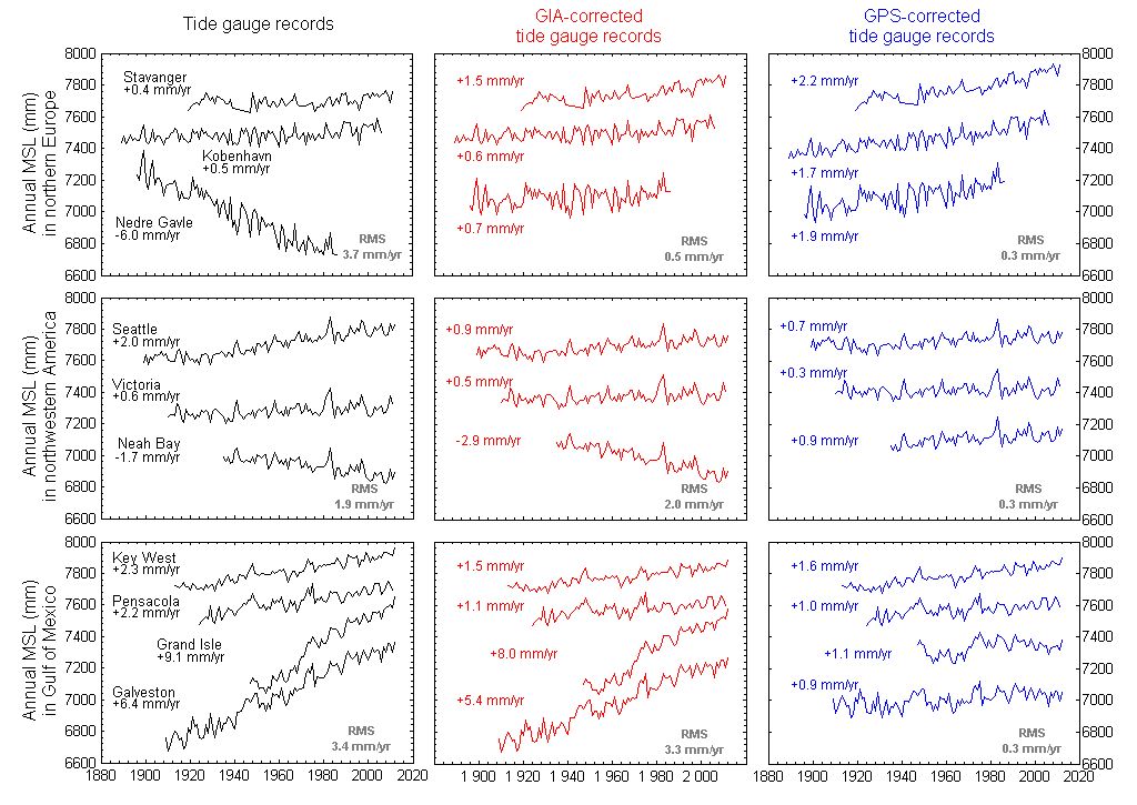
- The processing of GPS observations is particularly complex for the calculation of vertical movements of the land on which the tide gauges are placed (movements of the order of mm/year). The article published in 2007 by the members of the consortium of the ‘ULR’ GPS analysis centre describes the difficulties and the challenges raised by this issue. The figure opposite illustrates the challenges : shown on the left is a series of average sea levels measured with tide gauges ; in the middle the series are corrected with the predictions of the de postglacial rebound model ICE5G (VM2); on the right with the GPS velocities obtained by the ‘ULR’ centre in ITRF2008.
- To meet this challenge SONEL relies on the ULR analysis centre whose computation facilitiy is situated at the University of La Rochelle. The cluster acquired in 2008 reduced significantly the calculation time, from 1 year down to 2-3 weeks to process 10 years of GPS observations from a global network of some 200 stations. This has opened up new perspectives of experimentation and important avenues of research (new strategies, modeling, corrections). In particular, it enabled the ULR group to collaborate with 9 of the most prestigious groups in the spatial field in the first reprocessing campaign of the international service IGS.
– The latest ULR solution published in Global and Planetary Change is available in SONEL as time series of daily positions and velocities. Click on the link below to obtain more details and retrieve the results.
Survey on Continuous GNSS and Tide Gauge co-locations (GNSS@TG)
In order to get a better idea of the status and opportunities on continuous GPS positioning of tide gauges, a survey is carried out periodically within various geoscience communities. The survey aims to identify the existing permanent GPS stations which are close to tide gauges (up to approximately 10-15 km).
– The survey results can be viewed in conjunction with SONEL data holdings on the map (above). Purple symbols correspond to stations for which there are no observations in SONEL yet.
– By clicking on the table icon an on-line updated view of the CGPS@TG information that has been supplied to us is displayed. The table can be sorted by clicking on the column items, and a version of the view (table) can be downloaded in a format compatible with applications like excel (.csv).

- A ’.kmz’ file provides a Google Earth view of the CGPS@TG geographical distribution. The cgpstg.kmz file is consistent with the above mentionned table (updated weekly). Clicking on a station symbol provides ancillary information on the station, and further clicking on the station name provides access to the so-called GPS sitelog (if the GPS data are available). The CGPS@TG ’kmz’ view might be useful in conjunction with the ’.kmz’ files of satellite radar altimetry ground tracks provided by CLS, or with the ’.kmz’ file of tide gauge records provided by the PSMSL.
– In addition to the periodic surveys, information on CGPS@TG co-locations can also be supplied to us any time by filling in this form. Thank you in advance for your collaboration.
– The sitelog generation tool can help you generate a sitelog file for your station, suitable with IGS requirements.


