
WLADYSLAWOWO
Contributing agency

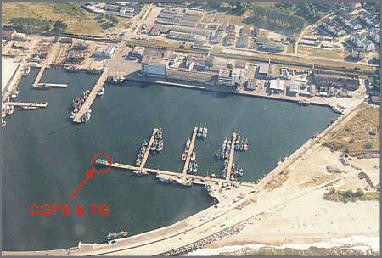
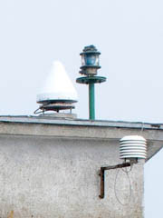
Station summaryWLAD

GNSS-IR


| IGS-type acronym : | WLAD00POL |
| Latitude : | 54.79681100 |
| Longitude : | 18.41870800 |
| Installed date : | 2003-04-16 |
| Decommissioned date : | |
| Country : | POLAND |
| City: | WLADYSLAWOWO |
| Station status : | active (green) |
| Distance to Tide Gauge (m) : | 2 |
| Domes Nr.: | 12222M001 |
| Station operator: | (ASG-EUPOS) - ASG-EUPOS |
| IGS-like station form : |
GPS position times seriesWLAD
Position
(Reference epoch: )
(Reference epoch: )
Offsets (mm)
| M | Material change or malfunction |
| E | Earthquake |
| RF | Reference Frame change |
| U | Unknown |
| NA | Not available |
| Position discontinuity | |
| Velocity discontinuity |
Data available at SONELWLAD
Quality plots on RINEX filesWLAD
 |
 |
Plots generated using software developed with the EPN team at ROB |
| Observations & tracking performance | Satellite tracking |
 (this operation may take 20 to 45s)
The satellite tracking graph has been calculated for all stations for the first day of each month. If you wish to have a graph for another date, choose the 'Calculate a specific date' option.
Co-located instrumentsWLAD
- Tide gauge : WLADYSLAWOWO (WLATG)
Photo albumWLAD

BibliographyWLAD
If you have a relevant reference to suggest, please send-us an e-mail : sonel@sonel.org-
 Kowalczy, 2019. Changes in mean sea level on the coast of Baltic Sea on tide gouge data from years 1811_2015. Acta Geodynamica et Geomaterialia.


-
Kowalczyk, Naumowicz et al., 2019. Modern vertical crustal movements of the southern Baltic coast from tide gauge, satellite altimetry and GNSS observations. Acta Geodynamica et Geomaterialia.
-
Lyszkowicz, Bernatowicz, 2019. Geocentric Baltic Sea level changes along the southern coastline. Advances in Space Research.
-
Lyszkowicz, Bernatowicz, 2018. Absolute sea level changes at the tide gauge station in Władysławowo using different time series software packages. Geodesy, Cartography, and Aerial Photography.
-
Pajak, Kowalczyk, 2019. A comparison of seasonal variations of sea level in the southern Baltic Sea from altimetry and tide gauge data. Advances in Space Research.


