
NANOOSE
Contributing agency

Station summaryNANO


| IGS-type acronym : | NANO00CAN |
| Latitude : | 49.29481069 |
| Longitude : | -124.08647883 |
| Installed date : | 1995-05-13 |
| Decommissioned date : | |
| Country : | CANADA |
| City: | NANOOSE BAY |
| Station status : | active (green) |
| Distance to Tide Gauge (m) : | 4625 |
| Domes Nr.: | 40138M001 |
| Station operator: | (GSC) - Geological Survey of Canada |
| IGS-like station form : |
GPS position times seriesNANO
(Reference epoch: )
| M | Material change or malfunction |
| E | Earthquake |
| RF | Reference Frame change |
| U | Unknown |
| NA | Not available |
| Position discontinuity | |
| Velocity discontinuity |
Data available at SONELNANO
Quality plots on RINEX filesNANO
 |
 |
Plots generated using software developed with the EPN team at ROB |
| Observations & tracking performance | Satellite tracking |
 (this operation may take 20 to 45s)
The satellite tracking graph has been calculated for all stations for the first day of each month. If you wish to have a graph for another date, choose the 'Calculate a specific date' option.
Co-located instrumentsNANO
- Tide gauge : NANOOSE BAY (NANOO)
Photo albumNANO

Log bookNANO
[IGSSTATION-7939] - 2020-04-24 (15/05/2020)
Communications have now been restored and all data files from the time of service failure at 2020-04-16T15:00 UT have been retrieved complete and sent to the appropriate directories.
[IGSSTATION-7934] - 2020-04-18 (15/05/2020)
Effective 2020-04-16T15:00 UT we lost connection to the site. We are working to resolve this issue as soon as possible. There should be no loss of data. A subsequent Advisory will be posted once file retrievals are restored.
[IGSSTATION-7898] - 2020-02-25 (18/03/2020)
The firmware of the PolaRx5 receivers at IGS station BAMF, NANO and UCLU have been upgraded to 5.3.2 today. The updated IGS log files have been submitted.
[IGSSTATION-7872] - 2020-02-10 (17/03/2020)
GPS TRACKER ID: NANO
DOMES No.: 40138M001
CDP No. n/a
MONUMENT No. 957000
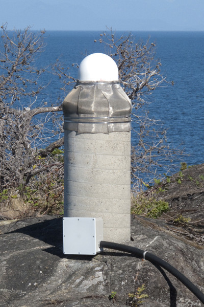
LOCATION: Winchelsea Island, Nanoose, B.C., Canada
Referencing IGSSTATION 7867, communications have now been restored as of 2020-02-06 and all missing data caught up and posted.
[IGSSTATION-7867] - 2020-02-06 (17/03/2020)
GPS TRACKER ID: NANO
DOMES No.: 40138M001
CDP No. n/a
MONUMENT No. 957000
LOCATION: Winchelsea Island, Nanoose, B.C., Canada
An issue has occurred at our site which has impacted the communications link. Site personnel are currently working on the problem. We do not know at this time when this issue will be resolved.
[IGSSTATION-7722] -2019-08-27 (20/09/2019)
The daily file for 2019-229 was posted in error. It was missing a 1 hr time period. A new and complete daily file has now been generated, and has been posted to the ftp directories.
[IGSSTATION-7368] -2018-07-21 (25/07/2018)
Please note that communications to the site are currently down, and we have been told that repairs to the network will be complete by Tuesday (July 24).
I do not anticipate any loss of data.
[IGSSTATION-7278] -2018-03-19 (20/03/2018)
Please note that due to a networking issue, we have lost communications to the site. This issue should be resolved in the next couple of days and there should be no data loss.
[IGSSTATION-7236] -2018-02-20 (26/02/2018)
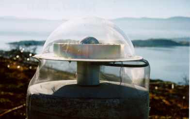
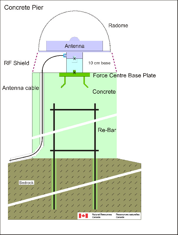
The Leica GRX1200GGPRO receiver and antenna/dome were replaced by a Septentrio PolarX5 receiver and Septentrio SEPCHOKE_B3E6 SPKE antenna/dome combination. The antenna height was changed from 0.100 m to 0.0771 m. The antenna cable length was changed from 100 m to 54 m. These changes were effective 2018-02-14T22:38:30 Z. There is a permanent data gap from 2018-02-14T17:38:30 Z to 2018-02-14T22:38:30 Z.
An updated site log will be submitted shortly to the CB and will also be available by AFTP from:
ftp://wcda.pgc.nrcan.gc.ca/pub/siteinfo
[IGSSTATION-7229] -2018-02-14 (16/02/2018)
Please be advised that on February 14, 2018, there will be a change to the receiver and antenna, and antenna height. There will be a short data gap, coincident with this work. Upon completion, an Advisory will be issued to detail the changes, and an updated site log will be submitted to the CB.


