Progress report on the survey
- (December,
2003) -
G. Wöppelmann, C. Bruyninx, P. Woodworth
Note : The dynamic tables below are continuously updated. Please, don't hesitate to complete the form given here or to sent an E-mail to Guy Wöppelmann (gwoppelm@univ-lr.fr) to help us to keep this survey up-to-date.
In order to get a better idea about the status and opportunities on continuous GPS positioning of tide gauges, a survey is carried out within various geoscience communities since October 1999. The survey aims at identifying the existing permanent GPS stations which are close to tide gauges (up to approximately 10 km). Three progress reports have been released so far :
The 2001 progress report was presented to the GLOSS group of experts during its 7th meeting held in Hawaii, April 2001. An action item was agreed on there : to update the list of GPS receivers at tide gauge sites at regular intervals. Actually the list is continuously updated. However, an announce is sent through mailing lists before a new progress report is released. Last report was presented at the "Vertical crustal motion and sea level change" Workshop held in Toulouse in 2002.
Considering the involvement of DORIS teams in the monitoring of vertical land motions, with the aim of removing the land motion signal from the tide gauge sea level records, the present survey is extended to DORIS ground stations that fulfill the vicinity criteria. The survey might further be extended to other advanced geodetic techniques.
The results of the survey are stored in a database whose contents can be browsed and searched through a web interface. Go to the following URLs to get a view of the survey tables :
The main views are ordered by station name. The 'Search' link presents a form that can be filled up with criteria. A subset of the data matching these criteria will then be displayed. The 'List all' link scrolls the view to the entire list of stations.
Few explanations on the table colums. Columns 2,3,4 are the name, longitude and latitude of the GPS (DORIS) station. The first column is an internal database index and the other ones are :
The codes represent an official commitment to a specific network. Therefore, they may give an idea of the quality, interest and data availability.
The following tables are simple text tables produced for the report in order to outline certain characteristics. (You just have to click on the links to access them).
General :
GLOSS related information :
Sorted by distance to the tide gauge :
Data availability, IGS and TIGA-PP :
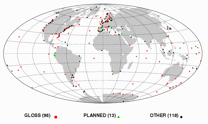
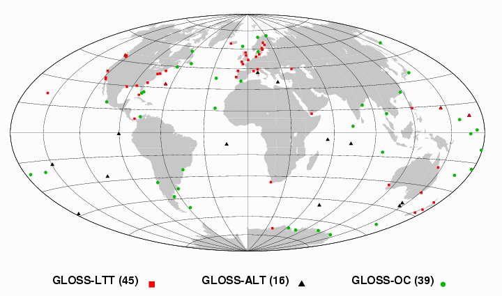
The amount of operational permanent GPS stations less than about 10 km away from a tide gauge has increased from 153 to 214 since the last progress report. There are still 13 planned stations meeting the vicinity criterion. Overall, the stations are distributed worldwide (see figure 1), though not evenly. There is a bias towards the Northern hemisphere. The geographical bias is variable but is always worse when looking at restricted set of stations belonging to a particular application or technical theme (GLOSS, Less than 1 km,... see figures 2 and 3 for instance).
Figure 1
95 are tide gauge / GPS sites committed to GLOSS,
Figure 2
It is quite interesting to have a look at the distance between the GPS antenna and the tide gauge. An extended survey has shown that 66 GPS stations are less than 1000 meters away from the tide gauge (30 out of 66 are GLOSS ones, see map below), 8 stations are between 1 and 3 km and 29 are between 3 and 10 km. Distance information is still missing for 99 stations. And yet this feature is critical for some applications like GLOSS-LTT : In no circumstances can it be assumed that even relatively close sites are not moving differentially at the mm/year level.
Therefore, frequent levellings (at least annually) are required over a long period of time (10-20 years). Experience shows that these regular levelling surveys are often neglected over time, in particular if the distance involved is more than a few hundred metres. Where the distance is more than 1 km, it is unlikely anyone will perform a levelling tie on a regular basis. Moreover, the levelling error can become a significant part of the total error budget. So, stations more than 1 km away cannot be considered 'nearly collocated' in the practical sense, though they may still be of interest for other applications (GLOSS-OC...). Nevertheless, some GPS stations are considered here even if they are more than 10 km away from the tide gauge. This is acceptable if there is evidence of local stability and if a rigorous and frequent surveying program is undertaken within CGPS@TG project.
Figure 3
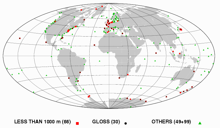
Figure 4 shows the stations for which GPS observations can be retrieved freely on Internet, in particular at the dedicated CGPS@TG data centre located at the University of La Rochelle (Anonymous FTP server address ftp.sonel.org). 43 out of 134 of these stations contribute to the IGS TIGA Pilot Project.
Figure 4
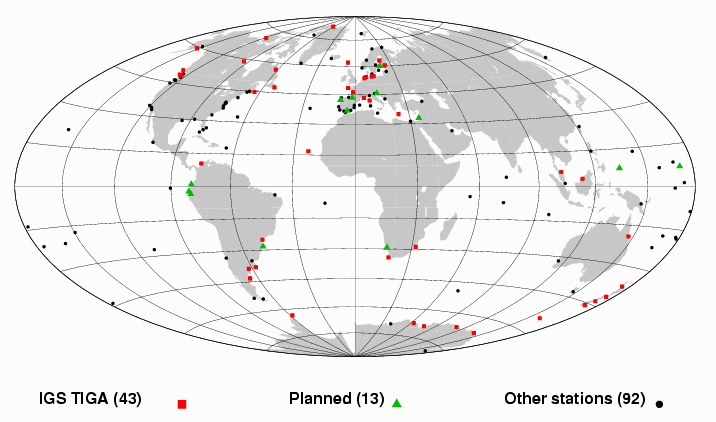
The next figure shows the amount of CGPS stations available each day at the University of La Rochelle (ULR) data centre. This data centre supports the IGS TIGA Pilot Project by retrieving, archiving and making available CGPS data files that may be worth for this project. Among them are the so-called "core stations" that should provide the best possible access to the reference frame. Availability of the 55 TIGA recommended IGS core stations is represented in red. The last curve in the graph represents the subset of core stations used by the ULR TIGA Analysis Centre.

The survey highlights that data of almost 40% of the stations is not available to the GLOSS or IGS scientific community yet (79 out of 214). Of course, all these stations may not be useful for scientific applications. A close inspection should therefore be undertaken. More information is also needed to actually take benefit of CGPS@TG site collocations, for instance :
IGS-PSMSL [1997] : Proceedings of the workshop on methods for monitoring sea level, March 17-18, 1997, Pasadena (California), 202 pp.
M. Bevis [1998] : "Continuous GPS positioning of tide gauges : some preliminary considerations". Report to the IGS. GLOSS Bulletin Nr. 6.
M. Bevis, W. Scherer and M. Merrifield [2000] : Technical issues and recommendations related to the installation of continuous GPS stations at tide gauges.
CGPS@TG Working Group : CGPS@TG Website - A technical forum on continuous GPS monitoring of tide gauges.
TIGA Website : GPS Tide Gauge Benchmark Monitoring - Pilot Project of the International GPS Service.
ESEAS Website : European Sea Level Service.
DORIS Stations Handbook on the Web at IGN France.