Progress report on the survey
- (February 17,
2005) -
by Guy Wöppelmann
and Tilo Schoene
Note : The dynamic tables below are continuously updated. Please, don't hesitate to complete the form given here or to sent an E-mail to Guy Wöppelmann (gwoppelm@univ-lr.fr) to help us to keep this survey up-to-date.
In order to get a better idea about the status and opportunities on continuous GPS positioning of tide gauges, a survey is carried out within various geoscience communities since October 1999. The survey aims at identifying the existing permanent GPS stations which are close to tide gauges (up to approximately 10 km). Four progress reports have been released so far :
The 2001 progress report was presented to the GLOSS group of experts during its 7th meeting held in Hawaii, April 2001. An action item was agreed on there : to update the list of GPS receivers at tide gauge sites at regular intervals. Actually the list and tables are continuously updated. However, a new formal report is released after a GLOSS GE meeting.
Considering the involvement of DORIS teams in the monitoring of vertical land motions, with the aim of removing the land motion signal from the tide gauge sea level records, the present survey is extended to DORIS ground stations that fulfill the vicinity criteria. The survey might further be extended to other advanced geodetic techniques.
The results of the survey are stored in a database whose contents can be browsed and searched through a web interface. Go to the following URLs to get a view of the survey tables :
The main views are ordered by station name. The 'Search' link presents a form that can be filled up with criteria. A subset of the data matching these criteria will then be displayed. The 'List all' link scrolls the view to the entire list of stations.
Few explanations on the table colums. Columns 2,3,4 are the name, longitude and latitude of the GPS (DORIS) station. The first column is an internal database index and the other ones are :
The codes represent an official commitment to a specific network. Therefore, they may give an idea of the quality, interest and data availability.
The following tables are simple text tables produced for the report in order to outline certain characteristics. (You just have to click on the links to access them).
General :
GLOSS related information :
Sorted by distance to the tide gauge :
Data availability and IGS pilot project TIGA :
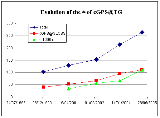
The amount of operational permanent GPS stations less than about 10 km away from a tide gauge has increased from 214 to 264 since the last progress report. Figure 1 illustrates this evolution since the survey was first undertaken in 1999.
Figure 1
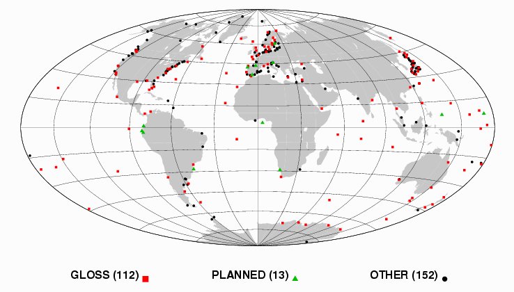
There are still 13 planned stations meeting the vicinity criterion. Overall, the stations are distributed worldwide (see figure 2), though not evenly. It is worth to note that 112 out of the 264 tide gauge / GPS sites are stations committed to GLOSS.
Figure 2
cGPS@TG stations distributed world wide
It is quite interesting to have a look at the distance between the GPS antenna and the tide gauge. The survey shows that 110 GPS stations are less than 1000 meters away from the tide gauge (44 out of 110 are GLOSS ones, see map below), 9 stations are between 1 and 3 km and 31 are between 3 and 10 km. Distance information is still missing for 100 stations. And yet this feature is critical for some applications like GLOSS-LTT : In no circumstances can it be assumed that even relatively close sites are not moving differentially at the mm/year level (IOC, 2000).
Therefore, frequent levellings (at least annually) are required over a long period of time (10-20 years). Experience shows that these regular levelling surveys are often neglected over time, in particular if the distance involved is more than a few hundred metres. Where the distance is more than 1 km, it is unlikely anyone will perform a levelling tie on a regular basis. Moreover, the levelling error can become a significant part of the total error budget. So, stations more than 1 km away cannot be considered 'nearly collocated' in the practical sense, though they may still be of interest for certain applications. Nevertheless, some GPS stations are considered here even if they are more than 10 km away from the tide gauge. This is acceptable if there is evidence of local stability and if a rigorous and frequent surveying program is undertaken within CGPS@TG project.
Figure 3
Continuously GPS stations operating less than 1000 meters
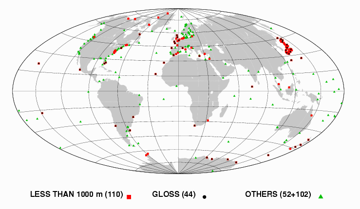
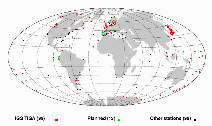
Figure 4 shows the stations for which the access to the GPS observations was identified. Data from about 75% of the cGPS@TG stations reported here are actually freely available on Internet, following the IGS philosophy of sharing the data for mutual benefits (precise orbits, clocks...). A few more may still be available for scientific purposes under certain conditions. Figure 4 outlines those stations that have committed to TIGA.
Figure 4
Permanent GPS stations for which access to the data was
identified
A dedicated data centre was set up in 2001 at the University of La Rochelle to gather, archive and make available as much cGPS data files as possible to support the scientific community interested by the cGPS@TG synergy. In particular, this data centre supports the IGS TIGA Pilot Project. Its anonymous FTP server address is: ftp.sonel.org.
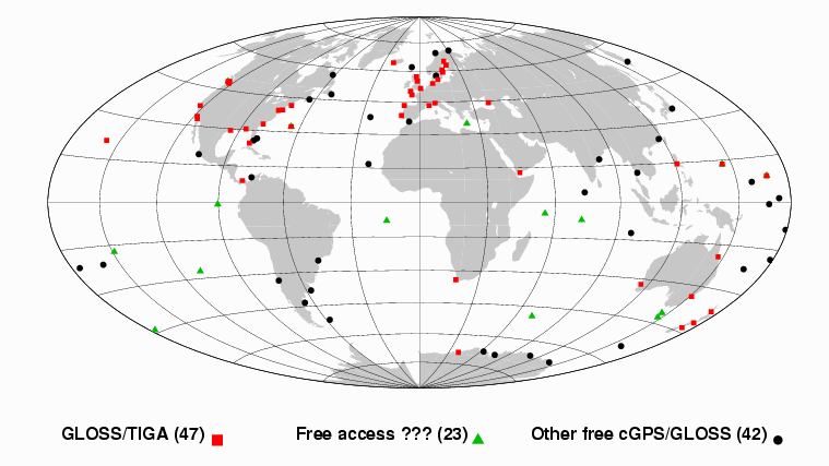
Today, 99 stations have committed to TIGA. Among them 47 are GLOSS out of the potential of 112 cGPS@GLOSS stations. The access to their data for scientific purposes is therefore ensured by this international commitment to IGS. Moreover, the survey has located free access to GPS data files of 42 additional cGPS@GLOSS stations.
Figure 5
cGPS@GLOSS stations for which data is freely accessible
The survey highlights that data of almost 25% of the stations is not available to the GLOSS or IGS scientific community yet (67 out of 264). Of course, all the stations may not be useful for scientific applications. But for sure GLOSS stations are useful for scientists ! Actions should therefore be undertaken : (i) to make the cGPS@GLOSS data files freely available as are the tide gauge data files, (ii) to ensure that this GPS data will be processed by as much groups as possible. Determining rates of vertical crustal motions in a well-defined global reference frame with an accuracy better than 1 mm/yr is a very challenging problem in Geodesy today. The IGS TIGA pilot project aim to address these issues, but this means an active participation and commitment to the project. In particular, the GPS sitelog and the TIGA Observing Station form should be kept up-to-date whenever a change occurs at the station. The local contacts are requested to ensure that the updated forms are properly delivered to all the members of the project through the TIGA mailing lists : tiga_tac@gfz-potsdam.de and tiga_all@gfz-potsdam.de
More information is also needed to actually take benefit of CGPS@TG site collocations, for instance :
IGS-PSMSL [1997] : Proceedings of the workshop on methods for monitoring sea level, March 17-18, 1997, Pasadena (California), 202 pp.
M. Bevis [1998] : "Continuous GPS positioning of tide gauges : some preliminary considerations". Report to the IGS. GLOSS Bulletin Nr. 6.
M. Bevis, W. Scherer and M. Merrifield [2000] : Technical issues and recommendations related to the installation of continuous GPS stations at tide gauges.
CGPS@TG Working Group : CGPS@TG Website - A technical forum on continuous GPS monitoring of tide gauges.
Harrison D.E. [2005] : Tide gauge measurements of sea level: requirements for climate monitoring and research. Report of the OOPC chair. 28 January 2005.
IOC [2000] : Manual on sea level measurement and interpretation. IOC Manuals and Guides n°14. Volume III: Reappraisals and Recommendations as of the year 2000.
TIGA Website : GPS Tide Gauge Benchmark Monitoring - Pilot Project of the International GPS Service.
ESEAS Website : European Sea Level Service.
DORIS Stations Handbook on the Web at IGN France.