

New GNSS@TG contribution from Estonia (12 stations from MAA-MET)
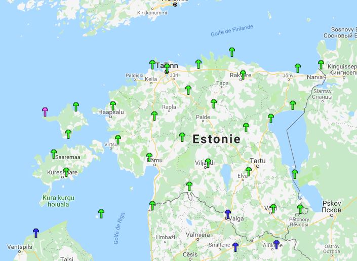
The Estonian Land Board (MAA-AMET Service) operates the ESTPOS network, which currently consists of 29 permanent GNSS stations homogeneously distributed across the country (click on the right map to enlarge, and see their location, in green). Four of these stations contribute to the EUREF permanent GNSS network, namely:
- - Kuressaare (KURE)
- - Suurupi (SUR4),
- - Toila (TOIL),
- - and Toravere (TOR2). Click on the 4 character GNSS identifier to access the EUREF webpage of a particular station, and see its details (pictures, local map, etc.).
Out of the 29 GNSS stations, 12 are co-located at (or nearby) tide gauges. By making their observations available to SONEL, the Estonian Land Board contributes to the scientific objectives of the global sea level observing programme (GLOSS) and to the IGS Working Group (TIGA) on GNSS tide gauge benchmark monitoring. These data contribute to assess the vertical stability of the land upon which the tide gauges are grounded. As SONEL users know, this information on vertical land motion is key to understanding sea level change and variability as observed by tide gauges, in particular to separate contributions from climate change (e.g., land ice melting, thermal expansion) and from solid Earth (e.g., subsidence due to groundwater extraction, sediment compaction, or post-glacial rebound).
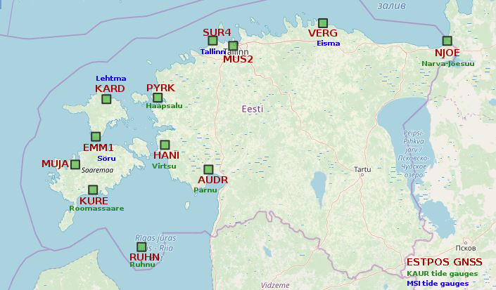

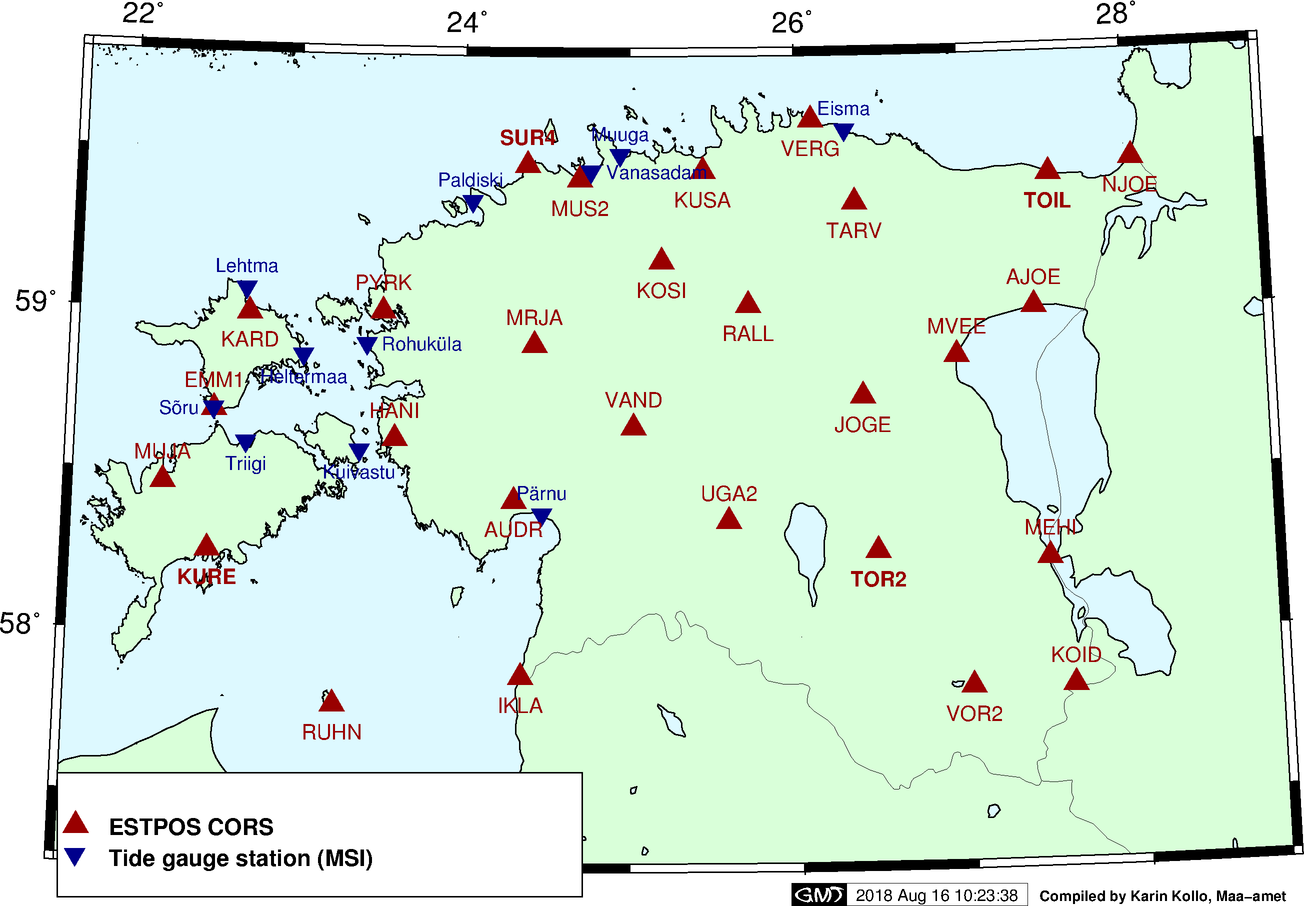
The 12 permanent GNSS stations are co-located with tide gauges from two networks / agencies, namely from the Estonian Environmental Agency (KAUR) and from the Maritime Institute (MSI) at Tallinn University of Technology. Click on the right thumbnail maps to enlarge, and get an overview of the location of the tide gauges within each network.
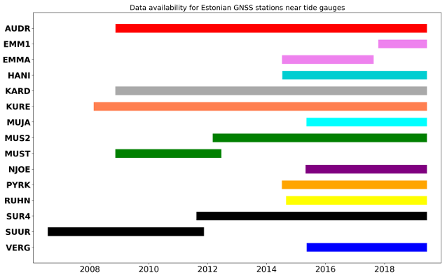
End of 2018, SONEL has contacted the Estonian Land Board (MAA-AMET Service), regarding the data availability of the 12 permanent GNSS stations installed near a tide gauge. And since January 2019, the daily observation in RINEX format are available on SONEL. The timeline below shows the record length for each station, and data availability for each of the 12 GNSS stations.
| GPS NAME | ACRONYM | LATITUDE | LONGITUDE | TIDE GAUGE | DISTANCE TIDE GAUGE-GNSS | INSTALLATION DATE | LENGTH |
|---|---|---|---|---|---|---|---|
| AUDRU | AUDR | 58.38472222 | 24.48083333 | PARNU | 10616 m | 2007-11-13 | 10 years |
| EMMASTE | EMM1 | 58.69073889 | 22.55356111 | SORU | 1831 m | 2017-12-06 | 1 years |
| EMMASTE | EMMA | 58.69073889 | 22.55356111 | SORU | 1830 m | 2014-09-01 | 3 years |
| HANILA | HANI | 58.62354722 | 23.63280833 | VIRTSU | 8918 m | 2014-09-05 | 4 years |
| KARDLA | KARD | 58.99437222 | 22.71956111 | LEHTMA | 8442 m | 2008-08-06 | 10 years |
| KURESSAARE | KURE | 58.21385833 | 22.50571389 | ROOMASSAARE | 4657 m | 2007-11-15 | 11 years |
| MUSTJALA | MUJA | 58.46315666 | 22.23255631 | SAAREMAA HARBOUR | 7843 m | 2015-09-04 | 4 years |
| MUSTAMAE2 | MUS2 | 59.42052778 | 24.69747222 | TALLINN | 5397 m | 2012-04-25 | 7 years |
| TALLINN | MUST | 59.42052778 | 24.69747222 | TALLINN | 5464 m | 2009-01-01 | 3 years |
| NARVA-JOESUU | NJOE | 59.46070000 | 28.04130556 | NARVA-JOESUU | 366 m | 2015-06-18 | 4 years |
| PURKSI | PYRK | 59.00657222 | 23.52128056 | HAAPSALU | 7181 m | 2014-08-25 | 4.5 years |
| RUHNU | RUHN | 57.78230833 | 23.26879167 | RUHNU | 598 m | 2014-10-18 | 4.5 years |
| SUURUPI | SUR4 | 59.42052778 | 24.69747222 | TALLINN | 22418 m | 2011-09-21 | 7.5 years |
| SUURUPI | SUUR | 59.42052778 | 24.69747222 | TALLINN | 22417 m | 1996-11-29 | 5 years |
| VERGI | VERG | 59.60148333 | 26.10078611 | EISMA | 12013 m | 2015-07-03 | 4 years |


