
LEVELING OF SETE
Benchmark positionning related to the tide gauge station
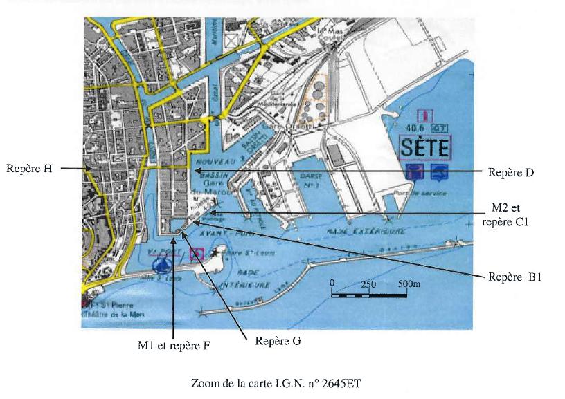

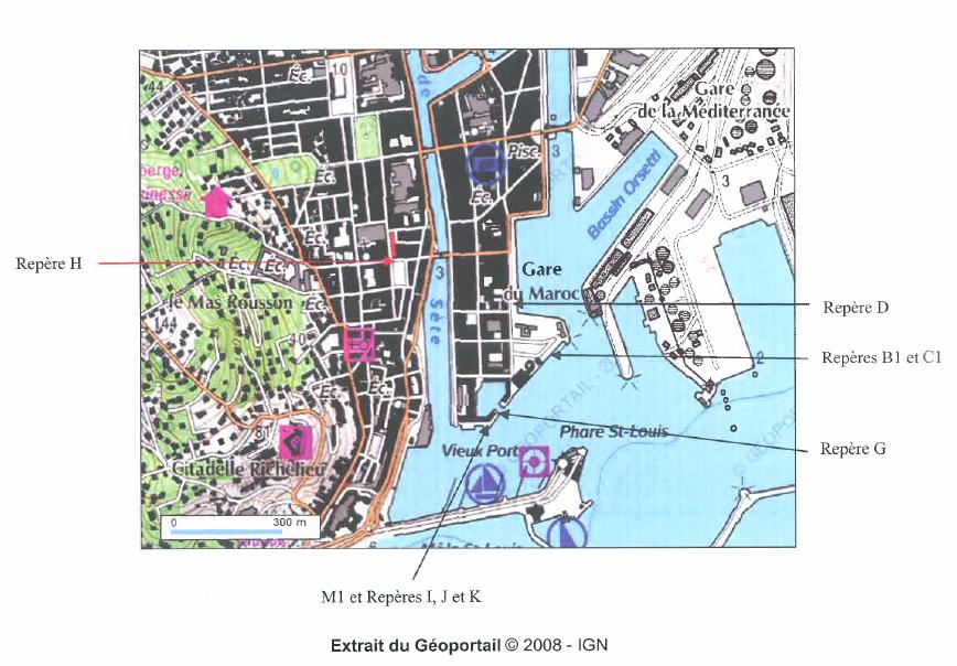
Benchmarks description table
Benchmarks vertical positionning diagram
Reference:
Leveling evolution
| Stand point | G | G | G | G | G | J | D | D | D | D | B1 | B1 | C1 | C1 | K | F | ||
|---|---|---|---|---|---|---|---|---|---|---|---|---|---|---|---|---|---|---|
| End point | K | J | N | D | H | H | H | J | SETE | L | D | H | D | H | D | H | ||
| Distance (m) | ---- | ---- | ---- | ---- | ---- | ---- | 355 | ---- | ---- | ---- | ---- | ---- | ---- | ---- | ---- | ---- | ||
| Height difference (m) | Campaign 9 | 2024-07-05 | --- | --- | --- | --- | --- | --- | --- | --- | --- | --- | --- | --- | --- | --- | --- | --- |
| Campaign 8 | 2019-05-28 | --- | --- | --- | --- | --- | --- | --- | --- | --- | --- | --- | --- | --- | --- | --- | --- | |
| Campaign 7 | 2018-11-06 | --- | --- | --- | --- | --- | --- | --- | --- | --- | --- | --- | --- | --- | --- | --- | --- | |
| Campaign 6 | 2015-03-26 | --- | --- | --- | --- | --- | --- | --- | --- | --- | --- | --- | --- | --- | --- | --- | --- | |
| Campaign 5 | 2010-06-30 | 1.4093 ± 0.001 | 3.1202 ± 0.001 | -0.1317 ± 0.001 | --- | --- | 1.6858 ± 0.001 | --- | --- | --- | --- | --- | --- | --- | --- | --- | --- | |
| Campaign 4 | 2009-04-09 | --- | 3.1203 ± 0.001 | --- | --- | --- | 1.6858 ± 0.001 | --- | --- | --- | --- | --- | --- | --- | --- | --- | --- | |
| Campaign 3 | 2008-06-18 | --- | --- | --- | --- | --- | --- | 3.8658 ± 0.001 | --- | --- | --- | --- | --- | --- | --- | --- | --- | |
| Campaign 2 | 2007-10-20 | --- | --- | --- | 0.9400 ± 0.001 | --- | --- | --- | 2.1800 ± 0.001 | 2.1820 ± 0.001 | 3.2160 ± 0.001 | 1.0810 ± 0.001 | --- | 0.9690 ± 0.001 | --- | 0.3640 ± 0.001 | --- | |
| Campaign 1 | 2004-09-03 | --- | --- | --- | --- | 4.8090 ± 0.001 | --- | 3.8670 ± 0.001 | --- | --- | --- | --- | 4.9500 ± 0.001 | --- | 4.8380 ± 0.001 | --- | 4.4610 ± 0.001 | |
| Height difference evolution graph |  |  |  |  |  |  |  |  |  |  |  |  |  |  |  |  | ||
Download leveling data
TIDE GAUGE LOCAL LEVELING NETWORK DATA OF STATION SETE
-----------------------------------------------------------------------------------------------------
Benchmark Lat. Long. Height Year of determination St.dev Distance_to_TG
10chr (°) 14chr (°) 14chr (m) 10chr 22chr (m)10chr (m) 10chr
-----------------------------------------------------------------------------------------------------
H 43.401694 3.696167 12.922 2024 0.00000 510
B1 ---- ---- 7.982 2024 0.00100 ----
C1 ---- ---- 8.093 2024 0.00100 ----
D 43.399889 3.699778 9.058 2024 0.00100 260
F ---- ---- 8.461 2004 0.00100 ----
G ---- ---- 8.119 2024 0.00100 ----
SETE ---- ---- 11.237 2007 0.00100 ----
J ---- ---- 11.236 2010 0.00100 ----
K ---- ---- 8.693 2018 0.00300 ----
L ---- ---- 12.271 2007 0.00100 ----
N ---- ---- 7.964 2018 0.00200 ----
M.C.K3-67 ---- ---- ---- ---- ---- ----
M.C.J3K3-4 ---- ---- ---- ---- ---- ----
M.C.J3K3-4 ---- ---- ---- ---- ---- ----
O ---- ---- 8.525 2024 0.00100 ----
P ---- ---- 8.429 2024 0.00100 ----
Q ---- ---- 8.411 2024 0.00100 ----
R ---- ---- 9.905 2024 0.00200 ----
SET1 ---- ---- 15.978 2024 0.00100 ----


