
RABAT
Station summaryRABT


| IGS-type acronym : | RABT |
| Latitude : | 33.99810028 |
| Longitude : | -6.85429001 |
| Installed date : | 2000-05-07 |
| Decommissioned date : | |
| Country : | MOROCCO |
| City: | RABAT |
| Station status : | active (green) |
| Domes Nr.: | 35001M002 |
| Station operator: | (JPL) - Jet Propulsion Laboratory |
| IGS-like station form : |
GPS position times seriesRABT
(Reference epoch: )
| M | Material change or malfunction |
| E | Earthquake |
| RF | Reference Frame change |
| U | Unknown |
| NA | Not available |
| Position discontinuity | |
| Velocity discontinuity |
Data available at SONELRABT
Quality plots on RINEX filesRABT
 |
 |
Plots generated using software developed with the EPN team at ROB |
| Observations & tracking performance | Satellite tracking |
 (this operation may take 20 to 45s)
The satellite tracking graph has been calculated for all stations for the first day of each month. If you wish to have a graph for another date, choose the 'Calculate a specific date' option.
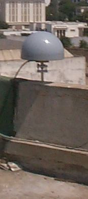
Photo albumRABT
Log bookRABT
[IGSSTATION-7694] - 2019-07-03 (29/07/2019)
A new receiver was installed at RABT. Publication has resumed today (2019-07-02), and backlogged data will be provided starting from 2019-06-19. An updated site log has been submitted to the IGSCB.
3.3 Satellite System : GPS
Serial Number : UC2200436008
Firmware Version : CQ00
Elevation Cutoff Setting : 4 deg
Date Installed : 2009-02-06T00:00Z
Date Removed : 2019-06-18T00:00Z
Temperature Stabiliz. : none
Additional Information :
3.4 Receiver Type : JAVAD TRE_3 DELTA
Satellite System : GPS GLO GAL BDS
Serial Number : 02334
Firmware Version : 3.7.6
Elevation Cutoff Setting : 0 deg
Date Installed : 2019-06-18T00:00Z
Date Removed : CCYY-MM-DDThh:mmZ
Temperature Stabiliz. : none
Additional Information :


