
LEVELING OF CROZET
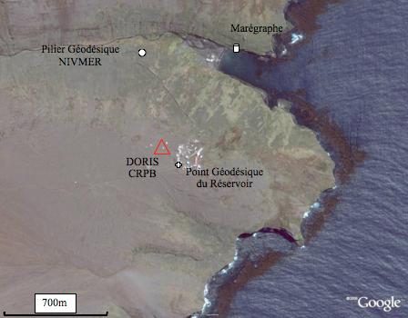
Benchmark positionning related to the tide gauge station
Benchmarks description table
Benchmarks vertical positionning diagram
Reference:
Leveling evolution
| Stand point | ||
|---|---|---|
| End point | ||
| Distance (m) | ||
| Height difference (m) | Campaign 3 | 2023-03-28 |
| Campaign 2 | 2022-03-26 | |
| Campaign 1 | 2007-04-05 | |
| Height difference evolution graph | ||
Download leveling data
TIDE GAUGE LOCAL LEVELING NETWORK DATA OF STATION CROZET
-----------------------------------------------------------------------------------------------------
Benchmark Lat. Long. Height Year of determination St.dev Distance_to_TG
10chr (°) 14chr (°) 14chr (m) 10chr 22chr (m)10chr (m) 10chr
-----------------------------------------------------------------------------------------------------
NIVMER -46.426182 51.854402 51.711 2022 0.00100 640
réservoir -46.432630 51.856955 ---- ---- ---- 150
CRPB -46.431831 51.855584 ---- ---- ---- 20
CROB -46.431831 51.855584 149.596 2022 0.00100 20
CRQB ---- ---- ---- ---- ---- ----
98404C2 -46.431086 51.859044 123.239 2022 0.00200 300
98404C3 46.431023 51.858618 124.780 2022 0.00200 9196280
98404C4 46.432685 51.857522 138.355 2022 0.00200 9196410
CZTG -46.431831 51.855584 149.705 2022 0.00200 20
A -46.425618 51.862810 0.000 2023 0.00000 910
B -46.425618 51.862810 0.631 2022 0.00100 910
C -46.425618 51.862810 0.614 2022 0.00100 910
D -46.425618 51.862810 -1.322 2022 0.00100 910
20 -46.427134 51.862073 -0.602 2023 0.00100 740
3000 -46.426012 51.860776 0.718 2023 0.00200 780
Co-located instruments
- Tide Gauge : CROZET (CROZE)
- GPS : CROZET (CZTG)
- Doris : CROZET (CRRC)
- GPS : Crozet Reflectometry (CZTR)


