
LEVELING OF ILE ROYALE
Benchmark positionning related to the tide gauge station
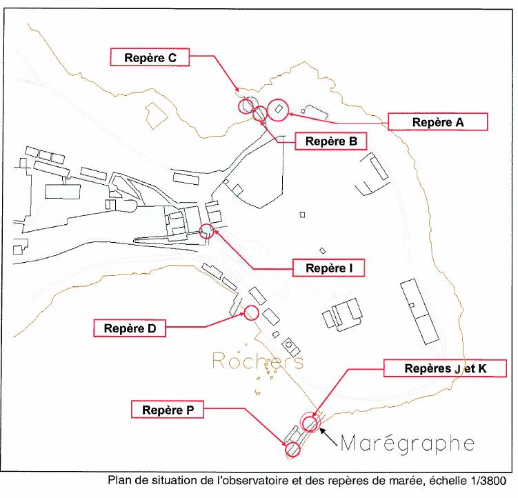

Benchmarks description table
Benchmarks vertical positionning diagram
Reference:
Leveling evolution
| Stand point | A | A | A | A | A | A | A | A | A | A | A | A | A | A | C | D | D | B | K | P | ||
|---|---|---|---|---|---|---|---|---|---|---|---|---|---|---|---|---|---|---|---|---|---|---|
| End point | B | D | I | J | K | P | a | b | c | d | e | f | IGN | IRYL | B | J | I | A | P | J | ||
| Distance (m) | ---- | ---- | ---- | ---- | ---- | ---- | ---- | ---- | ---- | ---- | ---- | ---- | ---- | ---- | ---- | ---- | ---- | ---- | ---- | ---- | ||
| Height difference (m) | Campaign 5 | 2024-02-16 | --- | --- | --- | --- | --- | --- | --- | --- | --- | --- | --- | --- | --- | --- | --- | --- | --- | --- | --- | --- |
| Campaign 4 | 2021-01-13 | --- | --- | --- | --- | --- | --- | --- | --- | --- | --- | --- | --- | --- | --- | --- | --- | --- | --- | --- | --- | |
| Campaign 3 | 2018-12-13 | --- | --- | --- | --- | --- | --- | --- | --- | --- | --- | --- | --- | --- | --- | --- | --- | --- | --- | --- | --- | |
| Campaign 2 | 2013-09-30 | -2.1640 ± 0.0001 | -2.2500 ± 0.0004 | 9.0700 ± 0.0003 | -1.4910 ± 0.0004 | -1.9800 ± 0.0005 | -1.7300 ± 0.0005 | 38.4780 ± 0.0005 | 38.4340 ± 0.0006 | 38.4240 ± 0.0006 | 38.4200 ± 0.0006 | 38.4320 ± 0.0005 | 39.0160 ± 0.0006 | -1.2680 ± 0.0004 | 1.3860 ± 0.0004 | --- | --- | --- | --- | --- | --- | |
| Campaign 1 | 2006-11-04 | --- | --- | 9.0680 ± 0.001 | --- | --- | --- | --- | --- | --- | --- | --- | --- | --- | --- | 1.2210 ± 0.001 | 0.7600 ± 0.001 | 11.3160 ± 0.001 | 2.1640 ± 0.001 | 0.2520 ± 0.001 | 0.2370 ± 0.001 | |
| Height difference evolution graph |  |  |  |  |  |  |  |  |  |  |  |  |  |  |  |  |  |  |  |  | ||
Download leveling data
TIDE GAUGE LOCAL LEVELING NETWORK DATA OF STATION Ile Royale
-----------------------------------------------------------------------------------------------------
Benchmark Lat. Long. Height Year of determination St.dev Distance_to_TG
10chr (°) 14chr (°) 14chr (m) 10chr 22chr (m)10chr (m) 10chr
-----------------------------------------------------------------------------------------------------
A ---- ---- 11.800 2024 0.00000 ----
B ---- ---- 9.636 2024 0.00100 ----
C ---- ---- 8.415 2006 0.00200 ----
D ---- ---- 9.550 2024 0.00100 ----
I ---- ---- 20.872 2024 0.00100 ----
J ---- ---- 10.308 2024 0.00100 ----
K ---- ---- 9.818 2018 0.00100 ----
P ---- ---- 10.070 2024 0.00100 ----
a ---- ---- 50.278 2013 0.00100 ----
b ---- ---- 50.234 2013 0.00100 ----
c ---- ---- 50.224 2013 0.00100 ----
d ---- ---- 50.220 2013 0.00100 ----
e ---- ---- 50.232 2013 0.00100 ----
f ---- ---- 50.816 2013 0.00100 ----
IGN ---- ---- 10.532 2013 0.00100 ----
IRYL ---- ---- 13.186 2018 0.00100 ----
N ---- ---- 10.532 2024 0.00100 ----
O ---- ---- 9.831 2024 0.00100 ----
IROY ---- ---- 13.241 2024 0.00100 ----
F ---- ---- 10.350 2018 0.00100 ----
Co-located instruments
- Tide Gauge : ILE ROYALE (ROYAL)
- Tide Gauge : ILE ROYALE - ANSE LEGOFF (LEGOF)
- GPS : Ile Royale (IRYL)
- GPS : Ile Royale (IROY)


