
LEVELING OF KEY BISCAYNE, MIAMI
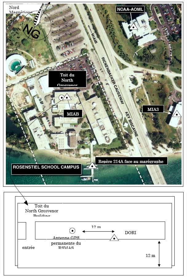
Benchmark positionning related to the tide gauge station
Benchmarks description table
Benchmarks vertical positionning diagram
Reference:
Leveling evolution
| Stand point | 3214-B | 3214-B | 3214-B | 3214-B | 3214-B | 3214-B | 3214-B | 3214-B | 3214-B | 3214-B | 3214-B | 3214-B | 3214-B | MIAB/mark | MIAB/mark | MIAB/mark | MIAB/mark | 3214 A | 3214 A | MIA3 | ||
|---|---|---|---|---|---|---|---|---|---|---|---|---|---|---|---|---|---|---|---|---|---|---|
| End point | 872-3214-G | 872 3214 D | 3214-H | 3214-J | 3214-K | 3214-M | 3214-P | 3214-R | 3214-S | T313 | BRUCE-2 | N300 | 3214-MWWM-SRP | MIAB/mark | 3214 A | MIA3 | AOML | MIA3 | AOML | AOML | ||
| Distance (m) | ---- | ---- | ---- | ---- | ---- | ---- | ---- | ---- | ---- | ---- | ---- | ---- | ---- | 0 | 115 | 295 | 230 | 180 | 213 | 291 | ||
| Height difference (m) | Campaign 2 | 2020-01-01 | -0.2620 ± 6.0E-6 | 0.1814 ± 6.0E-6 | 0.9024 ± 6.0E-6 | 0.3550 ± 6.0E-6 | 0.1318 ± 6.0E-6 | 0.1929 ± 6.0E-6 | 1.2626 ± 6.0E-6 | 0.2702 ± 6.0E-6 | -0.2807 ± 6.0E-6 | -0.9202 ± 6.0E-6 | -0.5735 ± 6.0E-6 | 3.1574 ± 6.0E-6 | 1.9537 ± 6.0E-6 | --- | --- | --- | --- | --- | --- | --- |
| Campaign 1 | 2005-02-08 | --- | --- | --- | --- | --- | --- | --- | --- | --- | --- | --- | --- | --- | -1.3650 ± 0.001 | -12.3940 ± 0.01 | -2.6790 ± 0.01 | 13.5740 ± 0.01 | 9.7150 ± 0.01 | 25.9680 ± 0.01 | 16.2530 ± 0.01 | |
| Height difference evolution graph |  |  |  |  |  |  |  |  |  |  |  |  |  |  |  |  |  |  |  |  | ||
Download leveling data
TIDE GAUGE LOCAL LEVELING NETWORK DATA OF STATION Miami
-----------------------------------------------------------------------------------------------------
Benchmark Lat. Long. Height Year of determination St.dev Distance_to_TG
10chr (°) 14chr (°) 14chr (m) 10chr 22chr (m)10chr (m) 10chr
-----------------------------------------------------------------------------------------------------
MIAB_ARP 25.732783 -80.163106 ---- ---- ---- 190
MIAB/mark 25.732783 -80.163106 19.999 2005 0.01000 190
3214 A 25.732783 -80.161964 7.605 2005 0.00000 150
MIA3 25.732810 -80.160170 17.320 2005 0.01500 240
AOML 25.734691 -80.162198 33.573 2005 0.01800 360
872-3214-G ---- ---- 7.238 2020 0.00100 ----
872 3214 D ---- ---- 7.681 2020 0.00100 ----
3214-B ---- ---- 7.500 2020 0.00000 ----
3214-H ---- ---- 8.402 2020 0.00100 ----
3214-J ---- ---- 7.855 2020 0.00100 ----
3214-K ---- ---- 7.632 2020 0.00100 ----
3214-M ---- ---- 7.693 2020 0.00100 ----
3214-P ---- ---- 8.763 2020 0.00100 ----
3214-R ---- ---- 7.770 2020 0.00100 ----
3214-S ---- ---- 7.219 2020 0.00100 ----
T313 ---- ---- 6.580 2020 0.00100 ----
BRUCE-2 ---- ---- 6.926 2020 0.00100 ----
N300 ---- ---- 10.657 2020 0.00100 ----
3214-MWWM- ---- ---- 9.454 2020 0.00100 ----
Co-located instruments
- GPS : Miami (AOML)
- Doris : MIAMI (MIAB)
- Tide Gauge : VIRGINIA KEY (MIAMI)
- Tide Gauge : MIAMI BEACH (MIAMB)
- GPS : UM1 (SA20)
- GPS : Miami 3 (MIA3)
- GPS : Virginia Key (N300)


