
LEVELING OF PONTA DELGADA
Benchmark positionning related to the tide gauge station
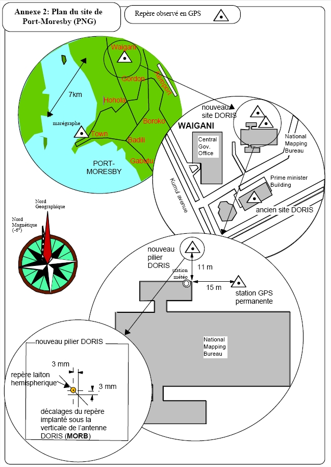
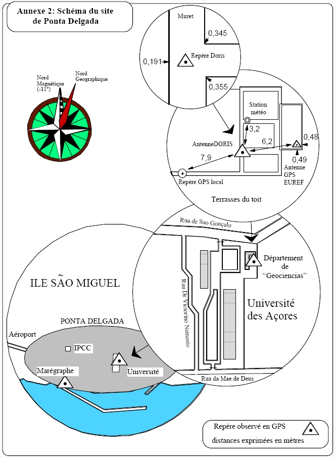
Benchmarks description table
Benchmarks vertical positionning diagram
Reference:
Leveling evolution
| Stand point | PDLB | PDLB | PDLB | PDLB | PDLB | PDLB | PDMB | PDMB | PDMB | PDMB | PDMB | Doris/mark | Doris/mark | Doris/mark | Doris/mark | Doris/mark | VLBI | VLBI | VLBI | VLBI | SBRA | SBRA | SBRA | MARE | MARE | MARE | PDD1 | PDD2 | ||
|---|---|---|---|---|---|---|---|---|---|---|---|---|---|---|---|---|---|---|---|---|---|---|---|---|---|---|---|---|---|---|
| End point | PDMB | Doris/mark | VLBI | SBRA | MARE | PDEL | Doris/mark | VLBI | SBRA | MARE | PDEL | VLBI | SBRA | MARE | PDEL | PDLB | SBRA | MARE | PDEL | PDLB | MARE | PDEL | PDLB | PDEL | SBRA | PDLB | PDEL | PDEL | ||
| Distance (m) | 0 | 0 | 463 | 1580 | 1516 | 6 | 0 | 463 | 1580 | 1516 | 6 | 463 | 1580 | 1516 | 6 | 0 | 1877 | 1792 | 457 | 463 | 121 | 1584 | 1580 | 1520 | 121 | 1516 | ---- | ---- | ||
| Height difference (m) | Campaign 2 | 2001-08-21 | 0.0070 ± 0.01 | -2.4290 ± 0.01 | -51.6190 ± 0.01 | -35.1200 ± 0.01 | -51.4350 ± 0.01 | 0.4780 ± 0.01 | -2.4360 ± 0.01 | -51.6260 ± 0.01 | -35.1270 ± 0.01 | -51.4420 ± 0.01 | 0.4710 ± 0.01 | -49.1900 ± 0.01 | -32.6910 ± 0.01 | -49.0060 ± 0.01 | 2.9070 ± 0.01 | --- | 16.4990 ± 0.01 | 0.1840 ± 0.01 | 52.0970 ± 0.01 | --- | -16.3150 ± 0.01 | 35.5980 ± 0.01 | --- | -51.9130 ± 0.01 | --- | --- | 0.8520 ± 0.001 | 0.8470 ± 0.001 |
| Campaign 1 | 1998-11-02 | --- | --- | --- | --- | --- | --- | --- | --- | --- | --- | --- | -49.1900 ± 0.01 | -32.6910 ± 0.01 | -49.0040 ± 0.01 | --- | 2.4280 ± 0.01 | 16.4990 ± 0.01 | 0.1860 ± 0.01 | --- | 51.6180 ± 0.01 | --- | --- | 35.1190 ± 0.01 | --- | 16.3130 ± 0.01 | 51.4320 ± 0.01 | --- | --- | |
| Height difference evolution graph |  |  |  |  |  |  |  |  |  |  |  |  |  |  |  |  |  |  |  |  |  |  |  |  |  |  |  |  | ||
Download leveling data
TIDE GAUGE LOCAL LEVELING NETWORK DATA OF STATION PONTA DELGADA
-----------------------------------------------------------------------------------------------------
Benchmark Lat. Long. Height Year of determination St.dev Distance_to_TG
10chr (°) 14chr (°) 14chr (m) 10chr 22chr (m)10chr (m) 10chr
-----------------------------------------------------------------------------------------------------
PDLB 37.747736 -25.662833 60.299 2001 0.01000 10
PDMB 37.747736 -25.662833 60.306 2001 0.01500 10
Doris/mark37.747736 -25.662833 57.870 2001 0.01800 10
VLBI 37.747736 -25.657584 8.680 2001 0.02000 460
SBRA 37.735899 -25.672788 25.179 2001 0.02300 1580
MARE 37.735899 -25.671418 8.864 2001 0.00000 1510
PDEL 37.747748 -25.662765 60.777 2001 0.02500 10
PDD1 ---- ---- 59.925 2001 0.02500 ----
PDD2 ---- ---- 59.930 2001 0.02500 ----
MN A ---- ---- 8.857 2001 0.00000 ----
MN C ---- ---- 8.785 2001 0.00000 ----
NP ---- ---- 8.887 2001 0.00000 ----
Co-located instruments
- GPS : PONTA DELGADA (PDEL)
- Tide Gauge : PONTA DELGADA (PDELG)
- Doris : PONTA DELGADA (PDOC)


