
LEVELING OF ST. JOHN'S
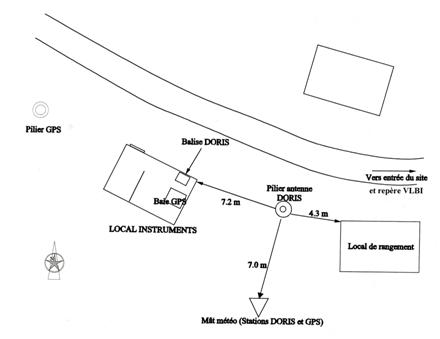
Benchmark positionning related to the tide gauge station
Benchmarks description table
Benchmarks vertical positionning diagram
Reference:
Leveling evolution
| Stand point | STJO | STJO | STJO | 90F9000 | 90F9000 | 90F9002 | 9803005 | 9803005 | DORIS | ||
|---|---|---|---|---|---|---|---|---|---|---|---|
| End point | DORIS | 9803005 | STJB | 90F9002 | 9803005 | 9803005 | DORIS | STJB | STJB | ||
| Distance (m) | 26 | 3615 | 26 | ---- | ---- | ---- | 3611 | 3611 | 0 | ||
| Height difference (m) | Campaign 1 | 1999-09-28 | -0.3940 ± 0.01 | -140.8150 ± 0.01 | 0.1250 ± 0.01 | -0.0440 ± 0.001 | -0.2320 ± 0.001 | -0.1880 ± 0.001 | 140.4210 ± 0.01 | 140.9400 ± 0.01 | 0.5200 ± 0.001 |
| Height difference evolution graph |  |  |  |  |  |  |  |  |  | ||
Download leveling data
TIDE GAUGE LOCAL LEVELING NETWORK DATA OF STATION ST. JOHN'S
-----------------------------------------------------------------------------------------------------
Benchmark Lat. Long. Height Year of determination St.dev Distance_to_TG
10chr (°) 14chr (°) 14chr (m) 10chr 22chr (m)10chr (m) 10chr
-----------------------------------------------------------------------------------------------------
STJO 47.595239 -52.677748 150.583 1999 0.01100 0
9803005 47.567242 -52.702171 9.768 1999 0.00200 3610
DORIS 47.595324 -52.678067 150.189 1999 0.01500 30
STJB 47.595324 -52.678067 150.709 1999 0.01500 30
90F9000 ---- ---- 10.000 1999 0.00000 ----
90F9002 ---- ---- 9.956 1999 0.00100 ----
Co-located instruments
- GPS : ST. JOHN'S (STJO)
- Tide Gauge : SAINT JOHN'S (SJOHN)
- GPS : STJ3 (STJ3)
- Doris : SAINT JOHN'S (STKC)


