LEVELING OF LAUTOKA
Benchmark positionning related to the tide gauge station

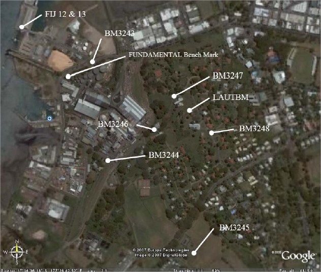
Benchmarks description table
Benchmarks vertical positionning diagram
Reference:
Leveling evolution
| Stand point | BM3243 | BM3243 | BM3243 | BM3243 | BM3243 | BM3243 | BM3243 | BM3243 | LAUTBM | ||
|---|---|---|---|---|---|---|---|---|---|---|---|
| End point | BM3244 | BM3245 | BM3246 | BM3247 | BM3248 | LAUTBM | FIJ13 | FIJ12 | LAUT | ||
| Distance (m) | ---- | ---- | ---- | ---- | ---- | ---- | ---- | ---- | ---- | ||
| Height difference (m) | Campaign 12 | 2008-06-15 | 1.0405 ± 0.001 | 13.5094 ± 0.001 | 4.6949 ± 0.001 | 17.8301 ± 0.001 | 32.1075 ± 0.001 | 28.2114 ± 0.001 | 1.3131 ± 0.001 | 0.9387 ± 0.001 | 0.9552 ± 0.001 |
| Campaign 11 | 2007-06-15 | 1.0394 ± 0.001 | 13.5080 ± 0.001 | 4.6935 ± 0.001 | 17.8287 ± 0.001 | 32.1048 ± 0.001 | 28.2099 ± 0.001 | 1.3128 ± 0.001 | 0.9379 ± 0.001 | 0.9552 ± 0.001 | |
| Campaign 10 | 2005-09-15 | 1.0389 ± 0.001 | 13.5081 ± 0.001 | 4.6932 ± 0.001 | 17.8284 ± 0.001 | 32.1049 ± 0.001 | 28.2094 ± 0.001 | 1.3110 ± 0.001 | 0.9370 ± 0.001 | 0.9552 ± 0.001 | |
| Campaign 9 | 2005-06-15 | 1.0394 ± 0.001 | 13.5077 ± 0.001 | 4.6934 ± 0.001 | 17.8286 ± 0.001 | 32.1047 ± 0.001 | 28.2090 ± 0.001 | 1.3111 ± 0.001 | 0.9372 ± 0.001 | 0.9552 ± 0.001 | |
| Campaign 8 | 2003-06-15 | 1.0350 ± 0.001 | 13.5042 ± 0.001 | 4.6894 ± 0.001 | 17.8248 ± 0.001 | 32.1009 ± 0.001 | 28.2053 ± 0.001 | 1.3083 ± 0.001 | 0.9339 ± 0.001 | 0.9552 ± 0.001 | |
| Campaign 7 | 2002-06-15 | 1.0347 ± 0.001 | 13.5028 ± 0.001 | 4.6885 ± 0.001 | 17.8241 ± 0.001 | 32.0998 ± 0.001 | 28.2052 ± 0.001 | 1.3063 ± 0.001 | 0.9318 ± 0.001 | 0.9552 ± 0.001 | |
| Campaign 6 | 2000-06-15 | 1.0345 ± 0.001 | 13.5029 ± 0.001 | --- | --- | --- | --- | 1.3067 ± 0.001 | 0.9326 ± 0.001 | --- | |
| Campaign 5 | 1998-06-15 | 1.0327 ± 0.001 | 13.4958 ± 0.001 | --- | --- | --- | --- | 1.3057 ± 0.001 | 0.9321 ± 0.001 | --- | |
| Campaign 4 | 1997-06-15 | 1.0322 ± 0.001 | 13.5008 ± 0.001 | --- | --- | --- | --- | 1.3056 ± 0.001 | 0.9323 ± 0.001 | --- | |
| Campaign 3 | 1995-06-15 | 1.0321 ± 0.001 | 13.5008 ± 0.001 | --- | --- | --- | --- | 1.3060 ± 0.001 | 0.9321 ± 0.001 | --- | |
| Campaign 2 | 1994-06-15 | 1.0312 ± 0.001 | 13.4985 ± 0.001 | --- | --- | --- | --- | 1.3051 ± 0.001 | 0.9312 ± 0.001 | --- | |
| Campaign 1 | 1992-06-15 | 1.0316 ± 0.001 | 13.4995 ± 0.001 | --- | --- | --- | --- | 1.3041 ± 0.001 | 0.9306 ± 0.001 | --- | |
| Height difference evolution graph |  |  |  |  |  |  |  |  |  | ||
Download leveling data
TIDE GAUGE LOCAL LEVELING NETWORK DATA OF STATION LAUTOKA
-----------------------------------------------------------------------------------------------------
Benchmark Lat. Long. Height Year of determination St.dev Distance_to_TG
10chr (°) 14chr (°) 14chr (m) 10chr 22chr (m)10chr (m) 10chr
-----------------------------------------------------------------------------------------------------
BM3243 ---- ---- 8.800 2008 0.00000 ----
BM3244 ---- ---- 9.841 2008 0.00100 ----
BM3245 ---- ---- 22.309 2008 0.00100 ----
BM3246 ---- ---- 13.495 2008 0.00100 ----
BM3247 ---- ---- 26.630 2008 0.00100 ----
BM3248 ---- ---- 40.907 2008 0.00100 ----
LAUTBM ---- ---- 37.011 2008 0.00100 ----
FIJ13 ---- ---- 10.113 2008 0.00100 ----
FIJ12 ---- ---- 9.739 2008 0.00100 ----
LAUT ---- ---- 37.967 2008 0.00200 ----
Photo album