LEVELING OF PUERTO DE LA LUZ
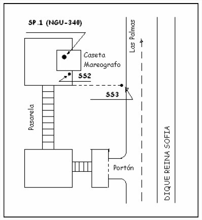
Benchmark positionning related to the tide gauge station
")
Benchmarks description table
Benchmarks vertical positionning diagram
Reference:
Leveling evolution

Download leveling data
TIDE GAUGE LOCAL LEVELING NETWORK DATA OF STATION Puerto de la Luz
-----------------------------------------------------------------------------------------------------
Benchmark Lat. Long. Height Year of determination St.dev Distance_to_TG
10chr (°) 14chr (°) 14chr (m) 10chr 22chr (m)10chr (m) 10chr
-----------------------------------------------------------------------------------------------------
NGU 340 ---- ---- 9.700 2004 0.00000 ----
PLUZ ---- ---- 13.393 2004 0.00100 ----
Co-located instruments
- GPS : Puerto de la Luz (PLUZ)
- Tide Gauge : LAS PALMAS C (PUERTO DE LA LUZ) (LPALM)
- Tide Gauge : LAS PALMAS, PUERTO DE LA LUZ (LPPDL)
- Tide Gauge : LAS PALMAS D (LASPD)
- GPS : Universidad de Las Palmas (ULP2)
Photo album