
SETE
Contributing agency


Station summarySETE


| IGS-type acronym : | SETE00FRA |
| Latitude : | 43.39763300 |
| Longitude : | 3.69910500 |
| Installed date : | 2007-10-26 |
| Decommissioned date : | 2024-06-13 |
| Country : | FRANCE |
| City: | SETE |
| Station status : | Decommissioned (white and red cross) |
| Distance to Tide Gauge (m) : | 2 |
| Domes Nr.: | 19940M001 |
| Station operator: |
BAUDIN Sandrine
|
| IGS-like station form : |
GPS position times seriesSETE
(Reference epoch: )
| M | Material change or malfunction |
| E | Earthquake |
| RF | Reference Frame change |
| U | Unknown |
| NA | Not available |
| Position discontinuity | |
| Velocity discontinuity |
Data available at SONELSETE
Quality plots on RINEX filesSETE
 |
 |
Plots generated using software developed with the EPN team at ROB |
| Observations & tracking performance | Satellite tracking |
 (this operation may take 20 to 45s)
The satellite tracking graph has been calculated for all stations for the first day of each month. If you wish to have a graph for another date, choose the 'Calculate a specific date' option.
Leveling & DatumsSETE
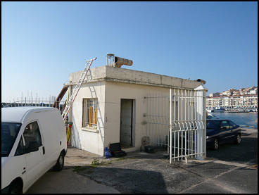
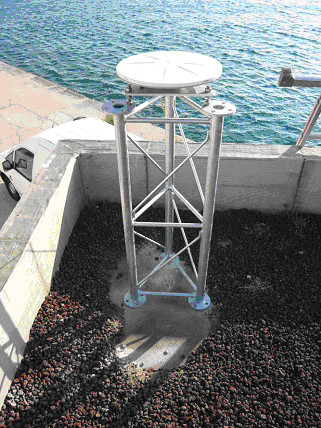
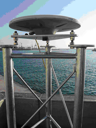
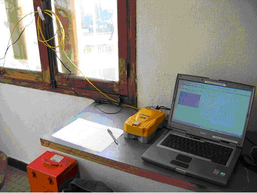
Photo albumSETE
BibliographySETE
If you have a relevant reference to suggest, please send-us an e-mail : sonel@sonel.org-
 Dodet, Bertin et al., 2019. Characterization of Sea-level Variations Along the Metropolitan Coasts of France: Waves, Tides, Storm Surges and Long-term Changes.


History of the stationSETE
The GPS installation at Sète is motivated by its relative proximity (about 14 km) to the ground track of the former Topex/Poseidon and current Jason radar altimetry satellites (see pictures at the tide gauge webpage, link below). In addition, historical tide gauge observations are reported at the nearby (250 metres) Saint-Louis lighthouse between 1850 and 1860.
Log bookSETE
2019/05/02 (02/05/2019)
Access to the new Trimble netr9 GNSS receiver installed at SETE is activated and oprational from La Rochelle. RINEX3 namming convention hace been modified in accordance with RGP requirements.
Station should be soon included in RGP network.
E. Poirier
2018/07/30 (19/04/2019)
S. Beaudin does not have any more remote access to the TopCOn GB1000 receiver of SETE. Data is still archived on SONEL but not on RENAG from this date. Montpellier used to send the data to RENAG.
E. Poirier
2019/01/04 (19/04/2019)
S.Baudin est en charge du GPS de Sete et d'envoyer les données à RENAG. Elle n'a plus accès au récepteur depuis le jour 211 (30/07/2017).
Elle avait auparavant des droits d'accès aux port 8002 et 21 pour les 2 IP suivantes: 162.38.141.55 et 162.38.142.215. Affaire en cours.
E.Poirier
2019/04/18 (19/04/2019)
New receiver Trimble netr9 installed in replacement of TopCon GB1000.
Job done by Sandrine Beaudin, geosciences Montpellier.
GNSS antenna cable issues and connecting issues.
E.Poirier


