
LEVELING OF AJACCIO
Benchmark positionning related to the tide gauge station
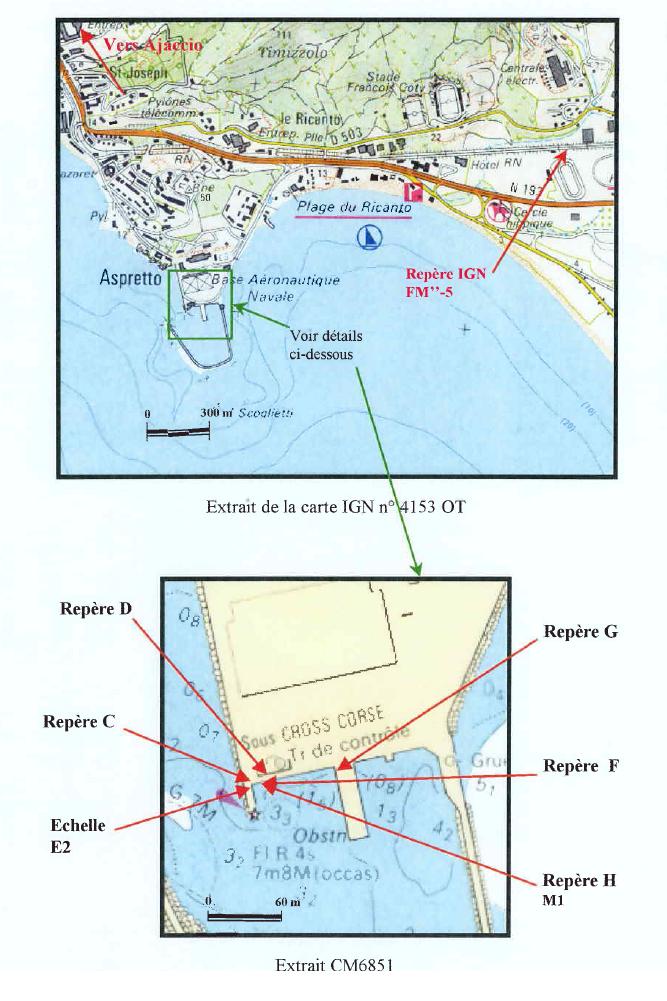


Benchmarks description table
Benchmarks vertical positionning diagram
Reference:
Leveling evolution
| Stand point | F | F | F | F | C | G | G | G | H | D | D | FM"-3 | g | ||
|---|---|---|---|---|---|---|---|---|---|---|---|---|---|---|---|
| End point | D | H | C | G | D | D | FM"-5 | AJAC | D | g | FM"-3 | D | AJAC | ||
| Distance (m) | ---- | ---- | ---- | 63 | ---- | ---- | 1771 | 520 | ---- | ---- | ---- | ---- | 6 | ||
| Height difference (m) | Campaign 7 | 2023-11-21 | --- | --- | --- | --- | --- | --- | --- | --- | --- | --- | --- | --- | --- |
| Campaign 6 | 2015-09-11 | --- | --- | --- | --- | --- | --- | --- | --- | --- | --- | --- | --- | --- | |
| Campaign 5 | 2013-06-20 | --- | --- | --- | --- | --- | --- | --- | --- | --- | --- | --- | --- | --- | |
| Campaign 4 | 2005-01-20 | 0.2940 ± 0.001 | --- | --- | --- | 0.2390 ± 0.001 | 0.2090 ± 0.001 | 1.5100 ± 0.001 | --- | 0.0560 ± 0.001 | --- | --- | --- | --- | |
| Campaign 3 | 2004-08-30 | 0.2943 ± 0.0001 | --- | --- | --- | --- | --- | --- | --- | --- | 48.1639 ± 0.0001 | --- | -6.4080 ± 0.001 | 1.6446 ± 0.001 | |
| Campaign 2 | 2000-06-01 | --- | 0.2720 ± 0.001 | 0.0560 ± 0.001 | 0.0860 ± 0.001 | --- | 0.2100 ± 0.001 | --- | --- | --- | --- | 6.4080 ± 0.001 | --- | --- | |
| Campaign 1 | 2000-01-17 | --- | --- | --- | --- | --- | --- | --- | 50.0200 ± 0.001 | --- | --- | --- | --- | 1.6446 ± 0.0001 | |
| Height difference evolution graph |  |  |  |  |  |  |  |  |  |  |  |  |  | ||
Download leveling data
TIDE GAUGE LOCAL LEVELING NETWORK DATA OF STATION Ajaccio
-----------------------------------------------------------------------------------------------------
Benchmark Lat. Long. Height Year of determination St.dev Distance_to_TG
10chr (°) 14chr (°) 14chr (m) 10chr 22chr (m)10chr (m) 10chr
-----------------------------------------------------------------------------------------------------
FM"-3 41.928806 8.767389 14.607 2004 0.00000 420
FM"-5 41.929194 8.783194 9.500 2023 0.00000 1720
C ---- ---- 7.957 2023 0.00200 ----
D ---- ---- 8.192 2023 0.00200 ----
F 41.922750 8.762861 7.903 2023 0.00200 520
G 41.922833 8.763611 7.984 2023 0.00200 520
H ---- ---- 8.143 2005 0.00200 ----
AJAC 41.927455 8.762611 58.011 2013 0.00000 0
g 41.927485 8.762553 56.363 2004 0.00200 10
L 41.922861 8.762750 10.622 2023 0.00200 510
I ---- ---- 8.079 2023 0.00200 ----
Q 41.925250 8.761111 15.760 2023 0.00100 280
O ---- ---- 9.259 2023 0.00200 ----
P ---- ---- 7.813 2023 0.00200 ----
FM"-3- VII41.926833 8.767056 14.457 2023 0.00200 370
FM"-4a 41.928750 8.770222 19.607 2023 0.00200 650
FM"-4b 41.927972 8.776194 10.174 2023 0.00200 1130
K 41.926944 8.799667 12.376 2023 0.00200 3070
J 41.928056 8.795611 14.134 2023 0.00200 2740
FM"-3a ---- ---- ---- ---- ---- ----
N ---- ---- ---- ---- ---- ----
Co-located instruments
- GPS : Ajaccio (AJAC)
- Tide Gauge : AJACCIO (AJACC)
- GPS : Campo Dell'Oro (CAMP)


