


Global Sea Level Observing System (GLOSS)
GLOSS Stations
The Global Sea Level Observing System (GLOSS) was established by the UNESCO Intergovernmental Oceanographic Commission (IOC) in 1985 to establish a well-designed, high-quality in situ sea level observing network to support a broad research and operational user base.
GLOSS provides oversight and coordination for global and regional sea level networks that supports the oceanographic and climate research communities based on feedback and direction from within these communities. GLOSS remains under the auspices of the IOC and is one of the observing components under the World Meteorological Organization (WMO)/ IOC Joint Technical Commission for Oceanography and Marine Meteorology (JCOMM).
GLOSS contributes to the Global Ocean Observing System (GOOS), particularly its climate, coastal and operational service modules, through the progressive development of the sea level measurement network, data exchange and collection systems, and preparation of sea level products for various user groups.
For a complete description of the GLOSS program, see the latest GLOSS Implementation Plan.

The GLOSS Core Network (GCN)
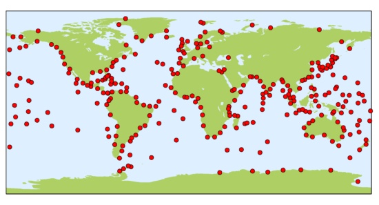
The backbone of the global tide gauge network is the GLOSS Core Network (GCN), a global set of 300 tide gauge stations that provide optimal sampling of the global ocean. GCN gauges were allocated to each island or group of islands at intervals not closer than 500 km, and along continental coasts at intervals generally not less than 1000 km. Preference was given to islands in order to maximize exposure to the open ocean.
Maps showing the status of the data streams from each GCN station can be found on the PSMSL website here: status maps.
A list of the GCN stations can be found here, and the locations of the current GCN are shown in the figure below. The various GLOSS data centers provide different types of data for each station with different resolutions and levels of quality-control. A good place to start is the GLOSS Station Handbook, where clicking on a particular station and following the link to the station page will provide links to the different time series available for that station.
Click on the map (above) to see the overall operational status of the GLOSS core.
Role of SONEL
SONEL is the dedicated center for Global Navigation Satellite System (GNSS) data at or near tide gauge stations. This data is essential for studies of sea level change, as it provides information about how the tide gauge is moving in three-dimensional space. The vertical movement of the gauge will register as local sea level change, but these changes are not related to the height of the ocean surface. SONEL is supported by the University of La Rochelle and the French CNRS/INSU institute. SONEL provides information about the status of GNSS stations at or nearby tide gauges through a web-based monitoring facility. It assembles, archives, and distributes GNSS observations and metadata from GLOSS and non-GLOSS tide gauge sites from around the world. The data can be accessed through the web-based facility, as well as anonymous FTP server.
Other data centers
GLOSS is a global endeavor requiring the coordinated participation of an international group of agencies. In addition to SONEL, the following data centers provide complimentary GLOSS data streams while helping to shape the future of the global in situ sea level observing network. In general, GLOSS data centers are associated with scientists involved with sea level research, which helps to maximize the quality of GLOSS datasets.
Permanent Service for Mean Sea Level (PSMSL)

Established in 1933, the Permanent Service for Mean Sea Level (PSMSL) has been responsible for the collection, publication, analysis and interpretation of sea level data from the global network of tide gauges. It is based in Liverpool at the National Oceanography Centre (NOC). The PSMSL archive is comprised of ‘delayed-mode’ monthly mean sea level values most suitable for studies of long-term sea-level change, and most studies of 20th century global sea level rise are based on the PSMSL data set.
University of Hawaii Sea Level Center (UHSLC)

The UHSLC operates the GLOSS Fast-Delivery Center, which is responsible for assembling and distributing a version of GLOSS sea level data that has undergone preliminary quality control by Member Nations and includes supporting metadata information. “Fast-Delivery” implies posting of the data within 1-2 months. The UHSLC provides Fast-Delivery quality control services for Member States that do not have that capability. The Joint Archive for Sea Level (JASL) hosted by the UHSLC acquires hourly datasets from GLOSS and non-GLOSS tide gauges from around the world that have received a final quality assessment from the data originators. JASL provides an independent check of the data, primarily to identify any remaining outliers, timing issues, or datum shifts. Any quality issues with the data are brought to the attention of the data originators for reconciliation. JASL then assembles a single hourly time series for each station, or a series of sub-records if datum changes occur over time. The JASL dataset therefore represents a “data product”, as problematic data points are not simply flagged and left in the records as they are by BODC for the GLOSS Delayed Mode Dataset, but changes to the data actually are implemented by JASL analysts (e.g., level adjustments, timing shifts, outlier removal). These changes are documented in the metadata information.
British Oceanographic Data Center (BODC)
The GLOSS Delayed Mode Data Centre is operated by the BODC in collaboration with PSMSL. It has the responsibility for assembling, quality controlling and distributing the “final” version of GLOSS sea-level data sets, as well as all supporting metadata information. The Delayed Mode Centre handles hourly (or sub-hourly) values, together with ancillary variables (e.g. atmospheric pressure) where these are available, from the GCN, GLOSS-LTT, and GLOSS-OC databases. PSMSL generally relies on Member Nations to provide the final version of the monthly time series with all quality control assessments applied and documented. The Delayed Mode Centre will, on request from member nations, form and provide the PSMSL with monthly averages based on the final data sets received.
IOC Sea Level Station Monitoring Facility

The Flanders Marine Institute (VLIZ, Belgium) hosts a Sea-Level Station Monitoring Facility that includes GLOSS Core stations. VLIZ provides a web-based global sea-level station monitoring service for viewing sea-level data received in real-time from different network operators primarily via the GTS, but also through other communications channels. The service provides information about the operational status of GLOSS stations through quick inspection of the raw data stream. The sea-level station monitoring system also runs a web-service for direct data access. The sea-level station catalogue system developed and maintained at VLIZ links sea-level station metadata repositories.
In addition to its national scope with its specific aims associated with a national research observation infrastructure on sea level, SONEL plays the role of GNSS at tide gauge data assembly centre for the GLOSS programme since 2011 (see GLOSS Implementation Plan - 2012, pp. 23). SONEL is also the primary data centre for the GPS Tide Gauge Benchmark Monitoring (TIGA) pilot project, which has turned into a working group of the International GNSS Service (IGS) in 2010.
Consequently, SONEL provides information about the status of GNSS stations at or nearby tide gauges around the globe through a web-based monitoring facility (e.g., dynamic maps). It assembles, archives, and distributes GNSS observation and metadata from permanent stations at or near tide gauges distributed worldwide. In the latest implementation plan, GLOSS relies on TIGA (IGS) and SONEL for the assembling, processing and distribution of GNSS data at tide gauges. GLOSS works with TIGA (IGS) to define the useful sea-level oriented products of GNSS analyses and its most appropriate standards and formats for distribution to the sea-level community, concise while informative and complete.
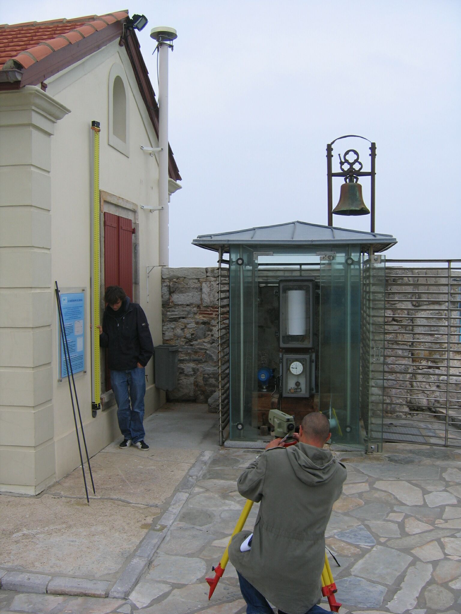
Key to this endeavor will be the maintenance of survey records linking the GNSS antenna to the tide gauge benchmark. Towards this aim, SONEL has started coordinating with the PSMSL to make this important metadata available for all GLOSS stations (Click on the image for further information).
All tide gauge operators, whether associated with GLOSS or not, are welcome to have their GNSS (GPS) data and metadata included in the SONEL data center facility for ensuring state-of-the-art processing (e.g., by the TIGA data analysis centres). GLOSS national contacts have the responsibility to ensure that the GLOSS requirements are fulfilled at the stations for which the country has committed. The requirements include a GNSS antenna located as close to the gauge as possible (IOC Manuals & Guides, No. 14 (IV), pp. 52).
– First Progress Report on the GNSS at Tide Gauge Activities: SONEL Data Holdings & Tools to access the data, presented at the XIIIth GLOSS group of experts meeting, hosted by the PSMSL, Liverpool (United Kingdom), 30 October to 1st November 2013.
– Second Progress Report on the GNSS at Tide Gauge Activities: SONEL Data Holdings & Tools to access the data, presented at the XIVth GLOSS group of experts meeting, hosted by the National Institute of Oceanography, Goa (India), 21-23 October 2015.
– Third Progress Report on the GNSS at Tide Gauge Activities: SONEL Data Holdings & Tools to access the data, presented at the XVth GLOSS group of experts meeting, hosted by the University of Columbia, New York (USA), 8-9 July 2017.
– Fourth Progress Report on the GNSS at Tide Gauge Activities: SONEL Data Holdings & Tools to access the data, presented at the XVIth GLOSS group of experts meeting, hosted by the Korean Hydrographic and Oceanographic Agency, Busan (Republic of Korea), 11-13 April 2019.
Below is a list of the GNSS data providers ordered by country. For each provider, it gives the acronym of the associated GNSS stations. Note that the work is under progress to have a complete list. However, do not hesitate to contact us to keep it updated.
E-mail: sonel@sonel.org
| COUNTRY (58) | PROVIDER (230) | ACRONYM | GNSS stations (1354) |
|---|---|---|---|
| Geospatial Information Authority of Japan | GSI | (49) | |
| Service Hydrographique et Océanographique de la Marine | SHOM | (7) | |
| National Oceanic and Atmospheric Administration | NOAA | (13) | |
| Instituto Geografico Nacional | IGNE | (44) | |
| Institut Polaire Français Paul Emile Victor | IPEV | (4) | |
| Geoscience Australia | GA | (77) | |
| National Geodetic Survey | NGS | (15) | |
| Puertos del Estado | PDE | (10) | |
| University of Hawai'i Sea Level Centre | UHSLC | (12) | |
| UNAVCO | UNAVCO | (92) | |
| Delft University of Technology | TUDELFT | (4) | |
| Istituto Nazionale di Geofisica e Volcanologia | INGV | (14) | |
| Instituto Geografica Nacional de la Republica Argentina | IGNRA | (5) | |
| Korea Astronomy and Space Science Institute | KASI | (5) | |
| Instituto de Geofísica - Servicio Mareográfico Nacional - UNAM | SMN-UNAM | (17) | |
| Laboratoire de Géologie de l’Ecole normale supérieure | GEOL-ENS | (3) | |
| Instituto Nacional de Estadística y Geografía | INEGI | (6) | |
| Bundesanstalt für Gewässerkunde | BAFG | (48) | |
| Institut de Physique du Globe de Paris | IPGP | (5) | |
| Centro GNSS de Canarias | CGC | (1) | |
| Agenzia Spaziale Italiana | ASI | (9) | |
| Centre d'Etudes Techniques Maritimes et Fluviales | CETMEF | (7) | |
| National Oceanography Centre | NOC | (10) | |
| Instituto de Estadística y Cartografía de Andalucía | IECA | (6) | |
| Gipuzkoako Foru Aldundia | GFA | (1) | |
| National Mapping and Resource Information Authority | NAMRIA | (23) | |
| Instituto Brasileiro de Geografia e Estatística | IBGE | (21) | |
| Korea Hydrographic and Oceanographic Administration | KHOA | (8) | |
| National Geo-Spatial Information | NGI | (10) | |
| Réseau National GPS permanent | RENAG | (16) | |
| Norwegian Mapping Authority - Kartverket | NMA | (21) | |
| Deutsches Geodätisches Forschungsinstitut | DGFI | (2) | |
| DTU Space National Space Institute | DTU-Space | (14) | |
| LIENSs - OASU | LIENSs-OASU | (22) | |
| Centre National de la Recherche Scientifique | CNRS | (20) | |
| ASG-EUPOS | ASG-EUPOS | (5) | |
| U.S. Coast guard | USCG | (39) | |
| Jet Propulsion Laboratory | JPL | (50) | |
| Bundesamt für Kartographie und Geodäsie | BKG | (21) | |
| Ordnance Survey Ireland | OSI | (6) | |
| Departamento de Geofísica, Centro Sismologico Nacional, Univ. de Chile | DGF-CSN | (1) | |
| Department of Survey and Mapping Malaysia | JUPEM | (6) | |
| Louisiana State University - Center for GeoInformatics | LSU-C4G | (6) | |
| North Carolina Geodetic Survey | NCGS | (7) | |
| Connecticut Department of Transportation | CT-CONDOT | (1) | |
| SmartNet North America | SMRTNT | (10) | |
| Alabama Department of Transportation - Alabama Great Seal | ALDOT | (2) | |
| Texas Department of Transportation | TxDOT | (4) | |
| NYS Spacial Reference Network | NYSDOT | (1) | |
| Indian Space Research Organisation - Telemetry Tracking and Command Network | ISTRAC-ISRO | (3) | |
| Instituto Geografico Agustin Codazzi | IGAC | (3) | |
| Institut Cartografic i Geologic de Catalunya | ICGC | (1) | |
| TERIA | TERIA | (24) | |
| Massachusetts Department of Transportation | MassDOT | (3) | |
| Maine Department of Transportation | MaineDOT | (2) | |
| Virginia Department of Transportation | VDOT | (1) | |
| State of Alaska, Department of Transportation Central Region Survey Section | AK-DOT | (2) | |
| Geological Survey of Canada | GSC | (14) | |
| Japan Aerospace Exploration Agency | JAXA | (1) | |
| Instituto Geografico Nacional Tommy Guardia | IGNTG | (2) | |
| Ordnance Survey Geodesy and Positioning | OS | (38) | |
| Kadaster | NSGI | (11) | |
| Diputacion Foral de Vizcaya | DFV | (2) | |
| Real Instituto y Observatorio de la Armada | RIOA | (3) | |
| Servicio de Informacion Territorial de las Islas Baleares | SITIB | (2) | |
| GRAFCAN | GRAFCAN | (7) | |
| Observatoire de Recherche Méditerranéen de l'Environnement | OREME | (2) | |
| Puerto Rico Seismic Network | PRSN-UPRM | (6) | |
| Lamont-Doherty Earth Observatory | LDEO | (2) | |
| EarthScope Consortium | EC | (6) | |
| Institute of Astronomy University of Latvia | LUAI | (1) | |
| INSTITUTO GEOGRAFICO MILITAR Uruguay | IGM-Ur | (3) | |
| Queensland Department of Environment and Science | DESI-QLD | (11) | |
| NSW Spatial Services | NSW-SS | (13) | |
| German Aerospace Center | DLR | (1) | |
| Nationaal Geografisch Instituut | NGI | (1) | |
| Maritieme Dienstverlening en Kust | MDK | (1) | |
| Chalmers University of Technology | CUT | (1) | |
| Onsala Space Observatory | OSO | (1) | |
| Badan Informasi Geospasial | BIG | (14) | |
| Department of Transport and Main Roads QLD | TMR - QLD | (7) | |
| Department of Natural Resources and Mines, Manufacturing, and Regional and Rural Development - Queensland | NRMMRRD-QLD | (3) | |
| Department of Transport and Planning - Victoria | DTP-VIC | (1) | |
| Marine Institute | MI | (2) | |
| Agency for Data Supply and Infrastructure | SDFI | (24) | |
| Instituto Geofisico de Escuela Politécnica Nacional | IGEPN | (4) | |
| Centro Sismologico Nacional | CSN | (13) | |
| The Canadian High Arctic Ionospheric Network | CHAIN | (1) | |
| Laboratoire de l'Atmosphère et des Cyclones | LACY | (1) | |
| Digitaal Vlaanderen | DV | (7) | |
| British Columbia Active Control System | BCACS | (3) | |
| National Observatory of Athens | NOA | (6) | |
| South Carolina Geodetic Survey | SCGS | (3) | |
| National Park Service | NPS | (3) | |
| Institut Cartogràfic Valencià | ICV | (1) | |
| Ultimate Positionning Group | UPG | (6) | |
| RTK NetWest | RTK NetWest | (1) | |
| Observatoire des Sciences de la Réunion | OSU-R | (1) | |
| Direction Affaires Foncières | DAF | (1) | |
| Michigan State University | MSU | (1) | |
| Hilcorp Energy Company | HEC | (2) | |
| ARG | Estacion Astronomica Rio Grande | EARG | (3) |
| AUS | Department of Environment & Primary Industries | DEPI | (3) |
| AUS | LANDGATE | LANDGATE | (5) |
| AUS | Department Infrastructure, Planning & Logistics | DIPL | (2) |
| AUS | IPS Radio and Space Services - Australia Bureau of Meteorology | IPS | (1) |
| AUS | Australian Surveying & Land Information Group | AUSLIG | (1) |
| AUS | Curtin University | Curtin University | (1) |
| BEN | Institut Geographique National du Benin | IGN-BJ | (1) |
| BOL | INSTITUTO GEOGRAFICO MILITAR DE BOLIVIA | IGM-Bo | (1) |
| BRA | Instituto Nacional de Pesquisas Espaciais | INPE | (1) |
| BRB | Coastal Zone Management Unit | CZMU | (2) |
| CAN | National Resources Canada | NRCan | (30) |
| CAN | SERVICE NOVA SCOTIA | SNS | (4) |
| CAN | Dept. Internal Services | ISD | (1) |
| CHE | Swiss Federal Office of Topography | SWISSTOPO | (1) |
| CHL | Center for Space Studies | CEC | (2) |
| CHL | Universidad de Concepcion | UdeC | (1) |
| CHL | Universidad de Antofagasta | UANTOF | (1) |
| CHL | Universidad de Santiago de Chile | USACH | (1) |
| COL | Servicio Geologico Colombiano | SGC | (1) |
| CPV | Instituto Nacional de Meteorologia e Geofisica | INMG | (1) |
| CRI | Registro Nacional Republica Costa Rica | RNP | (3) |
| CYM | Cayman Land Info | CAYMAN | (1) |
| DEU | Deutsches GeoForschungsZentrum | GFZ | (21) |
| DNK | Danish Geodata Agency | GST | (1) |
| DOM | Universidad Nacional Pedro Henriquez Ureña | UNPHU | (3) |
| ECU | Instituto Geografico Militar Ecuador | IGM_EC | (2) |
| EGY | Centre d'Etudes Alexandrines | CEAlex | (2) |
| ESP | Instituto Espanol de Oceanografia | IEO | (1) |
| ESP | Geodetic Department Universtidad de Cantabria | UC | (1) |
| ESP | Department of Applied Geodesy - Aranzadi Society of Sciences | ADAG | (1) |
| EST | Estonian Land Board | ELB | (15) |
| FIN | Finnish Geospatial Research Institute, National Land Survey of Finland | FGI-NLS | (5) |
| FRA | Institut National de l'Information Géographique et Forestière | IGN | (39) |
| FRA | Laboratoire d'Etudes en Geophysique et Oceanographie Spatiale | LEGOS | (10) |
| FRA | Direction des Infrastructures, de la Topographie et des Transports Terrestres | DITTT | (8) |
| FRA | Port Autonome de Nantes - Saint-Nazaire | PANSN | (1) |
| FRA | Centre National d"Etudes Spatiales | CNES | (23) |
| FRA | ORPHEON | ORPHEON | (1) |
| FRA | ACTIPLAN SARL | ACTIPLAN | (4) |
| FRA | SATINFO Réseau GNSS | SAT-INFO | (10) |
| FRA | GIE Coop&Tech - Réseau RTK - Groupement de Cooperatives Agricoles | GIE Coop&Tech | (3) |
| FRA | Ville de Nice | Ville de Nice | (1) |
| FRA | Grand Port Maritime du Havre | HAROPA | (3) |
| FRA | Communauté Urbaine de Dunkerque | CUD | (1) |
| FRA | Ville de Cannes - Direction des systèmes d'information Géographique | Ville de Cannes | (3) |
| FRA | Ecole Normale Superieure / CNRS - Laboratoire de Geologie | ENS-GEOLOLOGIE | (1) |
| FRA | IPG - Observatoire volcanologique du Piton de la Fournaise | IPG | (1) |
| FRA | DTAM - Phares et Balises | DTAM | (2) |
| FRA | Météo France | MF | (1) |
| FRA | Grand Port Maritime de Nantes | GPMN | (1) |
| FRA | Service des Phares et Balises de Guyane | DM-GUYANE | (2) |
| FRA | Institut National de l'Information Géographique et Forestière | IGN | (1) |
| FRA | GéoAzur - Observatoire de la Cote d'Azur | GeoAzur - OCA | (1) |
| FRA | Conseil départementale des Pyrénées Atlantiques | CDPA | (1) |
| GBR | NERC British Isles continuous GNSS Facility | BIGF | (15) |
| GBR | Bermuda Institute of Ocean Science | BIOS | (1) |
| GBR | European Space Agency | ESA | (1) |
| GRC | DEPARTMENT of GEODESY & SURVEYING | DGS | (1) |
| GRC | National Technical University of Athens | NTUA | (1) |
| GRC | Hellenic National Tsunami Warning Centre | HL-NTWC | (1) |
| GRC | Technical University of Crete | TUC | (3) |
| HKG | Lands Department - Hong-Kong | LD-HK | (12) |
| HRV | Hydrographic Institute of the Republic of Croatia | HHI | (1) |
| HRV | State Geodetic Administration | SGA | (4) |
| IDN | National Coordination Agency for Surveys and Mapping | BAKOSURTANAL | (2) |
| IRN | National Cartographic Center of I.R.IRAN | NCC | (1) |
| ISR | Survey of Israel (SOI) | SOI | (2) |
| ITA | Università degli Studi di Ferrara | UNIFE | (1) |
| ITA | Consiglio Nazionale delle Ricerche - Istituto di Scienze Marine | CNR- ISMAR | (3) |
| ITA | Regione Campania | RC | (1) |
| ITA | Regione Abruzzo | RAbruzzo | (1) |
| ITA | Cooperativa San Martino | COOPSM | (1) |
| ITA | e-geos S.p.A. - una societa ASI/Telespazio | TPZ | (3) |
| ITA | INAF ASTRONOMICAL OBSERVATORY OF CAGLIARI | CAO | (1) |
| ITA | Universita' di Cagliari - Dip. Ingegneria Strutturale - Sez. Topografia | DISIG-Cagliari | (1) |
| KOR | National Geographic Information Institute | NGII | (1) |
| LKA | Surveyor General's Office Colombo | SGOC | (1) |
| LTU | Geodetic Institute of Vilnius TU | VGTU GI | (1) |
| LUX | University of Luxembourg | UL | (5) |
| LVA | Latvijas Geotelpiskas Informacijas Agentura | LGIA_LatPOS | (2) |
| MDG | Institute Observatory of Geophysics of Antananarivo | IOGA | (1) |
| MDV | Gan Meteorological Office | GANMET | (1) |
| MEX | Instituto Municipal de Investigación y Planeación de Ensenada | IMIP | (1) |
| NAM | Directorate of Survey and Mapping Namibia | DSM-NAM | (1) |
| NZL | GNS Science - GeoNet | GNS - GEONET | (26) |
| NZL | Land Information New Zealand | LINZ | (13) |
| NZL | University of Otago | uOtago | (2) |
| OMN | Petroleum Development Oman | PDO | (1) |
| PER | Instituto geografico del peru | IGN PERU | (1) |
| PHL | Naval Forces West | NFW | (1) |
| PHL | Mindanao State University | MSU | (1) |
| POL | Space Research Centre of the Polish Academy of Sciences | SRC-PAS | (1) |
| PRT | Space & Earth Geodetic Analysis Laboratory | SEGAL | (3) |
| PRT | Direccao de Servicos de Cartografia e Informacao Geografica | DSCIG | (1) |
| PRT | Direcao-Geral do Territorio | DGT | (3) |
| PYF | Université de la Polynesie francaise | UPF | (10) |
| ROU | National Institute for Earth Physics | NIEP | (2) |
| ROU | National Center for Cartography - ROMPOS Bureau | NCC - ROMPOS | (1) |
| RUS | SmartNet Russia | SMARTNET | (1) |
| RUS | Research Station of RAS | RS-RAS | (9) |
| RUS | Geophysical Observatory Arti | ARS | (1) |
| SEN | Universite Cheikh Anta Diop | UCAD | (1) |
| SEN | Direction des Travaux Geographiques et Cartographiques | ANAT/DTGC | (1) |
| SGP | Nanyang Technological University | NTU | (1) |
| SGP | Singapore Land Authority | SLA | (5) |
| SGP | Earth Observatory of Singapore | Singapore EO | (1) |
| SVN | Surveying and Mapping Authority of the Republic of Slovenia | SMARS | (1) |
| SWE | SWEPOS-LANTMÄTERIET | SWEPOS-LMV | (46) |
| TWN | National Measurement Laboratory ; Industrial Technology Research Institute | NML - ITRI | (2) |
| TWN | Institute of Earth Sciences, Academia Sinica | IES | (5) |
| TZA | Tanzania Ports Authority | TPA | (1) |
| URY | Servicio geographico militar | SGM | (2) |
| USA | US Geological Survey | USGS | (12) |
| USA | University of California - Berkeley Seismological Laboratory | UC-BSL | (6) |
| USA | U.S. Naval Observatory | USNO | (4) |
| USA | National Radio Astronomy Observatory | NRAO | (5) |
| USA | University of the Virgin Islands | UVI | (2) |
| USA | Plate Boundary Observatory - EarthScope | PBO | (5) |
| USA | Federal Aviation Administration | FAA | (3) |
| USA | University of Maryland, Baltimore County | UMBC | (1) |
| USA | Washington State Reference Network | WSRN | (4) |
| USA | National Geospatial-Intelligence Agency | NGA | (7) |
| USA | CICESE Laboratorio del Nivel del Mar | CICESE | (1) |
| USA | University of Maine at Machias | UMM | (1) |
| USA | UNITED STATES AIR FORCE | USAF | (1) |
| USA | Scripps Orbit and Permanent Array Center | SOPAC | (1) |
| USA | Pacific GPS Facility - Hawaii Institute of Geophysics and Planetology - University of Hawaii at Manoa | PGF | (15) |
| USA | Florida Department of Transportation | FDOT | (10) |
| USA | The Surveyors Exchange | SUREX | (1) |
| VEN | Centro de Procesamiento y Analisis GNSS SIRGAS de LUZ | CPAGS-LUZ | (1) |
| ZAF | The Hartebeesthoek Radio Astronomy Observatory | HartRAO | (4) |
This graph shows the evolution of the number of Rinex files available on SONEL (per DOY) since 1990-079.
Observation stations contributing to GLOSS
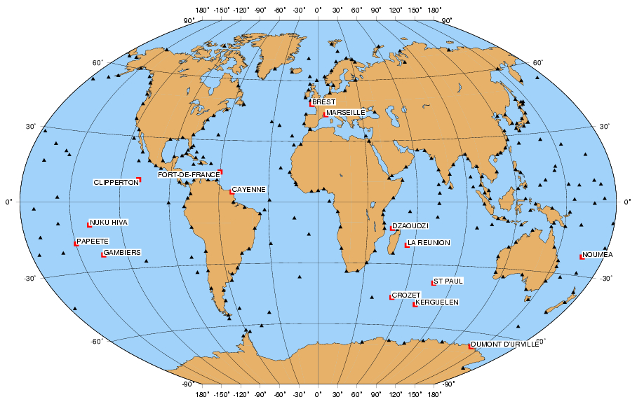
The map on the right shows the French stations contributing to the GLOSS core network of stations, a contribution which was agreed by France when the programme was started at the beginning of the 1980s. Despite its heritage and the wealth of sea level data, the French contribution to the world programme appears relatively modest. There are numerous organisations which use the tide gauges in France as part of their missions. Nevertheless the French contribution is ambitious given the geographical extent of its territories (see map), which raises numerous technical and administrative difficulties.
Today, there is a favourable context for the participation of France in GLOSS. On one hand, SHOM became an “Etablissement Public” (Governmental Agency) in May 2007 and its mission was extended to providing support for the state’s maritime policy, which has opened up new perspectives for taking into account all water level measurement applications, both in terms of the observations and in making the data available, together with assuming the national coordination of tide gauge management based on what is already in place (SONEL, ROSAME etc.). This opening was further reinforced in 2010 by a Prime Minister instruction of 20 April 2010 (fr). On the other hand, SONEL has been acknowledged as a national research observation infrastructure (“Service d’observation”) on coastal sea level by the National Institute for Earth Sciences and Astronomy (INSU) in 2011.
GNSS at tide gauge data assembly centre for GLOSS
In addition to its national scope with its specific aims associated with a national research observation infrastructure on coastal sea level, SONEL plays the role of GNSS at tide gauge data assembly centre for the GLOSS programme since 2011. Hence it represents one of the five global data centres of the GLOSS programme (see GLOSS Implementation Plan - 2012, pp. 23). The GNSS observational complement to tide gauge data is key to understanding sea level change and variability.
National report of France to the GLOSS group of experts
– Report of France to the VIIIth GLOSS GE Meeting, UNESCO, Paris, 13-17 October 2003.
– Report of France to the IXth GLOSS GE Meeting, UNESCO, Paris, 24-25 February 2005.
– Report of France to the Xth GLOSS GE Meeting, UNESCO, Paris, 5-8 June 2007.
– Report of France to the XIth GLOSS GE Meeting, UNESCO, Paris, 13-15 May 2009.
– Report of France to the XIIth GLOSS GE Meeting, UNESCO, Paris, 9-11 November 2011.
– Report of France to the XIIIth GLOSS GE Meeting, PSMSL, Liverpool, 30 October - 1st November 2013.
– Report of France to the XIVth GLOSS GE Meeting, National Institute of Oceanography, Goa, 19 - 23 October 2015.
– Report of France to the XVth GLOSS GE Meeting, Columbia University, New York, 8-9 July 2017.
– Report of France to the XVIth GLOSS GE Meeting, KHOA, Busan, Republic of Korea, 11-13 April 2019.


