
LA ROCHELLE
Contributing agency


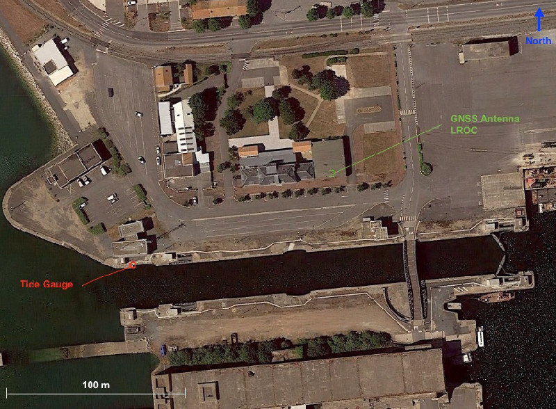
Station summaryLROC


| IGS-type acronym : | LROC00FRA |
| Latitude : | 46.15894600 |
| Longitude : | -1.21931100 |
| Installed date : | 2001-11-23 |
| Decommissioned date : | |
| Country : | FRANCE |
| City: | LA ROCHELLE |
| Station status : | active (green) |
| Distance to Tide Gauge (m) : | 122 |
| Domes Nr.: | 10023M001 |
| Station operator: | (RENAG) - Réseau National GPS permanent (LIENSs-OASU) - LIENSs - OASU |
| IGS-like station form : |
GPS position times seriesLROC
(Reference epoch: )
| M | Material change or malfunction |
| E | Earthquake |
| RF | Reference Frame change |
| U | Unknown |
| NA | Not available |
| Position discontinuity | |
| Velocity discontinuity |
Data available at SONELLROC
Quality plots on RINEX filesLROC
 |
 |
Plots generated using software developed with the EPN team at ROB |
| Observations & tracking performance | Satellite tracking |
 (this operation may take 20 to 45s)
The satellite tracking graph has been calculated for all stations for the first day of each month. If you wish to have a graph for another date, choose the 'Calculate a specific date' option.
Comparison with satellite altimetry data
- Link to Sea Level Differences (Satellite altimetry minus tide gauge data).
Co-located instrumentsLROC
- Tide gauge : LA ROCHELLE (LROCH)
Leveling & DatumsLROC
Photo albumLROC
BibliographyLROC
If you have a relevant reference to suggest, please send-us an e-mail : sonel@sonel.org-
 Chupin, Ballu et al., 2020. Mapping Sea Surface Height Using New Concepts of Kinematic GNSS Instruments. Remote Sensing.


-
Dodet, Bertin et al., 2019. Characterization of Sea-level Variations Along the Metropolitan Coasts of France: Waves, Tides, Storm Surges and Long-term Changes.
-
Garayt, 2002. Réseau GPS permanent - Station de La Rochelle « LROC » .
-
Gouriou, 2012. Evolution des composantes du niveau marin à partir d'observations de marégraphie effectuées depuis la fin du 18ème siècle en Charente-Maritime. Université de la Rochelle.
-
Vu, Frappart et al., 2018. Multi-Satellite Altimeter Validation along the French Atlantic Coast in the Southern Bay of Biscay from ERS-2 to SARAL. Remote Sensing.
History of the stationLROC
- Station implantée en 2001 sur le toit du bunker des archives du port de La Pallice. Le récepteur et l'ordinateur sont pendant longtemps dans le laboratoire photo du bunker.
- En 2015 la nouvelle maison du port est crée et reçoit tout le personnel du port. Le bunker et le bâtiment attenant sont mis en location à REEL, société de mécanique offshore.
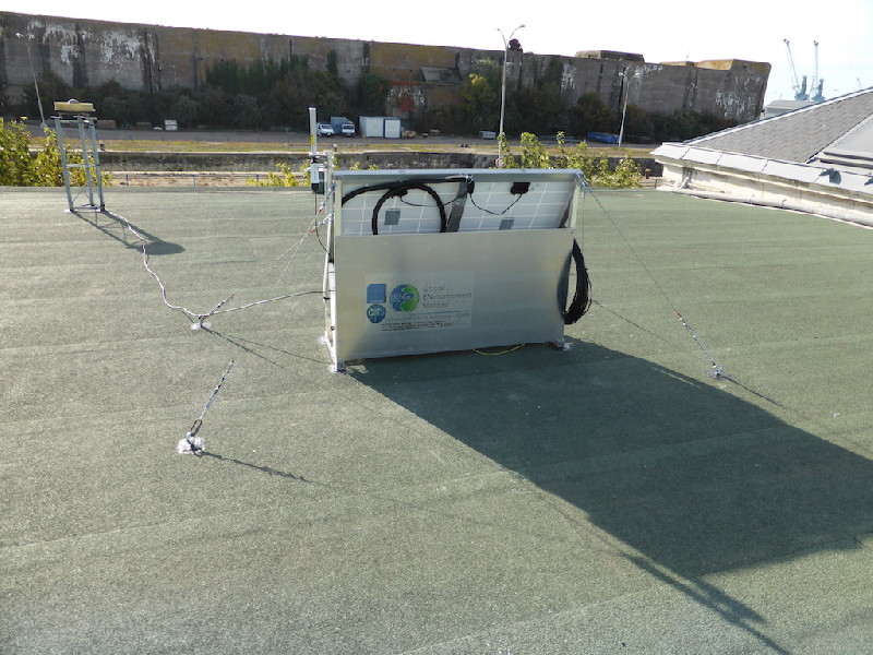
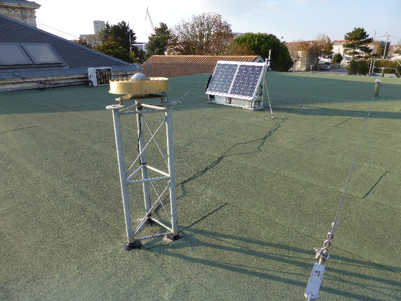
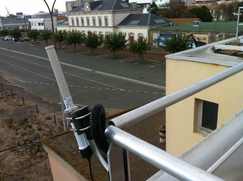
- Nous changeons de récepteur et l'installons sur le toit, alimenté par panneaux solaires et connecté au réseau du port par un pont wifi vers la maison de l'Ecluse.
Log bookLROC
2024-09-11 (04/11/2024)
No data and no communication with the station.
After contacting David NEVEUR of Port Atlantique La Rochelle, we found the reason, they were working on network communication.
After this maintenance, the station was not available, Mr. NEVEUR had to disconnect and reconnect the station cable.
September 24 , 2024 : the station is operating again. No data loss!
2022-11-16 (16/11/2022)
Since day 2022-285 (12 octobre 2022), the LROC station came out of a long period of good functioning. David NEVEUR from the harbour and I made a first intervention but 2 weeks later, wa had the same problem.
The receiver and antenna are still operational. The problem seems to be the power injector between switch and antenna for wifi bridge which feel it burn. I will soon come again to change it. V. Kerebel
2022-01-26 (23/05/2022)
Quick visite of the tide gauge site. The SHOM made modifications on their tide gauge site :
- Installation of a new radar from latest generation
- Changing of the tide gauge acquisition receiver (latest generation)
- Installation of a meteorological sensor and a camera
The GNSS site is working well.
2021-05-04 (04/05/2021)
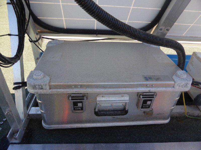
Quick visit at LROC GNSS site before heavy rain. N-TNC connector installed at Zarges box. Everything Ok. E.Poirier
2021-04-20 (04/05/2021)
Troubleshooting at LROC GNSS station due to satellite tracking loss raised that GNSS cable was broken. New LMR400 GNSS cable has been installed with 2 N-TNC connectors. Problem solved. E.Poirier/ C. Voisinne
2021-04-13 (13/04/2021)
Quick visit to the station with C.Voisinne (intern). Everything looks ok.E. Poirier
2021-01-27 (27/01/2021)
Safety line changed and paid by Port authorities in 2019. Access to the roof for GNSS maintenance is possible. Notification received today only which explains the delay. E. Poirier
2019-08-21 (21/08/2019)
From the 20th to 21st of August 2019, the absolute gravimeter FG5 has been deployed by N.Le Moigne and E.Poirier inside the bunker above the corresponding benchmark for 24h. This has been carried out thanks to the collaboration of REEL now occupying the place.
2019/04/18 (19/04/2019)
Because of EUREF notifications mails since day 106/2019, regarding the serial number of the GNSS antenna:
| DOY | ERROR TYPE | SITE LOG / EXPECTED| RINEX V.2 HEADER | RINEX V.3 HEADER |
---------------------------------------------------------------------------
|106/2019|ANTENNA SN |13801 |13801 |CR620013801 |
It has been decided to change the short serial number of the antenna 13801 to the long one CR620013801.
I did a mistake because I created a 4.2 section in the sitelog to create a 'new antenna' with the long S/N.
I received this email from Dominique EPN:
"
Une mise à jour du fichier log de la station LROC00FRA a été soumise aujourd'hui via M3G.
Une nouvelle section 4.2 a été créée dans le but de corriger le SN de l'antenne.
Mais ce n'était nécessaire, ni souhaité. Une simple correction de la section 4.1
était préférable. Pourriez-vous modifier à nouveau le fichier log en supprimant
la section 4.2 ? Merci d'avance.
"
Therefore I just modified section 4.1 and erased 4.2
E.Poirier
2019/04/17 (17/04/2019)
New firmware 4.31.101 installed to replace 4.20.232.
E.Poirier
2019/04/16 (17/04/2019)
Tracking of Beidou desactivated at 13:39Z. E.Poirier
The reason is:
Dear Etienne,
Since you have activated BeiDou tracking in LROC, the Galileo tracking has degraded, especially at low elevations. We have seen this behavior in other EPN stations equipped with a LEICA GR25. For EPN stations, we recommend to disable BeiDou in favor of Galileo because Galileo observations are used in our operational data analysis while BeiDou observations are not.
Best regards,
Carine
--
Carine Bruyninx
2019/04/10 (17/04/2019)
Tracking of Beidou activated at 14:03Z. E.Poirier
2019/03/05 (05/03/2019)
New streaming of MDB and RINEX3 data directly from the receiver to IGN and ENSG data centres.
2019-01-17 (17/01/2019)
Change of the naming of the RINEX3 files generated and sent by the receiver. It was short names, it was upadted to long names as per the regulations about RINEX3. E.Poirier.
[RGPmail] - 2019-01-07 (07/01/2019)
Dataflow for LROC station are available since session 2019-004p. Missing data are definitely lost.
2019-01-04 (04/01/2019)
Intervention de E.Poirier à la station LROC pour dépannage du récepteur. Les satellites ne sont pas captés. Reboot du récepteur, mise à jour du firmware et du measurement engine. Problème d'accès à distance au récepteur depuis le bureau Sonel.
[RGPmail] - 2018-12-06 (12/12/2018)
Data for stations CHIZ and LROC are unavailable since session 2018-333k.
[RGPmail] - 2018-09-11 (13/09/2018)
The data for LROC station are available since session 250o. Missing data are definetely lost.
[EUREFmail-9515] - 2018-08-10 (10/08/2018)
The stations CHIZ and LROC (France) are encountering some problems since sessions 215f and 214m respectively. We're trying to fix it as soon as possible.
Missing data might be unrecoverable, I'll let you know as soon as the dataflow restarts.
[EUREFmail-9426] - 2018-06-01 (05/06/2018)
The data of LROC are sent via a wifi bridge. One of the bridge ends is dead. New equipment was bought for replacement. The station is still running and the data stored locally will be uploaded to the data centers after the next visit on site. Station LROC will hopefully be repaired next week.
[RGPmail] - 2017-12-27 (04/01/2018)
The dataflow for station LROC (La Rochelle, France) is regular since session 361i.
[RGPmail] - 2017-12-27 (04/01/2018)
The dataflow for station LROC (La Rochelle, France) came irregularly between 357p and 360. Indeed, only sessions 359k to 359p and 360k to 360v are available.
2016-10-16 (03/08/2017)
LROC maintenance by E.Poirier and L.Testut:
- Update of programmable switcher time.
- Global check of the equipment.
2016-05-26 (03/08/2017)
From the 2016-05-26 to the 2016-05-27, absolute gravimetric mesurements have been undertaken by Strasbourg EOT researchers: BOY Jean-Paul and BERNARD Jean-Daniel with an absolute gravimeter FG5.
2017-10-14 (03/08/2017)
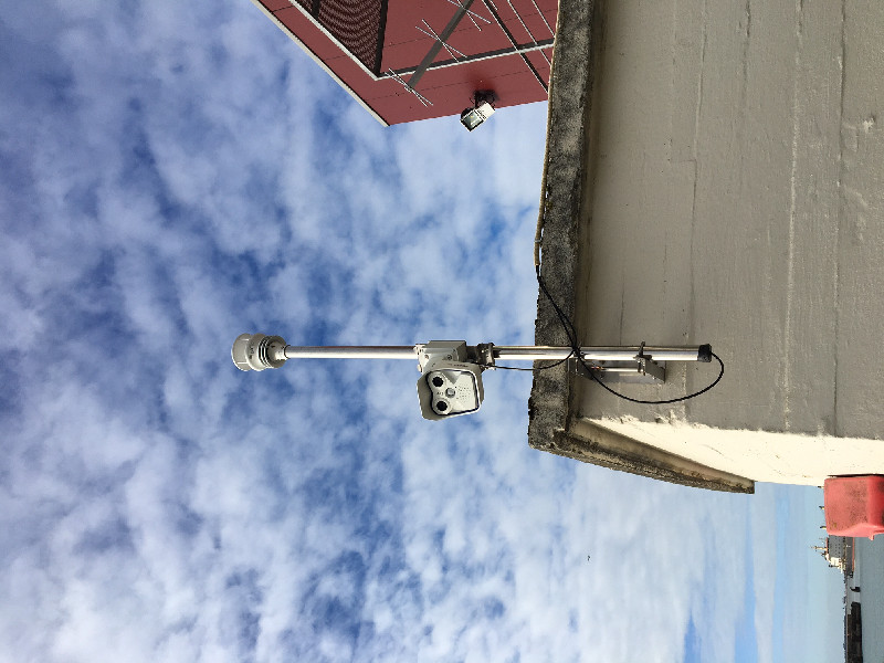
The 2017-10-14 and 2017-10-15, the GNSS receiver has been moved to the bunker roof and is now powered via solar panels and connected through a wifi bridge. Everything is up and running.
2012-01-06 (02/08/2017)
January 6 2012 : The backup benchmarks 100 and 200 were destroyed.
2015-08-19 (02/08/2017)
Mesures de Gravimétrie absolue effectuées sur le repère du bunker par Nicolas Le Moigne et Michaël Bonno de Montpellier (UMR 5243) du 2015-08-18 au 2015-08-19.
Matériel: FG5.
Les jours précédents ils ont effectué des mesures similaires à l'île d'Aix.
2015-03-31 (02/08/2017)
Mesures de Gravimétrie absolue effectuées sur le repère du bunker par D.Rouxel et S.Lucas du SHOM du 2015-03-31 au 2015-04-01. Matériel: Microg-Lacoste A10. Les jours suivants, ils ont effectué des mesures similaires à l'île d'Aix.
2017-06-15 (02/08/2017)
Maintenance à la station LROC par E.Poirier le matin:
Arrivée sur site vers 9h15 environ.
- Je préviens la société Reel de mon arrivée et de mon intervention.
- Le passage est très encombré par le feuillage et le portail qui peut être démonté n'est pas accessible.
- Il y a un câble gris qui traîne dans les marche et sur le toit du bunker. Signalé à R.Constant.
- Je graisse les serres câbles et autres connectiques de l'antenne GNSS.
- Tension batterie 13.4V OK.
- Je mets l'interrupteur programmable à l'heure locale.
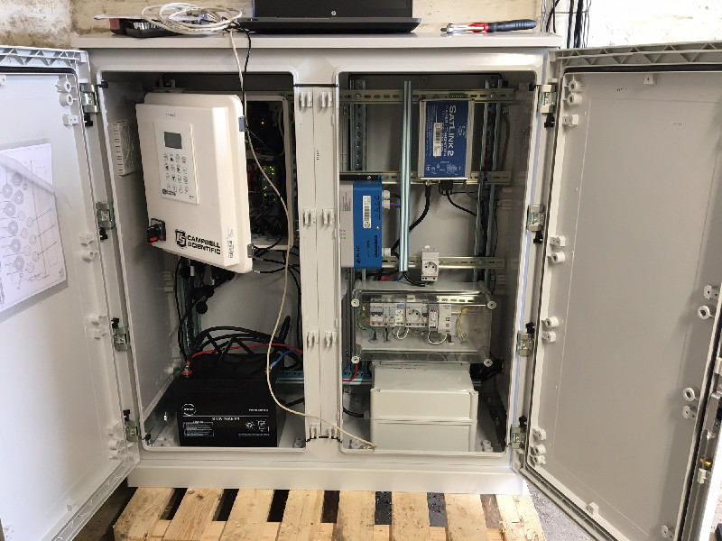
- Je bascule l'alimentation du récepteur GNSS sur external 2 et enlève la batterie interne qui de toutes les façons était déchargée. Ça ne charge pas sur le 12V. Il faut être en 24V.
- Je mets configure l'acess management comme pour tous les récepteur sonel avec un compte Admin et un compte User.
- Je vérifie que la connexion se fasse bien à 9h58 pendant 3 minutes.
L'interrupteur est programmé actuellement pour se connecter à h:59 pendant 3 minutes pour les 24 heures de chaque jour sauf à 14:59 où il se connecte pendant 20 minutes.
Prévoir:
remplacement des câbles pas de l'inox, longueurs max 125 x 2 et 130 x 2.
mettre 4 écrous papillons en M6 pour la tôle d'inox
- Je contacte Didier Bellion et accède au toit de l'écluse. Tout est en ordre là-haut.
[EUREFmail-8078] - 2015-07-27 (29/07/2015)
LROC: New GNSS receiver LEICA GR25 Pro installed on the 25th of
June 2015. However, we are still facing network issues and are unable to
send the data to our server. For the moment the data is stored locally
on the receiver SD card and will be uploaded as soon as possible.


